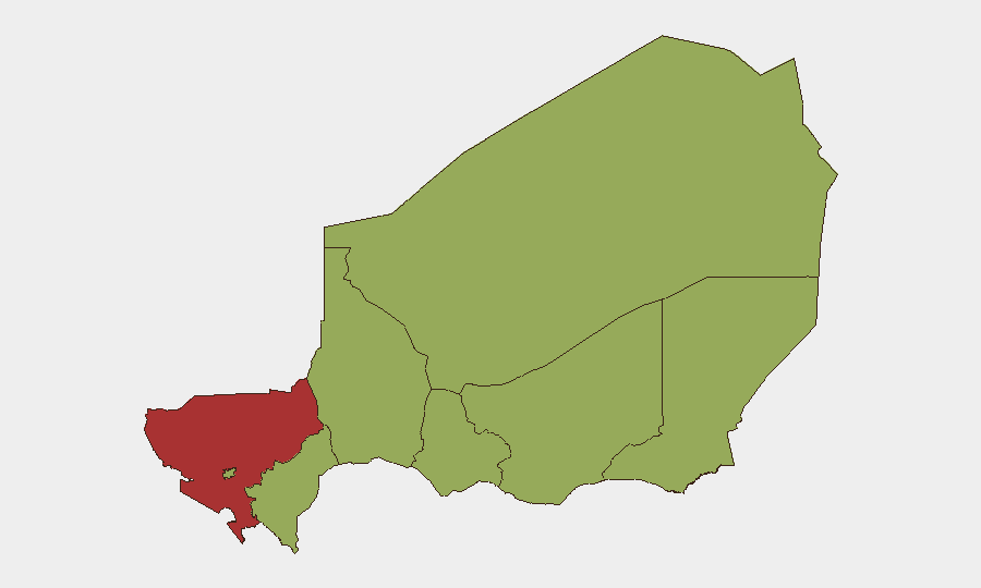
Situation Summary
Niger remains at rank #25 globally for composite security threat, driven primarily by active insurgency operations in the Sahel. The most recent significant incident—a 17 July terrorist ambush on a Defense and Security Forces patrol near Doungouro village in Tillabéri Region that killed 16 soldiers—has triggered ongoing sweep and search operations, but no newly corroborated discrete security incidents have been recorded nationwide in the 24–48 hours ending 22 July. The security environment remains volatile, particularly across the northwestern and eastern border regions, though current reporting suggests a temporary lull rather than de-escalation.
Key Developments
- Nigerien Military Operations (22 July). Continued military force operations underway, likely related to search and sweep follow-up to the 17 July Doungouro ambush and broader counterinsurgency activity. Specific location and scope not yet detailed in corroborated open reporting.
- Government Demonstration Response (20 July). A demonstration or rally directed at the Niger government was recorded on 20 July; context and location within Niger pending clarification in secondary sources.
- Terrorist Attack Sequence (20 July). A terrorist conventional military force action on 20 July has been recorded; this may reflect ongoing operations related to or distinct from the 17 July Téra–Bankilaré axis incident.
- Cross-Border Threat Signal (20 July). Ghana issued a threat toward Niger on 20 July, likely related to border security or transnational insurgent movement; the nature and severity of the threat remain under analysis.
- Nigerien Counter-Insurgency Action (20 July). Niger Defense and Security Forces conducted a conventional military operation against a terrorist target on 20 July as part of ongoing counterinsurgency operations.
- Arrest/Detention (22 July). Niger security forces conducted an arrest or detention of an operative on 22 July; identity and location not yet confirmed in open reporting.
*Note: The 17 July Doungouro incident (16 soldiers killed, 23 injured, 15 attackers reported killed) remains the most significant recent event and continues to drive operational tempo, but falls outside the strict 24–48-hour window.*
Highest-Risk Areas
Tillabéri Region, scoring 76.4, is the single highest-risk sub-national area and the primary driver of Niger's overall threat ranking, reflecting sustained terrorist activity along the Mali and Burkina Faso borders, particularly the Téra–Bankilaré corridor. Agadez, Zinder, and Diffa Regions follow at 46.4, each hosting ongoing insurgent cells and cross-border movement; Diffa especially remains a corridor for Boko Haram and Islamic State West Africa Province (ISWAP) activity. The capital, Niamey (46.4), carries heightened risk from political instability signals and potential secondary effects of regional insurgency. Tahoua, Dosso, and Maradi Regions at 46.4 round out the landscape but remain secondary in near-term operational intensity.
How GeoBit Would Assist
Intel Sweep, OSINT fusion, and multi-language search enable continuous monitoring of Telegram and encrypted channels used by terrorist cells and militia networks to detect attack planning and intent. AOI Monitoring & Early Warning with persistent watch over Tillabéri, Diffa, and Agadez would provide alert capability on mobilization and movement before incidents occur. Battle mapping, force-structure tracking, and Routing & Network Analysis support corporate security teams in identifying safe transit corridors, timing movement away from high-threat periods, and assessing checkpoint and border-crossing risk in real time.
7-Day Outlook
Counterinsurgency operations are expected to remain active in Tillabéri and Diffa through the near term, with sweep operations likely to continue into late July and early August. The 20 July Ghana–Niger border signal warrants monitoring for potential escalation or coordinated cross-border activity. No major political transition or nationwide security event is currently signaled for the next 7 days, but the security environment remains tactically unpredictable and casualty-prone.
Highest-Risk Areas — Ranked
| # | State / Region | Risk |
|---|---|---|
| 1 | Tillabéri Region | 76.4 |
| 2 | Agadez Region | 46.4 |
| 3 | Zinder Region | 46.4 |
| 4 | Diffa Region | 46.4 |
| 5 | Niamey | 46.4 |
| 6 | Tahoua Region | 46.4 |
| 7 | Dosso Region | 46.4 |
| 8 | Maradi Region | 46.4 |
Sources
Previous Daily Briefs
A new Niger brief is written every day — each with its own risk map and downloadable CSV. Here's the last week; use the calendar to go further back.
📅 Browse every day by calendar →
Highlighted days have a brief. Tap a day for that day's map & analysis, or “csv” for that day's dataset ($5).
Atlas — our AI intelligence desk — emails them this snapshot personally. Nothing else, no list.