Situation Summary
South Sudan remains in a state of protracted fragility driven by armed-group activity, communal conflict, and cattle-raiding dynamics concentrated in the oil-rich north and northeastern states. The national threat composite score (65) reflects persistent war-related risk; however, the last 24–48 hours show no major new incident reports from inside South Sudan itself. Political engagement on regional conflicts—including high-level talks in Juba on 17 August regarding the Sudan civil war—indicates continued spillover-risk management, but no direct escalation to South Sudan's security posture has been recorded in this reporting window.
Key Developments
- Juba, Central Equatoria – 17 August 2026 – President Salva Kiir met Darfur governor Minni Minnawi to discuss Sudan conflict resolution. While not a direct security incident, such talks reflect ongoing concern about cross-border conflict spillover and regional stability coordination in the capital.
- Pading, Jonglei State – 17–18 August 2026 – UNMISS patrol assessment reports the locality as "generally calm" but confirms that insecurity in surrounding areas continues to displace families and create ongoing humanitarian and protection concerns. Travel and movement risk remains elevated despite localized stability.
- No major new clashes or communal violence reported within the 24–48 hour window. Earlier high-casualty attacks in Tonj North County and neighboring communities (around 11–12 August, killing dozens) remain the most recent significant events on the public record but fall outside this reporting period.
- Baseline threat posture unchanged. Unity, Jonglei, and Upper Nile states remain under sustained armed-group and communal-militia pressure; no shift in force positioning or escalation ladder has been detected in current open-source feeds.
Highest-Risk Areas
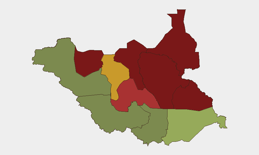
Unity (95), Jonglei (93), and Upper Nile (88) drive the national risk profile, all shaped by active competition over cattle, land, and oil resources, combined with persistent Nuer–Dinka and Murle–Nuer communal tensions. Greater Pibor (87) and Northern Bahr el Ghazal (82) present similar dynamics of armed-youth militia activity and intercommunal raiding. By contrast, the Equatorias—particularly Central (35) and Western (38)—show substantially lower composite risk, reflecting greater state capacity and fewer organized armed groups. Corporate and NGO personnel in the north should assume heightened baseline risk of intercommunal violence, cattle-raid escalation, and SSPDF counteraction; southern and central locations present materially lower threat profiles.
How GeoBit Would Assist
GeoBit's AOI Monitoring & Early Warning capability enables persistent surveillance of high-risk zones (Unity, Jonglei, Upper Nile) with automated alerting on new armed-group movements, militia mobilization, or intercommunal violence. OSINT Fusion & Corroboration (X/Telegram feeds, multi-language search, temporal analysis) rapidly distinguishes genuine current incidents from dated social-media claims and regional noise, reducing false alarms for duty-of-care teams. Routing & Network Analysis and GIS & Spatial Analysis support real-time route planning and travel-risk assessment for personnel in Central Equatoria or transit corridors, factoring live incident density and militia-control zones.
7-Day Outlook
No major escalation is anticipated in the immediate term; however, cattle-raiding season dynamics and ongoing SSPDF counterinsurgency operations in the north create sustained risk of localized clashes. Political talks in Juba suggest international focus on Sudan's conflict rather than South Sudan domestic instability, but spillover from refugee flows and armed-group cross-border movement could intensify pressure on Eastern Equatoria and Upper Nile. Security teams should maintain heightened vigilance in Unity and Jonglei states and assume no improvement in communal violence risk over the next 7–10 days.
Highest-Risk Areas — Ranked
| # | State / Region | Risk |
|---|---|---|
| 1 | Unity | 95 |
| 2 | Jonglei | 93 |
| 3 | Upper Nile | 88 |
| 4 | Greater Pibor Administrative Area | 87 |
| 5 | Northern Bahr el Ghazal | 82 |
| 6 | Lakes | 78 |
| 7 | Warrap | 72 |
| 8 | Ruweng Administrative Area | 68 |
| 9 | Eastern Equatoria | 52 |
| 10 | Western Equatoria | 38 |
| 11 | Central Equatoria | 35 |
| 12 | Western Bahr el Ghazal State | 28 |
Sources
Previous Daily Briefs
A new South Sudan brief is written every day — each with its own risk map and downloadable CSV. Here's the last week; use the calendar to go further back.
- August 16, 2026
- August 14, 2026
- August 12, 2026
- August 11, 2026
- August 10, 2026
- August 9, 2026
- August 7, 2026
📅 Browse every day by calendar →
Highlighted days have a brief. Tap a day for that day's map & analysis, or “csv” for that day's dataset ($5).
Atlas — our AI intelligence desk — emails them this snapshot personally. Nothing else, no list.