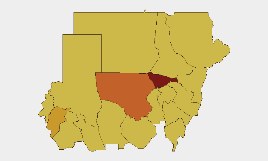
Situation Summary
Sudan remains in active civil conflict with composite threat ranking #4 globally (score 98/100), driven by intensive military operations between the Sudanese Armed Forces (SAF) and Rapid Support Forces (RSF) across multiple states. Over the past 72 hours, documented incidents include drone strikes on civilian infrastructure, market attacks, kidnappings for ransom, and massing of RSF forces around key urban centers. The conflict shows no sign of de-escalation; instead, attacks are expanding geographically and deliberately targeting water infrastructure, displacement camps, and commercial corridors.
Key Developments
- North Darfur, Tina area (20–21 July): RSF drone strikes killed at least 27 civilians and struck vital water infrastructure; secondary strike crossed into Chad, indicating sustained aerial capability and cross-border targeting of critical resources.
- North Darfur, Tina twin towns (week of 25 July): At least 21 additional deaths from drone attacks on the same locality within days, confirming repeated air threat and extreme risk for civilians and aid workers along the Sudan–Chad frontier.
- Blue Nile State, Badia area (23 July): SAF drone strike on a gathering of internally displaced people killed and injured dozens, predominantly women and children, signaling deliberate targeting of IDP concentrations.
- North Kordofan State, Ar Rahad (23 July): Drone attack on a civilian market killed at least two children, injured six minors (ages 6–14), and caused 24+ total casualties, demonstrating direct strikes on civilian commercial hubs.
- West Kordofan State, Saq al-Jamal area (week of 24 July): RSF patrol opened fire on a civilian vehicle, killing a six-year-old child and seriously injuring his brother; road movement in rural West Kordofan now extremely insecure.
- Border triangle zone, Egypt–Sudan–Libya (week of 20–24 July): Series of ambushes on commercial convoys resulted in at least ten civilian deaths; trade and logistics corridors face elevated risk of ambush, cross-fire, and asset seizure.
- North Kordofan State, El Obeid (25 July): UN Security Council issued demand for RSF to halt assault, warning of "imminent risk of mass atrocities" as RSF reinforced positions; city faces likely intense fighting and siege conditions.
- West Kordofan State (week of 20–24 July): Surge in civilian kidnappings for ransom across the state; personal travel and commercial transport carry elevated kidnap-for-ransom risk outside major towns.
Highest-Risk Areas
Al Khartum (98.2) dominates the risk ranking due to ongoing urban conflict and state concentration. North Kordofan State (74.1) and Central/North Darfur (71.6–70.8) follow, driven by active drone operations, market attacks, displacement crises, and RSF massing around El Obeid. River Nile, Kassala, Blue Nile, and multiple other states cluster at 68–69, reflecting distributed conflict across the country and sustained targeting of civilian infrastructure, markets, and IDP sites. The northern and central states bear the highest concentration of lethal incidents and humanitarian risk.
How GeoBit Would Assist
Corporate security teams would employ AOI Monitoring & Early Warning to track real-time activity in high-risk states (El Obeid, Ar Rahad, Tina, West Kordofan) with alerting on drone/attack incidents. Routing & Network Analysis can identify alternative supply and personnel movement corridors to avoid ambush zones and kidnap hotspots. Conflict & Military tracking plus OSINT fusion provide near-real-time force positioning and RSF/SAF operational intent, enabling duty-of-care escalation and evacuation decisions.
7-Day Outlook
El Obeid faces imminent risk of large-scale assault; humanitarian conditions will likely deteriorate rapidly. Drone operations across North Darfur, Blue Nile, and North Kordofan are expected to continue, with civilian infrastructure and displacement sites remaining priority targets. Kidnapping activity and banditry in West Kordofan and border zones will persist, making overland travel and supply runs increasingly dangerous without enhanced security measures.
Highest-Risk Areas — Ranked
| # | State / Region | Risk |
|---|---|---|
| 1 | Al Khartum | 98.2 |
| 2 | North Kordofan State | 74.1 |
| 3 | Central Darfur State | 71.6 |
| 4 | North Darfur State | 70.8 |
| 5 | River Nile State | 69.1 |
| 6 | Kassala State | 69.1 |
| 7 | Blue Nile | 68.2 |
| 8 | Aj Jazira | 68.2 |
| 9 | Red Sea State | 68.2 |
| 10 | Al Qadarif State | 68.2 |
| 11 | Sennar State | 68.2 |
| 12 | South Darfur State | 68.2 |
Sources
Previous Daily Briefs
A new Sudan brief is written every day — each with its own risk map and downloadable CSV. Here's the last week; use the calendar to go further back.
📅 Browse every day by calendar →
Highlighted days have a brief. Tap a day for that day's map & analysis, or “csv” for that day's dataset ($5).
Atlas — our AI intelligence desk — emails them this snapshot personally. Nothing else, no list.