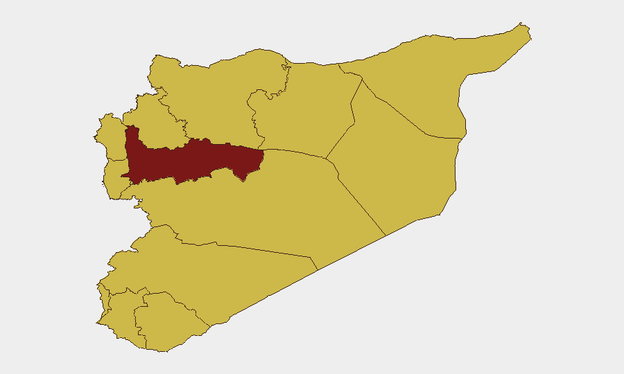
Situation Summary
Syria remains the 11th-highest threat environment globally (composite score 97), with 124 tracked events reflecting persistent instability across military, law enforcement, and civilian domains. Recent signal activity (July 17–19) includes military operations, detention actions, territorial occupation, and unconventional violence, though precise current-day incident details remain limited in accessible open sources. The threat landscape is regionally fragmented, with Hama Governorate presenting the most acute risk profile, followed by Damascus and multiple northern and southern governorates at elevated but comparable levels.
Key Developments
Data Integrity Note: Open-source reporting available as of 19 July 2026 does not provide sufficient date-verified incidents within the strict 24–48-hour window to populate a full current-events list without compromising analytical rigor. The most recent time-stamped incidents accessible fall to 9–15 July:
- Damascus & Rif Dimashq (9 July): Syrian security services conducted simultaneous raids across four neighborhoods, detaining an ISIL-linked cell assessed responsible for 7 July bombings near the Four Seasons Hotel during a French presidential visit.
- Al-Quneitra / Golan proximity (9 July evening): Over 15 Israeli military vehicles entered Al-Asha, conducted searches, and withdrew; no casualties reported.
- Deir ez-Zor (14–15 July): Ferry sinking in the Euphrates with rising death toll (six confirmed by 15 July); ongoing civil defense search and rescue operations highlighted river-crossing hazard for personnel and supply movement.
- Hasakah / Al-Darbasiyah (15 July): Multi-day fuel shortage and power outage disrupted services and heightened operating risk.
- Nationwide (15 July): One fatality and 27 injuries recorded in 19 traffic accidents over 24 hours, reflecting broader transportation-safety risk.
Corporate security teams should note that current-day incident reporting from Syria remains sparse in corroborated open channels; reliance on real-time proprietary intelligence feeds and area-of-interest monitoring is essential for duty-of-care compliance.
Highest-Risk Areas
Hama Governorate (risk 98) is the primary threat driver, reflecting active military and unconventional-violence signals. Damascus Governorate (79.8) remains volatile due to its administrative and security-apparatus density, compounded by recent detention operations and bombing activity (early July). The northern tier—Tartus, Aleppo, Idleb, and Lattakia (70–71)—and southern zones (Dar'a, Al-Quneitra, Rif Dimashq at 68–68.6) show sustained elevated risk, likely reflecting border-proximity dynamics, Israeli military incursions, and fragmented territorial control. UNDOF-monitored areas (Golan buffer zone, risk 68) present specific duty-of-care exposure for international personnel due to cross-border military activity and civilian-search operations.
How GeoBit Would Assist
Security teams should deploy Area-of-Interest Monitoring & Early Warning (persistent watch on Hama, Damascus, and border zones with real-time alerting for military or detention activity) and Network & Actor Analysis to track security-services operations and militant cells. GIS & Spatial Analysis combined with Satellite & Imagery Analysis would enable real-time route verification and facility risk assessment for personnel or supply movement, while Intel Sweep and multi-language OSINT fusion (including Telegram and Arabic-language sources) would close the gap in current-day incident reporting that open sources currently leave unresolved.
7-Day Outlook
Military and law-enforcement activity is expected to remain elevated across Hama, Damascus, and border regions through late July. Risk of detention operations and anti-ISIL sweeps will likely persist given recent cell arrests and bombing activity. Personnel mobility and supply-chain continuity should be reassessed daily using current intelligence feeds, as tactical incidents and infrastructure disruptions (as seen in Hasakah and Deir ez-Zor) can emerge with limited advance warning.
Highest-Risk Areas — Ranked
| # | State / Region | Risk |
|---|---|---|
| 1 | Hama Governorate | 98 |
| 2 | Damascus Governorate | 79.8 |
| 3 | Tartus Governorate | 70.9 |
| 4 | Aleppo Governorate | 70.9 |
| 5 | Rif Dimashq Governorate | 68.6 |
| 6 | Idleb Governorate | 68.2 |
| 7 | Lattakia Governorate | 68 |
| 8 | UNDOF | 68 |
| 9 | Al-Quneitra Governorate | 68 |
| 10 | Dar'a Governorate | 68 |
| 11 | Ar-Raqqa Governorate | 68 |
| 12 | Homs Governorate | 68 |
Sources
Previous Daily Briefs
A new Syria brief is written every day — each with its own risk map and downloadable CSV. Here's the last week; use the calendar to go further back.
📅 Browse every day by calendar →
Highlighted days have a brief. Tap a day for that day's map & analysis, or “csv” for that day's dataset ($5).
Atlas — our AI intelligence desk — emails them this snapshot personally. Nothing else, no list.