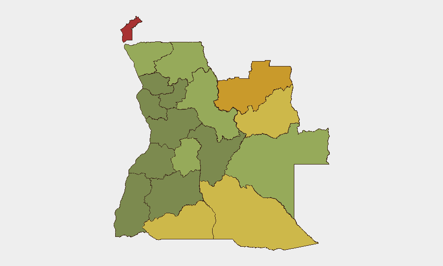
Situation Summary
Angola remains a composite mid-tier security risk (#56 globally, score 32) with concentrated threat density in the eastern border provinces. A pattern of localized violence, infrastructure disruption, and political tensions has surfaced over the past week, though no nationwide destabilization is evident. The security environment is fragmented by geography; while Luanda and coastal areas remain relatively stable, the diamond-rich eastern provinces and the enclave of Cabinda carry substantially elevated risk driven by armed group activity, smuggling networks, and weak state presence.
Key Developments
- Uíge Province, 2026-08-08: Angolan National Police conducted a intervention at or near UNITA's provincial headquarters, resulting in injuries to party members. Reports of casualty counts vary (2–31 cited across sources), reflecting the difficulty in independent verification; the incident signals continued political tension and police assertiveness in opposition strongholds.
- Luanda, 2026-08-07 to 2026-08-10: Unitel's cyberattack-related service disruption persisted, constraining digital payments and fund transfers across the capital. Partial restoration occurred, but payment infrastructure remained degraded, affecting business continuity and cash-dependent sectors.
- Sumbe region (Kwanza Sul), 2026-08-05: A passenger bus collided with a fuel tanker approximately 20 km from Sumbe, triggering an explosion and fire with significant casualties and localized infrastructure damage. The incident underscores road-safety and hazmat-transport vulnerabilities on key regional corridors.
- Calomboloca Penitentiary (Icolo e Bengo), 2026-08-07: An accidental firearm discharge killed one prison officer and injured another. Classified as an internal security incident; no indication of broader public-order spillover.
- Mulenvos Municipality, Luanda, 2026-08-07: Police arrested an 18-year-old suspect in a homicide case involving a neighbor. Assessment indicates localized violent crime without organized-crime indicators.
Highest-Risk Areas
Cabinda Province (risk 78) and the two Lunda provinces (Norte 72, Sul 68) dominate the threat landscape, driven by persistent armed-group presence, cross-border smuggling of diamonds and weapons, and limited state administrative capacity. Cuando Cubango and Cunene provinces (risks 64 and 62, respectively) face parallel pressures from porous southern borders and illicit trafficking networks. In contrast, Luanda and coastal zones remain substantially safer, though recent political violence and cyber incidents indicate that security cannot be assumed even in the capital. Eastern and southern Angola should be treated as high-friction zones requiring enhanced due diligence for personnel and asset protection.
How GeoBit Would Assist
Security teams operating in Angola should deploy AOI Monitoring & Early Warning on Cabinda and the Lunda provinces to detect cross-border weapons and smuggling movements before they escalate into local conflict. Intel Sweep and X/Twitter & Telegram OSINT capabilities enable real-time tracking of political tensions and police actions that may affect expatriate safety or business operations. GIS & Spatial Analysis and alternative route/journey planning tools are essential for transit security in regions where road incidents and infrastructure disruption occur; satellite and imagery analysis can support supply-chain and asset-protection planning in remote eastern zones.
7-Day Outlook
No imminent nationwide destabilization is forecast. Political tensions between the government and UNITA may generate additional localized incidents, particularly in opposition strongholds in the north and east. Infrastructure vulnerabilities—roads, power networks, and digital systems—will likely persist, requiring contingency planning for business continuity and staff safety.
Highest-Risk Areas — Ranked
| # | State / Region | Risk |
|---|---|---|
| 1 | Cabinda Province | 78 |
| 2 | Lunda Norte Province | 72 |
| 3 | Lunda Sul Province | 68 |
| 4 | Cuando Cubango Province | 64 |
| 5 | Cunene Province | 62 |
| 6 | Moxico Province | 58 |
| 7 | Zaire Province | 54 |
| 8 | Huambo Province | 50 |
| 9 | Uíge Province | 48 |
| 10 | Malanje Province | 42 |
| 11 | Bié Province | 35 |
| 12 | Huíla Province | 32 |
Sources
Previous Daily Briefs
A new Angola brief is written every day — each with its own risk map and downloadable CSV. Here's the last week; use the calendar to go further back.
📅 Browse every day by calendar →
Highlighted days have a brief. Tap a day for that day's map & analysis, or “csv” for that day's dataset ($5).
Atlas — our AI intelligence desk — emails them this snapshot personally. Nothing else, no list.