Situation Summary
Central African Republic remains ranked #30 globally (composite threat score 68) with a pervasive, structurally high-risk security environment driven by armed fragmentation, chronic instability, and limited state capacity. The country remains under U.S. Level 4 "Do Not Travel" advisory nationwide. Current trajectory shows no major escalation in the last 24–48 hours, but ongoing UN peacekeeping drawdown is reducing static security presence across multiple regions, creating potential operational gaps heading into the latter half of 2026.
Key Developments
- Nationwide – UN MINUSCA base handover and drawdown (mid-July 2026, ongoing). MINUSCA has handed over seven military bases to CAR authorities and closed 21 bases year-to-date as part of a 2026 strategic drawdown; shift to more mobile operations is reported to increase vulnerability to armed-group activity in remote areas, particularly in the eastern and northern prefectures.
- Nationwide – U.S. Level 4 travel advisory reaffirmed (recent news cycle, no change in status). Central African Republic remains under the highest U.S. travel-risk designation due to crime, civil unrest, and armed conflict; advisory status shows no deterioration but confirms sustained extreme-risk baseline for all movement and operations.
- No verifiable new attacks or civil-unrest incidents in the last 24–48 hours identified in open-source reporting. While localized banditry, checkpoint incidents, and lower-level armed-group activity are endemic, major flashpoints, clashes, or protests do not appear in indexed global news or social-media monitoring for the immediate period.
Highest-Risk Areas
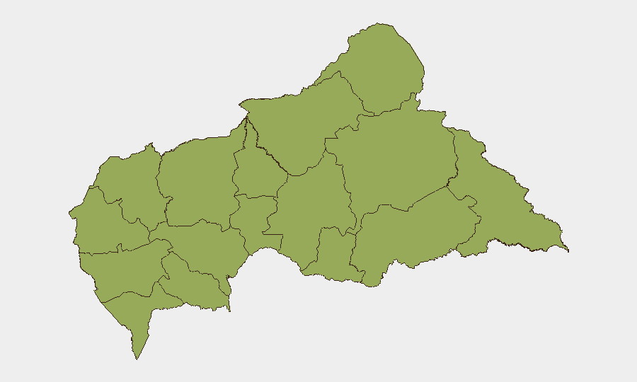
All twelve prefectures rank identically (47.2 composite risk), reflecting the geographically distributed nature of CAR's instability. Eastern and northern prefectures—Vakaga, Haut-Mbomou, Mbomou, and Bamingui-Bangoran—see elevated driver activity due to proximity to Sudan border (cross-border militant infiltration, refugee flows) and historical rebel strongholds. Ouham, Ouham-Pendé, and Nana-Mambéré in the northwest remain volatile due to armed-group presence and weak state authority. Uniform risk coding suggests GeoBit's current model does not yet differentiate micro-level variance; human analysis of specific routes, checkpoints, and armed-group positions within each prefecture remains necessary for tactical movement planning.
How GeoBit Would Assist
AOI Monitoring & Early Warning paired with OSINT fusion (X/Telegram, local-language radio SIGINT, YouTube/podcast intelligence) would enable real-time detection of emerging clashes, checkpoint disruptions, or rebel activity before they escalate into major incidents or block critical routes. Routing & Network Analysis combined with GIS & Spatial Analysis can model alternative journey corridors and identify higher/lower-risk transit windows as MINUSCA presence retracts and armed-group territorial control shifts. Conflict & Military force-structure tracking allows security teams to monitor which armed groups hold which zones and predict mobility corridors for personnel or supply convoys.
7-Day Outlook
No major escalation is signaled in the immediate term, but the ongoing MINUSCA drawdown will continue reducing international static presence through July and August, likely increasing localized armed-group assertion and banditry in remote and border areas. Personnel and asset movement should assume baseline extreme-risk posture with heightened vigilance in the northeast and northwest prefectures. Checkpoint incidents and criminal roadside activity may increase as UN force-protection capacity declines.
Highest-Risk Areas — Ranked
| # | State / Region | Risk |
|---|---|---|
| 1 | Bamingui-Bangoran | 47.2 |
| 2 | Vakaga | 47.2 |
| 3 | Haute-Kotto | 47.2 |
| 4 | Haut-Mbomou | 47.2 |
| 5 | Mbomou | 47.2 |
| 6 | Nana-Mambéré | 47.2 |
| 7 | Ouham-Pendé | 47.2 |
| 8 | Mambéré-Kadéï | 47.2 |
| 9 | Sangha-Mbaéré | 47.2 |
| 10 | Ouham | 47.2 |
| 11 | Nana-Grébizi | 47.2 |
| 12 | Kémo | 47.2 |
Sources
Previous Daily Briefs
A new Central African Republic brief is written every day — each with its own risk map and downloadable CSV. Here's the last week; use the calendar to go further back.
📅 Browse every day by calendar →
Highlighted days have a brief. Tap a day for that day's map & analysis, or “csv” for that day's dataset ($5).
Atlas — our AI intelligence desk — emails them this snapshot personally. Nothing else, no list.