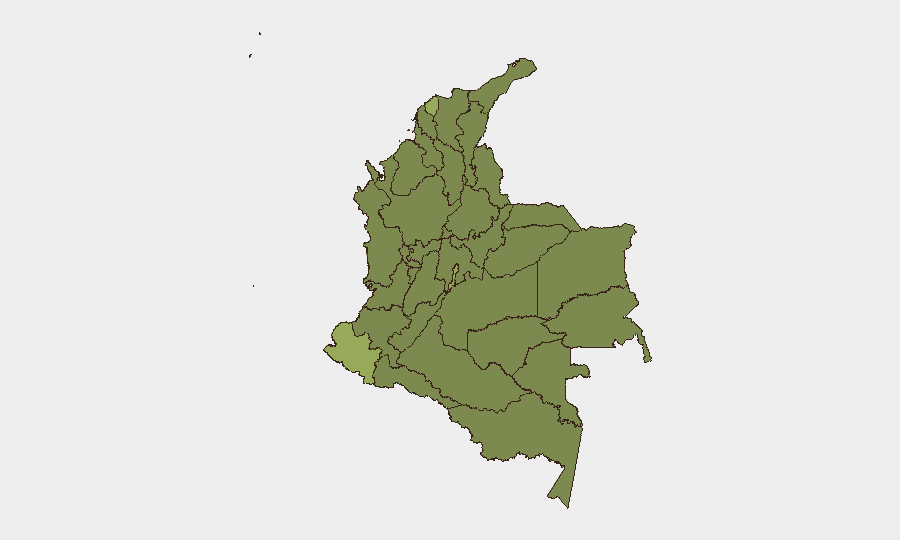
Situation Summary
Colombia remains at moderate-to-elevated risk (global rank #30) amid active armed conflict in rural southwestern departments, coordinated criminal violence in urban centers, and sustained pressure on security forces. FARC dissident structures continue ground operations in Cauca and Norte de Santander, while organized-crime homicides persist in Valle del Cauca and the capital region. A reported "plan pistola" targeting police and military has prompted nationwide security posture increases, signaling organized coordination of anti-state violence.
Key Developments
- Cauca, El Tambo (Wísitó corregimiento), 26–27 July 2026: Armed clashes between FARC dissident group Carlos Patiño and Colombian Army resulted in 7 soldiers and 6 civilians injured; 2 dissident combatants killed; helicopter support sustained combat damage with 1 pilot wounded. Operations ongoing.
- Bogotá, Usaquén (barrio Soratama), night of 26 July 2026: Ride-hailing driver shot and killed during violent robbery; security camera footage led to arrest of 2 suspects charged with aggravated homicide, theft, and illegal weapons possession.
- Cauca/southwest Colombia, 26–27 July 2026: Military sources reported sustained ground and air operations against FARC dissident Carlos Patiño structure; helicopter evacuation of wounded underway in rural theater.
- Norte de Santander, Tibú area, through 26–27 July 2026: Army destroyed FARC-dissident explosives depot and 180 anti-personnel mines during illicit crop eradication, reducing immediate threat to troops and civilians.
- Valle del Cauca, Cartago, through 26–27 July 2026: High-value reward offered for information on perpetrators of mass shooting (5 dead, 2 children injured); investigators attribute attack to criminal gang conflict; case prioritized as homicide and organized-crime investigation.
- National security alert, 26–27 July 2026: Colombian authorities issued warning of coordinated "plan pistola" targeting police and military across multiple regions; security agencies escalating precautions and investigative response.
- Southwest airspace, Popayán area, from 26 July 2026: Puracé volcano ash emissions prompted civil aviation authority to suspend operations at Guillermo León Valencia Airport in Popayán at least through Friday, restricting regional air mobility.
Highest-Risk Areas
Nariño (55.7) and the Capital District (53.2) drive the highest composite risk scores, reflecting sustained FARC dissident activity in the southwest borderlands and organized homicide in metropolitan Bogotá respectively. Atlántico Department (42.2) and Cesar (32.1) show elevated risk linked to criminal gang presence and resource-trafficking routes. The concentration of events in Cauca, Valle del Cauca, and Bogotá reflects both active armed conflict and urban criminal violence; northern departments (Norte de Santander, Arauca, La Guajira) remain critical due to dissident operations and illicit economy activity.
How GeoBit Would Assist
GIS & Spatial Analysis and AOI Monitoring with persistent alerting on Cauca, Nariño, and Capital District enable corporate teams to track real-time conflict intensity and criminal hotspots. Intel Sweep, OSINT fusion, and Network & Actor Analysis provide early warning of coordinated attacks ("plan pistola") and dissident group movements. Routing & Network Analysis supports duty-of-care teams in identifying safe transit corridors and alternative logistics given airport closures and armed clashes.
7-Day Outlook
FARC dissident Carlos Patiño operations in Cauca are expected to persist given recent Army engagement; helicopter and logistics constraints may limit immediate military follow-on. Urban homicide pressure in Bogotá and Valle del Cauca will likely remain elevated pending organized-crime investigative outcomes. Puracé airspace restrictions are forecast to ease by midday 28 July, restoring regional air mobility.
Highest-Risk Areas — Ranked
| # | State / Region | Risk |
|---|---|---|
| 1 | Nariño | 55.7 |
| 2 | Capital District | 53.2 |
| 3 | Atlántico Department | 42.2 |
| 4 | Cesar Department | 32.1 |
| 5 | Sucre Department | 31.6 |
| 6 | Cundinamarca Department | 31.6 |
| 7 | Magdalena Department | 31.2 |
| 8 | Arauca Department | 31.2 |
| 9 | Cauca | 28.9 |
| 10 | Valle del Cauca Department | 28 |
| 11 | Boyacá Department | 27.1 |
| 12 | La Guajira | 26.6 |
Sources
Previous Daily Briefs
A new Colombia brief is written every day — each with its own risk map and downloadable CSV. Here's the last week; use the calendar to go further back.
📅 Browse every day by calendar →
Highlighted days have a brief. Tap a day for that day's map & analysis, or “csv” for that day's dataset ($5).
Atlas — our AI intelligence desk — emails them this snapshot personally. Nothing else, no list.