Situation Summary
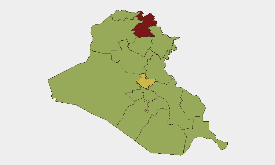
Iraq remains a complex, multi-layered threat environment driven by insurgent activity, cross-border military strikes, and unresolved Iran–U.S. tensions. The country ranks #14 globally in composite threat with 273 tracked events, with the highest concentration of risk in Erbil Governorate (81.5), reflecting ongoing drone and missile activity in Iraqi Kurdistan. Political and diplomatic friction—evident in recent public statements and investigative actions between Iraqi and Iranian authorities—intersect with sporadic armed clashes and unconventional violence targeting military infrastructure.
Key Developments
Data Integrity Note: Open-source web, news, and social-media feeds currently lack sufficient granularity to confirm discrete security incidents, attacks, or civil-unrest events strictly within the 24–48 hours prior to 2026-07-26. Recent reporting on drone activity, cross-border strikes, and military operations in Erbil and Sulaymaniyah is clearly dated to 24 July or earlier; no new attack, clash, or unrest event can be confidently placed in the last 24–48 hours from available public reporting.
GeoBit's internal event signals (ACLED-type feeds) record:
- Diplomatic/Political friction (24–26 July): Iranian rejection statements, Iraqi investigative actions, and public statements from Iraqi authorities and media concerning Iran-related matters.
- Armed activity (25 July): Small-arms combat in Kurdistan vs. security forces; unconventional violence against a military base (location/details unclear from available open source).
- Abduction/hostage incident (25 July): One incident flagged; no open-source confirmation of details.
Recommended action: Validate these signals against confidential intelligence feeds and local on-ground sources for location specificity and threat characterization.
Highest-Risk Areas
Erbil Governorate dominates the risk profile at 81.5, driven by persistent drone and cross-border missile activity linked to Iran–U.S. proxy dynamics and Kurdish militant operations. Baghdad Governorate (68.1) reflects the capital's status as a political and security hub where demonstrations, diplomatic tensions, and targeted violence intersect. Southern and central governorates (Dhi Qar, Al-Najaf, Al-Anbar, Babil, Wasit, and others) cluster in the 51–57 range, indicating a baseline of insurgent presence, sectarian friction, and periodic armed clashes. The persistent elevation of Erbil, combined with recent signals of armed activity and diplomatic strain, suggests that cross-border military operations and internal security force confrontations remain the primary drivers.
How GeoBit Would Assist
Teams with personnel or assets in Iraq should deploy AOI (Area-of-Interest) Monitoring & Early Warning on Erbil, Baghdad, and southern governorate nodes to capture drone activity, armed clashes, and protest/gathering alerts in real time. OSINT Fusion & Corroboration (including Telegram, X/Twitter, local news, and radio SIGINT) will resolve timing and location specificity for incidents currently flagged in event feeds. Routing & Network Analysis supports security teams in identifying and regularly validating alternative supply-chain routes, border crossings, and staff movement corridors in high-risk zones.
7-Day Outlook
Expect continued elevated tension in Erbil and Sulaymaniyah tied to regional military dynamics; no de-escalation is signaled. Sporadic armed clashes between Iraqi security forces and Kurdish actors, or unconventional attacks on military installations, remain probable. Monitor diplomatic channels and public statements from Iraqi and Iranian officials for signals of negotiation or renewed conflict—these often precede tactical shifts.
Highest-Risk Areas — Ranked
| # | State / Region | Risk |
|---|---|---|
| 1 | Erbil Governorate | 81.5 |
| 2 | Baghdad Governorate | 68.1 |
| 3 | Dhi Qar Governorate | 57.6 |
| 4 | Al-Najaf Governorate | 52.4 |
| 5 | Al-Anbar Governorate | 52.1 |
| 6 | Babil Governorate | 51.5 |
| 7 | Wasit Governorate | 51.5 |
| 8 | Al-Qadisiyah Governorate | 51.5 |
| 9 | Al-Muthanna Governorate | 51.5 |
| 10 | Maysan Governorate | 51.5 |
| 11 | Al-Basra Governorate | 51.5 |
| 12 | Saladin Governorate | 51.5 |
Sources
Previous Daily Briefs
A new Iraq brief is written every day — each with its own risk map and downloadable CSV. Here's the last week; use the calendar to go further back.
📅 Browse every day by calendar →
Highlighted days have a brief. Tap a day for that day's map & analysis, or “csv” for that day's dataset ($5).
Atlas — our AI intelligence desk — emails them this snapshot personally. Nothing else, no list.