Situation Summary
Lebanon faces acute and escalating security risks centered on the Israeli–Hezbollah border confrontation in the south, compounded by cross-border artillery exchanges and ongoing drone operations. As of 2 August 2026, conventional military clashes, shelling of strategic positions, and strikes on civilian infrastructure are intensifying across South and Nabatieh governorates. The US Embassy has issued an urgent evacuation recommendation for US citizens, and UN peacekeeping personnel have been wounded, signaling deterioration of the ceasefire framework and rising collateral-damage risk to international actors and civilians.
Key Developments
- South Lebanon, Shebaa Farms – 1 August 2026: Israeli forces reported killing an armed militant in the contested security zone during an encounter with suspected Hezbollah fighters, marking a direct engagement in a strategically sensitive area.
- Ali al-Taher hill, near Nabatieh – Night of 31 July–1 August 2026: Israeli artillery conducted intensive shelling of the strategic hilltop, with Israeli claims of Hezbollah tunnel networks; local media reported sustained explosions and ongoing military activity.
- UNIFIL position, El Adeisse – 31 July 2026: An explosion at or near a UN peacekeeping post injured three UNIFIL personnel, two seriously; cause remains under investigation, exposing peacekeepers to direct threat.
- US Embassy advisory, countrywide – 31 July 2026 (ongoing): The US Embassy issued an urgent directive for all US citizens to depart Lebanon without delay, citing Israeli airstrikes and drone operations in Beirut, the south, and Beqaa Valley, as well as potential militia threats against US-linked facilities.
- Southern border villages near Beaufort Castle – 31 July–1 August 2026: Israeli airstrikes targeted towns in the Maroun al-Ras area as part of operations against reported Hezbollah tunnel infrastructure; the IDF reported use of hundreds of tonnes of explosives in recent days, with local infrastructure damage documented.
- Cross-border shelling, general border area – 31 July–1 August 2026: Repeated artillery exchanges and drone activity between Israeli forces and Hezbollah units across multiple border villages indicate systematic violations of the ceasefire and sustained tactical momentum.
Highest-Risk Areas
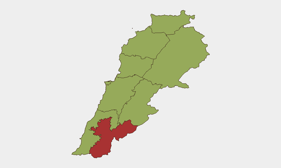
Nabatieh Governorate (76.9 risk score) dominates the threat landscape and accounts for the majority of active military engagement, particularly around Ali al-Taher, Shebaa Farms, and villages near Beaufort Castle. Keserwan-Jbeil (55.6) and Beirut (52.7) follow as secondary concerns, reflecting Israeli drone and airstrike activity in and around the capital and the northern coastal districts. The remaining seven governorates cluster at 46.9 risk score, indicating country-wide exposure; however, the southern concentration in Nabatieh reflects the epicenter of current conventional military operations and the highest probability of civilian impact.
How GeoBit Would Assist
Security teams should deploy AOI Monitoring & Early Warning with persistent satellite and OSINT watch on Nabatieh, South Governorate, and Beirut to detect airstrike patterns, military repositioning, and infrastructure damage in real time. Conflict & Military battle mapping and force-structure tracking would establish the current disposition of Hezbollah and Israeli units along the Blue Line and provide predictive context for escalation. GIS & Spatial Analysis combined with Routing & Network Analysis enables identification of safe transit corridors in and out of Beirut and alternative logistical pathways for personnel extraction and asset relocation.
7-Day Outlook
Barring a diplomatic intervention or significant ceasefire agreement, cross-border military activity will likely sustain or intensify over the next week, with artillery and drone operations remaining the dominant threat vectors. Civilian infrastructure damage in the south and risk to international presence (diplomatic, NGO, UN) will remain elevated. Any direct Hezbollah retaliation against Israeli territory could trigger wider escalation involving regional actors and further restrict movement and commercial activity in Lebanon.
Highest-Risk Areas — Ranked
| # | State / Region | Risk |
|---|---|---|
| 1 | Nabatieh Governorate | 76.9 |
| 2 | Keserwan-Jbeil Governorate | 55.6 |
| 3 | Beirut Governorate | 52.7 |
| 4 | North Governorate | 46.9 |
| 5 | Akkar Governorate | 46.9 |
| 6 | Mount Lebanon Governorate | 46.9 |
| 7 | South Governorate | 46.9 |
| 8 | Beqaa Governorate | 46.9 |
| 9 | Baalbek-Hermel Governorate | 46.9 |
Sources
Previous Daily Briefs
A new Lebanon brief is written every day — each with its own risk map and downloadable CSV. Here's the last week; use the calendar to go further back.
📅 Browse every day by calendar →
Highlighted days have a brief. Tap a day for that day's map & analysis, or “csv” for that day's dataset ($5).
Atlas — our AI intelligence desk — emails them this snapshot personally. Nothing else, no list.