Situation Summary
Mali remains at critical risk (global rank #10, composite score 100) with security conditions dominated by sustained militant activity, army instability, and governmental friction across the Sahel. The most significant confirmed incident—a major ambush on 18 July of a joint Malian Armed Forces and Russian Africa Corps convoy near Tabankort in Gao region—underscores the operational capacity of JNIM and Tuareg separatist groups to inflict heavy casualties on state forces and raises questions about force coordination and route security in the north. No new, reliably dated security events have been independently confirmed for 19–20 July as of this report; however, the recent ambush and associated army dissent signals indicate heightened risk of further northern corridor incidents and potential internal military tensions.
Key Developments
- Tabankort ambush, Gao region – 18 July 2026 (confirmed)
Armed groups including al‑Qaeda affiliate JNIM and the Azawad Liberation Front (FLA) ambushed a Malian army convoy departing Anefis toward Gao. At least 50 Malian soldiers reported killed; multiple armored vehicles destroyed and equipment seized. Described by regional sources as one of deadliest attacks on Malian forces in years; incident confirmed by Malian military and multiple media outlets.
- Anefis–Gao transit corridor – 18 July 2026 (ongoing assessment)
The ambush demonstrates insurgent capability to stage large, coordinated attacks against high-profile military traffic on a key northern supply route. Route assessed as high-risk for all convoys; travel advisory level elevated for this corridor.
- Army dissent signals – 19 July 2026 (event flag)
Multiple event signals catalogued on 19 July indicate internal military disapproval and unconventional violence by military and Mali-aligned actors; context and specific incidents not yet clarified in open sources but flagged as potential indication of command instability or inter-unit friction.
- Government administrative sanctions – 20 July 2026 (event signal)
A government sanction event recorded; details unavailable in current open-source environment but warrants monitoring for policy shifts affecting security operations or personnel.
*No additional independently confirmed security or civil-unrest incidents have been identified for the strict 19–20 July window; earlier events are context only.*
Highest-Risk Areas
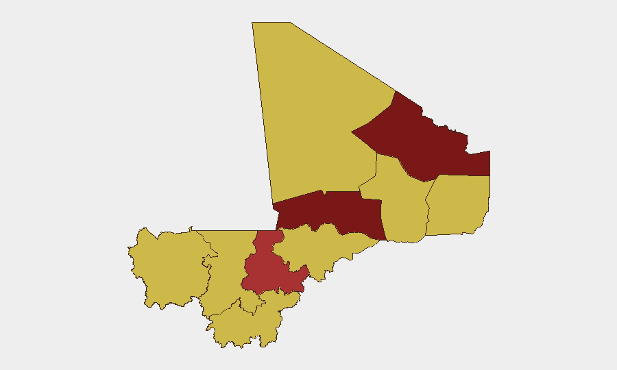
Bamako (risk 100) remains the highest-risk location nationwide, reflecting the capital's role as a locus of political tension, military command authority, and civilian vulnerability. The northern tier—Kidal (84.4), Timbuktu (83.3), and Gao (70)—are dominated by active JNIM and FLA operations, cross-border militant infiltration, and limited state control; the Tabankort ambush exemplifies this. Ségou (76.7) and the Kayes/Taoudénit/Ménaka corridor (all 70) are secondary flashpoints where supply lines and outlying military positions face recurring attack. The consistent risk score of 70 across six southern and central regions signals diffuse lower-level threat rather than acute concentration, but Bamako's 100 score and the north's 80+ ratings demand prioritization.
How GeoBit Would Assist
Corporate security teams should employ AOI (Area-of-Interest) Monitoring & Early Warning on Bamako and the Gao–Ségou–Timbuktu corridor to receive real-time alerts on ambushes, checkpoints, and armed group movement. Intel Sweep and multi-language OSINT (X, Telegram, radio SIGINT) provide 24–48-hour early indicators of planned operations. Routing & Network Analysis capabilities can identify safer, dynamic alternatives to the Anefis–Gao road and other high-threat corridors for personnel movement and supply convoys.
7-Day Outlook
Militant ambush activity and northern corridor instability are expected to persist over the near term; the Tabankort success will likely encourage further JNIM and FLA operations against military traffic. Internal army friction, signalled on 19 July, may complicate force coordination and increase risk of unpredictable incidents. Bamako's administrative response (20 July signal) may signal policy shifts; monitoring for curfews, movement restrictions, or personnel changes is warranted.
Highest-Risk Areas — Ranked
| # | State / Region | Risk |
|---|---|---|
| 1 | Bamako | 100 |
| 2 | Kidal | 84.4 |
| 3 | Timbuktu | 83.3 |
| 4 | Ségou Region | 76.7 |
| 5 | Ménaka | 70 |
| 6 | Kayes | 70 |
| 7 | Taoudénit Region | 70 |
| 8 | Gao | 70 |
| 9 | Koulikoro | 70 |
| 10 | Sikasso Region | 70 |
| 11 | Mopti | 70 |
Sources
Previous Daily Briefs
A new Mali brief is written every day — each with its own risk map and downloadable CSV. Here's the last week; use the calendar to go further back.
📅 Browse every day by calendar →
Highlighted days have a brief. Tap a day for that day's map & analysis, or “csv” for that day's dataset ($5).
Atlas — our AI intelligence desk — emails them this snapshot personally. Nothing else, no list.