Situation Summary
Myanmar's civil conflict remains at critical intensity, with composite threat score 100 and active resistance operations across multiple regions. Junta forces sustained significant tactical losses on 14 July in at least three separate engagements (Magway, Sagaing, and Kachin), indicating resistance coordination and operational capability. Concurrent heavy rainfall across ten states threatens movement and supply lines during this period of heightened military activity. The threat trajectory remains severely elevated with no near-term de-escalation signals.
Key Developments
- Saw Township, Magway Region (14 July): Resistance forces ambushed a junta military convoy, reporting at least 10 soldiers killed and more than 20 defections from the column. Accounts corroborated across multiple resistance-linked media channels and social platforms within 24 hours.
- Mingin Township, Sagaing Region (14 July): Coordinated resistance attacks on both a junta ground column and naval convoy on the Chindwin River claimed over 20 junta troops killed (including officer casualties) and approximately 15 wounded, with zero reported resistance casualties. Details circulated across resistance news pages and social media within the past day.
- Mingin Township, Sagaing Region (14 July): Ko San Tin Htun, chairman of the Sagaing Revolution Force executive committee, escaped from junta custody; his girlfriend was subsequently arrested in follow-up searches. Escape and retaliatory arrest corroborated via activist reporting dated 24–48 hours prior.
- Hkawnglanghpu area, Kachin State (14 July): Kachin Independence Army (KIA) captured two junta outposts, contributing to degradation of junta positions in northern Kachin. KIA-linked channels confirmed seizures within the last 24 hours.
- Nationwide (14–15 July): Heavy rainfall and flooding across ten states and regions forecast to disrupt movement and infrastructure. Meteorological agencies and local outlets issued updated flood advisories within the past 48 hours.
- Myanmar–Thailand regional diplomacy (13–14 July): ASEAN engagement with the junta, including ministerial meetings in Bangkok and parallel contacts with ethnic armed groups, continues. Activist commentary criticizes such talks as risk of legitimizing the junta during intense conflict.
Highest-Risk Areas
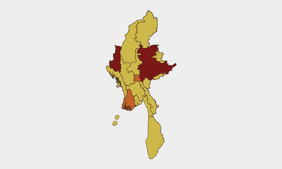
Shan State (risk 100) and Chin State (risk 81.2) remain the primary conflict hotspots, reflecting intense armed activity and resistance control of significant territory. However, Sagaing and Magway regions have emerged as secondary flash-points in the past 48 hours due to coordinated resistance operations and demonstrated defection momentum. Kachin State (risk 70) shows persistent vulnerability to KIA operations. Naypyitaw Union Territory (risk 73.8) remains at elevated risk due to proximity to command structures and ongoing security operations; Yangon and Mandalay (both risk 70) face secondary risks from civil unrest and potential supply-line disruption from the nationwide flooding event.
How GeoBit Would Assist
Security teams would employ AOI Monitoring & Early Warning for Sagaing, Magway, and Kachin to detect emerging resistance operations and defection patterns in near real-time. Conflict & Military capabilities (battle mapping, force-structure analysis) would track junta losses and morale degradation across regions. Environmental & Health and Routing & Network Analysis tools would monitor flood impact on critical supply routes and personnel movement corridors, enabling alternative planning for corporate operations and staff mobility.
7-Day Outlook
Resistance momentum in central Myanmar (Sagaing, Magway) is likely to sustain or intensify as defection rates indicate morale decline within junta ranks. Flooding will degrade junta logistics and restrict both military and civilian movement through the week. Regional diplomatic activity may continue without affecting on-ground security trajectory; no near-term ceasefire or significant operational pause is assessed.
Highest-Risk Areas — Ranked
| # | State / Region | Risk |
|---|---|---|
| 1 | Shan State | 100 |
| 2 | Chin | 81.2 |
| 3 | Ayeyarwady | 73.8 |
| 4 | Naypyitaw Union Territory | 73.8 |
| 5 | Tanintharyi Region | 70 |
| 6 | Sagaing Region | 70 |
| 7 | Kachin State | 70 |
| 8 | Wa State (Northern Region) | 70 |
| 9 | Magway | 70 |
| 10 | Mandalay | 70 |
| 11 | Rakhine | 70 |
| 12 | Yangon | 70 |
Sources
Previous Daily Briefs
A new Myanmar brief is written every day — each with its own risk map and downloadable CSV. Here's the last week; use the calendar to go further back.
📅 Browse every day by calendar →
Highlighted days have a brief. Tap a day for that day's map & analysis, or “csv” for that day's dataset ($5).
Atlas — our AI intelligence desk — emails them this snapshot personally. Nothing else, no list.