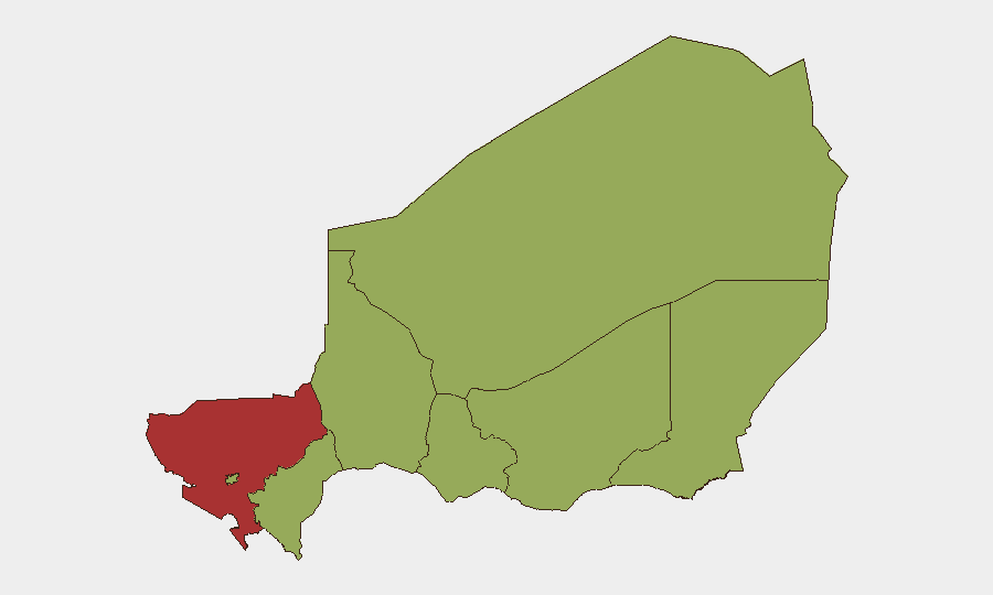
Situation Summary
Niger remains under persistent terrorist pressure, primarily in the Tillabéri Region and tri-border areas with Mali and Burkina Faso. The most recent corroborated major incident—a 17 July ambush near Téra that killed 16 soldiers—falls outside the current 24–48-hour window; follow-on security sweeps concluded by 19 July with no new discrete incidents reported in the past two days. The overall threat trajectory remains elevated but localized rather than escalating nationwide.
Key Developments
No new corroborated security incidents have been reported in Niger during the 21–23 July period. Multi-source monitoring (news wires, security briefs, and social media) shows no freshly reported attacks, arrests, civil unrest, or major travel disruptions in the last 48 hours.
*Background for operational context:* The 17 July Téra–Bankilaré ambush in Tillabéri Region killed 16 Niger Armed Forces soldiers and wounded 23; 15 attackers were also killed. Subsequent search-and-sweep operations by military units concluded by 19 July. The incident underscores persistent jihadist activity in the tri-border region, attributed to groups including ISSP, ISGS, and JNIM, and reinforces the designation of Tillabéri as a restricted military zone with movement controls for civilians and NGOs.
Highest-Risk Areas
Tillabéri Region (risk score 77.4) is the primary driver of Niger's composite threat ranking, accounting for the gap between the national score (68) and all other sub-national zones (47.4). The region's elevated risk reflects active insurgent operations, ambush patterns targeting military convoys, and IED use concentrated in the Téra–Doungouro–Bankilaré corridor and broader tri-border area. Agadez, Zinder, Diffa, and secondary zones (including Niamey) carry uniform moderate-to-high risk; Niamey's inclusion at 47.4 reflects broader regime-stability and crime considerations rather than active conflict. Operationally, any travel, resupply, or asset positioning in Tillabéri demands current military coordination and should assume restricted-zone protocols.
How GeoBit Would Assist
Corporate security and duty-of-care teams operating in Niger should leverage AOI (area-of-interest) monitoring and early-warning alerts on Tillabéri Region and the tri-border zone to detect ambush patterns, military movements, and checkpoint activity in near-real time. Conflict mapping and force-structure tracking provide granular visibility of ANP, military-unit positioning and ongoing operations, enabling route-planning and convoy-timing decisions. OSINT fusion across news, social media, and radio SIGINT captures jihadist messaging, recruitment, and tactical signaling before incidents manifest, supporting predictive risk assessment and personnel briefings.
7-Day Outlook
No significant escalation is forecast for the next seven days based on current pattern analysis, though the tri-border area will remain under active military operations and terrorist pressure. Routine security sweeps and counter-insurgency activity are likely to continue in Tillabéri; teams should anticipate temporary road closures, checkpoint increases, and operational delays. The risk of secondary ambushes or IED incidents in the region remains non-zero and should be treated as standing operational assumption through the planning horizon.
Highest-Risk Areas — Ranked
| # | State / Region | Risk |
|---|---|---|
| 1 | Tillabéri Region | 77.4 |
| 2 | Agadez Region | 47.4 |
| 3 | Zinder Region | 47.4 |
| 4 | Diffa Region | 47.4 |
| 5 | Niamey | 47.4 |
| 6 | Tahoua Region | 47.4 |
| 7 | Dosso Region | 47.4 |
| 8 | Maradi Region | 47.4 |
Sources
Previous Daily Briefs
A new Niger brief is written every day — each with its own risk map and downloadable CSV. Here's the last week; use the calendar to go further back.
📅 Browse every day by calendar →
Highlighted days have a brief. Tap a day for that day's map & analysis, or “csv” for that day's dataset ($5).
Atlas — our AI intelligence desk — emails them this snapshot personally. Nothing else, no list.