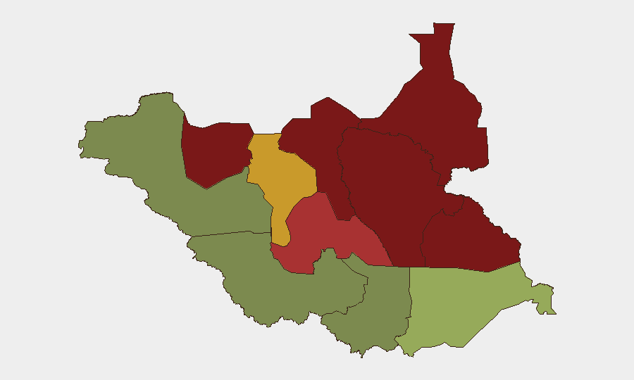
Situation Summary
South Sudan remains a high-threat operating environment, ranked #31 globally with a composite threat score of 65, driven primarily by ongoing armed conflict. As of 19–20 August 2026, the UN humanitarian coordinator reported that 36 aid workers and contractors have been killed since January—already exceeding the full 2025 toll—with more than 450 documented incidents of violence against humanitarian personnel and assets between January and July. The security posture has deteriorated markedly year-on-year, forcing international organizations to relocate operations from multiple areas and implement heightened movement restrictions for staff.
Key Developments
- Countrywide, 19 August 2026: UN humanitarian coordinator issued public statement documenting 36 aid-worker deaths since January 2026 and 450+ incidents of violence against humanitarian operations January–July, signaling sustained and elevated targeting of NGO and contractor personnel across multiple regions.
- Countrywide, 19–20 August 2026: Media amplification of UN warning that South Sudan remains among the world's most dangerous countries for aid workers; security incidents against humanitarian operations have doubled year-on-year, prompting active advisory to restrict movement and increase protective measures countrywide.
- Countrywide, 20 August 2026: Regional security advisory platforms maintain active monitoring status for South Sudan in Horn of Africa threat feed, confirming ongoing multi-sector security and conflict concerns as of date of brief.
- Countrywide (6–10 August escalation cluster): Prior week showed documented escalation targeting civilian pastoral communities, though no discrete follow-on incidents clearly verified for 16–20 August period.
*Note:* Available open-source reporting for the 48-hour window (19–20 August) does not surface location-specific attacks, ambushes, or unrest events with sufficient granularity to cite discrete incidents by location and time. Threat elevation is pattern-based and cumulative rather than driven by a single recent incident.
Highest-Risk Areas
Unity (risk 95), Jonglei (93), and Upper Nile (88) remain the three highest-risk states, collectively representing the core conflict zone and primary driver of the national threat score. These areas experience ongoing inter-communal violence, armed-group activity, and targeting of civilians and humanitarian infrastructure. Greater Pibor Administrative Area (87) and Northern Bahr el Ghazal (82) follow as secondary hotspots. By contrast, Central Equatoria (35) and Western Bahr el Ghazal (28)—which include or border the capital region—carry substantially lower threat profiles, reflecting greater state control and reduced active conflict intensity, though kidnapping and armed robbery remain present risks in peripheral areas.
How GeoBit Would Assist
Corporate security and duty-of-care teams operating in or traveling to South Sudan should employ AOI (Area-of-Interest) Monitoring & Early Warning to track real-time security developments in high-risk states, coupled with Intel Sweep and multi-language OSINT fusion to detect emerging incident patterns and NGO security alerts before they reach mainstream media. Routing & Network Analysis capabilities enable alternative journey planning to avoid known hotspots in Unity, Jonglei, and Upper Nile, while Conflict & Military force-structure tracking provides clarity on armed-group disposition and recent movements in strategic locations.
7-Day Outlook
South Sudan is expected to remain at elevated threat through the immediate week, with no indicators of de-escalation in core conflict zones. The documented targeting of aid operations is likely to persist, and the humanitarian operating environment will remain constrained. Organizations should expect continued movement restrictions and security incidents in northern and eastern regions, particularly Unity and Jonglei states.
Highest-Risk Areas — Ranked
| # | State / Region | Risk |
|---|---|---|
| 1 | Unity | 95 |
| 2 | Jonglei | 93 |
| 3 | Upper Nile | 88 |
| 4 | Greater Pibor Administrative Area | 87 |
| 5 | Northern Bahr el Ghazal | 82 |
| 6 | Lakes | 78 |
| 7 | Warrap | 72 |
| 8 | Ruweng Administrative Area | 68 |
| 9 | Eastern Equatoria | 52 |
| 10 | Western Equatoria | 38 |
| 11 | Central Equatoria | 35 |
| 12 | Western Bahr el Ghazal State | 28 |
Sources
Previous Daily Briefs
A new South Sudan brief is written every day — each with its own risk map and downloadable CSV. Here's the last week; use the calendar to go further back.
- August 18, 2026
- August 16, 2026
- August 14, 2026
- August 12, 2026
- August 11, 2026
- August 10, 2026
- August 9, 2026
📅 Browse every day by calendar →
Highlighted days have a brief. Tap a day for that day's map & analysis, or “csv” for that day's dataset ($5).
Atlas — our AI intelligence desk — emails them this snapshot personally. Nothing else, no list.