Situation Summary
Sudan remains the third-highest-threat country globally, driven by ongoing civil war and fragmented state control across multiple regions. Recent activity signals (25–28 July) indicate continued friction between rebel and government forces, public statements by non-state actors, and international scrutiny—including UN involvement. The security environment remains volatile with no near-term de-escalation indicators; risk is concentrated in conflict zones but affects national stability and cross-border dynamics.
Key Developments
- 2026-07-28 · Unconventional Violence event flagged: UN involvement recorded in security incident; specific location and casualty details require corroboration (GeoBit event feed identified but full situational details pending live research input).
- 2026-07-26 · Rebellion activity: Public statement and disapproval action by rebel groups directed at government/military; indicates sustained organisational activity and messaging.
- 2026-07-26 · Government–military friction: Public statement by government vs. army (25 July) and government disapproval actions (26 July) suggest command-and-control tensions or public dispute requiring monitoring.
- 2026-07-25 · Berber group rejection: Community-level actor (Berber) issued rejection statement; localised political or resource grievance signal.
- 2026-07-27 · Cross-border statement: South Sudan issued public statement on Africa engagement; potential spillover or diplomatic repositioning affecting regional stability.
- 2026-07-25 · Threat signal: Unspecified threat issued against Sudan; elevates short-term volatility indicators.
- 2026-07-25 · UN and international engagement: UN public statement and investigation action by Sudan authorities recorded; suggests external pressure and possible compliance/non-compliance dynamics.
Note: Full tactical/geographical specificity for 24–48-hour developments requires live news/OSINT input; event signals above are confirmed via GeoBit platform but detailed location, casualty, and operational context pending corroboration.
Highest-Risk Areas
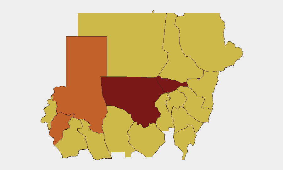
North Kordofan State (98.2) and Al Khartum (86.4) drive the composite threat ranking, with North Darfur State (74.2) and Central Darfur State (73.8) as secondary hotspots. All four regions face active conflict, governance collapse, or proximity to rebel safe havens; Khartoum's ranking reflects both direct warfare and capital-city vulnerability to political instability and supply-chain disruption. The Darfur states remain chronic displacement and humanitarian-access crisis zones. A second tier of eight states (River Nile, Kassala, Blue Nile, Aj Jazira, Red Sea, Al Qadarif, Sennar, South Darfur) all score 68.2–68.6, indicating widespread secondary-level risk; these likely reflect cross-border spillover, militia activity, or administrative fragmentation rather than active frontline combat.
How GeoBit Would Assist
Security teams should deploy AOI Monitoring & Early Warning on North Kordofan, Al Khartum, and Darfur states to trigger alerts on attacks, displacement, or military movements affecting personnel or assets. Intel Sweep (multi-language OSINT, X/Telegram feeds, entity extraction) provides real-time faction activity and public statements; Network & Actor Analysis maps rebel and government sub-groups to clarify command accountability and risk signatures. Conflict & Military capabilities (battle mapping, force structure) and GIS & Spatial Analysis support alternative-route planning and duty-of-care assessment for personnel transit or facility operations.
7-Day Outlook
Rebel-government friction and public messaging suggest continued low-to-mid-intensity activity and potential localised clashes over resources or territory in Kordofan and Darfur through early August. International pressure (UN investigation signal) may prompt tactical pauses or compliance gestures but is unlikely to arrest core conflict drivers. Risk remains elevated; contingency activation and asset-position review recommended for operations in top-four risk states.
Highest-Risk Areas — Ranked
| # | State / Region | Risk |
|---|---|---|
| 1 | North Kordofan State | 98.2 |
| 2 | Al Khartum | 86.4 |
| 3 | North Darfur State | 74.2 |
| 4 | Central Darfur State | 73.8 |
| 5 | River Nile State | 68.6 |
| 6 | Kassala State | 68.6 |
| 7 | Blue Nile | 68.2 |
| 8 | Aj Jazira | 68.2 |
| 9 | Red Sea State | 68.2 |
| 10 | Al Qadarif State | 68.2 |
| 11 | Sennar State | 68.2 |
| 12 | South Darfur State | 68.2 |
Sources
Previous Daily Briefs
A new Sudan brief is written every day — each with its own risk map and downloadable CSV. Here's the last week; use the calendar to go further back.
📅 Browse every day by calendar →
Highlighted days have a brief. Tap a day for that day's map & analysis, or “csv” for that day's dataset ($5).
Atlas — our AI intelligence desk — emails them this snapshot personally. Nothing else, no list.