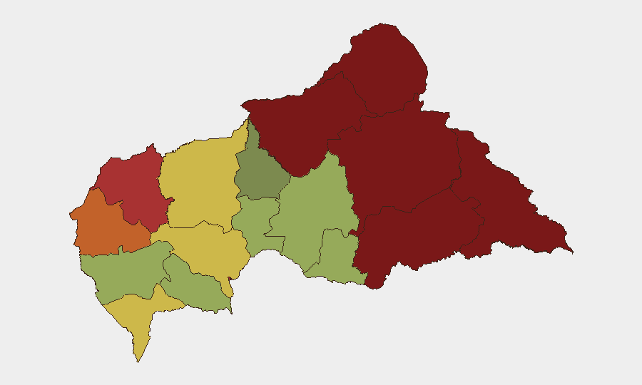
Situation Summary
Central African Republic remains in a fragile security equilibrium with composite threat ranking of 70 globally (#32). No discrete security incidents have been reported and verified in the last 24–48 hours via open-source channels; however, underlying drivers of conflict—armed group activity, intercommunal tensions, and weak state security capacity—persist across multiple prefectures. The situation is characterized by tactical calm punctuated by localized violence, with a recent upsurge in intercommunal clashes prompting civil-society calls for enhanced security measures around Bangui and key transit corridors.
Key Developments
- No verifiable incidents reported in last 24–48 hours. Open-source reporting for 23–24 July 2026 is sparse; available signals focus on general security posture and historical context rather than discrete, time-stamped events meeting recent-event criteria.
- UFDO security communiqué (22 July 2026, national level). Opposition coalition UFDO issued public statement calling for emergency security protocols, including systematic vehicle checks at strategic entry/exit points to Bangui, Damara, Boali, and Mbaïki, citing recent "regain de violence" (upsurge in violence) and calling for enhanced community-based territorial surveillance.
- Boali intercommunal clashes (Ombella-M'Poko, prior week, July 16–22). Localized clashes between community groups resulted in fatalities, injuries, and significant property damage; incident cited as trigger for UFDO's broader security appeal and reflects broader pattern of territorial and resource-based disputes in peri-urban zones around Bangui.
- Am Dafock border town situation remains fragile (Vakaga, post-30 June). Following the 30 June armed-group attack on this northern prefectural capital, subsequent reporting indicates stabilization but continued tension; displacement of thousands and damaged state/peacekeeping capacity in the zone persist as underlying vulnerabilities.
Highest-Risk Areas
Vakaga (risk 95) and Bamingui-Bangoran (risk 92) dominate the threat landscape, driven by proximity to porous borders, armed-group presence, and limited state administrative reach in the northeast. Haute-Kotto, Haut-Mbomou, and Mbomou (risks 88–82) along the southeastern border present similar drivers: cross-border militia activity, resource competition, and weak territorial control. Bangui itself (risk 78), while lower-ranked than frontier zones, remains a focal point of intercommunal tension, criminal activity, and political risk, particularly in informal settlements and around key access corridors where recent clashes have highlighted security gaps.
How GeoBit Would Assist
Security and duty-of-care teams should deploy AOI Monitoring & Early Warning capabilities on highest-risk prefectures (Vakaga, Bamingui-Bangoran, Bangui periphery) to detect tactical movement, gathering, or violence signals in near-real time. Intel Sweep and multi-language OSINT fusion across social media, local radio, and civil-society channels would provide earlier visibility into intercommunal tensions and armed-group repositioning than government or international reporting cycles. Routing & Network Analysis tools support alternative journey planning for personnel and supply movements, bypassing high-risk transit corridors identified in recent UFDO communiqués.
7-Day Outlook
No dramatic escalation is signaled in available data; however, the recent upsurge in intercommunal violence and civil-society pressure for enhanced security measures suggest underlying tensions remain volatile. Security teams should anticipate continued friction around Bangui access points and maintain heightened situational awareness in Ombella-M'Poko and neighboring prefectures through next week.
Highest-Risk Areas — Ranked
| # | State / Region | Risk |
|---|---|---|
| 1 | Vakaga | 95 |
| 2 | Bamingui-Bangoran | 92 |
| 3 | Haute-Kotto | 88 |
| 4 | Haut-Mbomou | 85 |
| 5 | Mbomou | 82 |
| 6 | Ouham-Pendé | 79 |
| 7 | Bangui | 78 |
| 8 | Nana-Mambéré | 75 |
| 9 | Sangha-Mbaéré | 68 |
| 10 | Ouham | 65 |
| 11 | Ombella-M'Poko | 62 |
| 12 | Kémo | 58 |
Sources
Previous Daily Briefs
A new Central African Republic brief is written every day — each with its own risk map and downloadable CSV. Here's the last week; use the calendar to go further back.
📅 Browse every day by calendar →
Highlighted days have a brief. Tap a day for that day's map & analysis, or “csv” for that day's dataset ($5).
Atlas — our AI intelligence desk — emails them this snapshot personally. Nothing else, no list.