Situation Summary
China's national security environment remains stable with no credible reports of large-scale civil unrest, terrorism, or regime-destabilizing incidents in the past 24–48 hours. However, active hazard-driven risks—including Typhoon Bavi impacts across coastal provinces, a major landslide and search-and-rescue operation in Chongqing, and elevated South China Sea maritime friction—are driving localized operational and travel disruptions. Authorities have intensified online surveillance and content censorship nationwide, creating elevated legal and information-environment risk for residents and international personnel who document or share sensitive social content.
Key Developments
- Pengshui County, Chongqing (July 20, 2026): Mountain collapse triggered search-and-rescue operations with 8 confirmed dead and 34 missing; over 1,100 residents evacuated. Road closures and emergency operations ongoing in southwestern Chongqing.
- Coastal China provinces (July 19–20, 2026): Typhoon Bavi (downgraded to severe tropical storm) prompted evacuation of more than 2 million people across eastern and northeastern coastal areas, with transport disruption and infrastructure stress expected to persist 72+ hours.
- South China Sea disputed waters (July 20, 2026): Philippines accused Chinese Coast Guard of striking a Philippine navy officer during a maritime boarding incident, escalating tensions in contested waters and raising safety risk for commercial and fishing vessels.
- Shandong Province/Vietnam cross-border (July 20, 2026): Chinese authorities took custody of a cybercrime suspect ("Pan") from a joint Chinese–Vietnamese operation, indicating active cross-border cybercrime enforcement and potential scrutiny on IT and telecom operations linked to Southeast Asia.
- Nationwide online platforms (mid-July ongoing): Authorities have significantly tightened surveillance and censorship of content documenting floods, labor disputes, wage protests, and rights-defense actions. Users face up to 10 days administrative detention, criminal charges, or account suspension for recording or sharing protest-related material.
Highest-Risk Areas
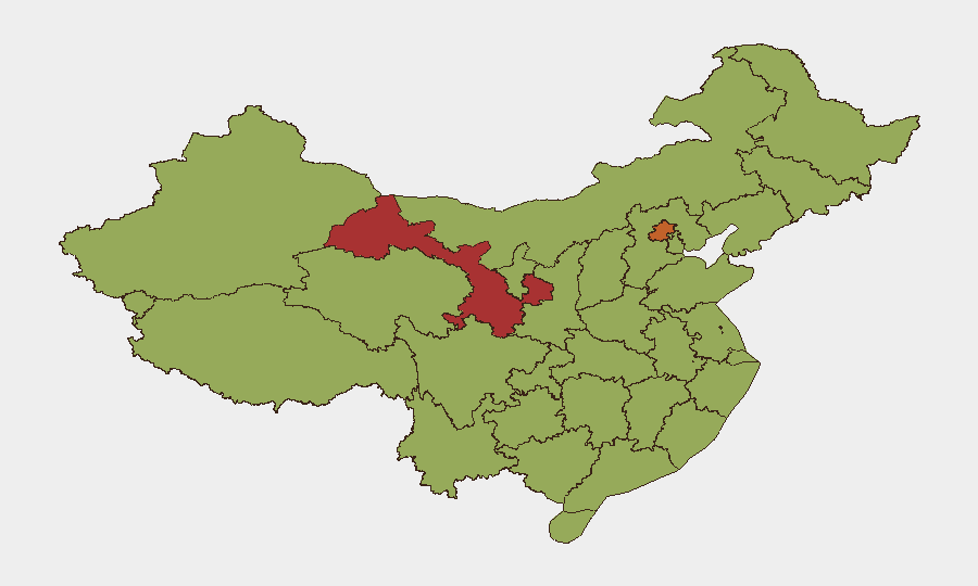
Gansu and Beijing carry the highest composite risk scores (76.8 and 75.3 respectively), followed by Guangdong, Fujian, and Shaanxi. However, current acute risk is concentrated in Chongqing (landslide and SAR operations, infrastructure disruption) and coastal provinces (Typhoon Bavi flooding and transport disruption). The South China Sea and maritime zones present elevated friction risk for vessels operating in disputed areas. Gansu and Beijing's elevated baseline scores likely reflect chronic security concerns (cross-border activity, political sensitivity in the capital) rather than imminent acute events; coastal and southwestern regions face immediate weather and terrain-driven hazard exposure.
How GeoBit Would Assist
Security teams should deploy AOI Monitoring & Early Warning on Chongqing and coastal provinces to track SAR progress, infrastructure restoration, and secondary hazard emergence (flooding, landslides). Maritime tracking and Network & Actor Analysis support real-time monitoring of South China Sea vessel movements and escalation signals in China–Philippines interactions. Multi-language OSINT fusion and sentiment & temporal analysis on Chinese social platforms enable early detection of restricted content trends and surveillance enforcement patterns, helping international personnel assess legal and reputational risk from online activity.
7-Day Outlook
Typhoon Bavi impacts should subside within 72 hours, but coastal transport and utility restoration will extend into late July. The Chongqing SAR operation is likely to persist 7–10+ days; secondary landslide risk remains elevated in affected zones. South China Sea maritime friction is expected to remain elevated but stable absent new direct confrontations; cross-border cybercrime enforcement activity will likely continue at current tempo.
Highest-Risk Areas — Ranked
| # | State / Region | Risk |
|---|---|---|
| 1 | Gansu | 76.8 |
| 2 | Beijing | 75.3 |
| 3 | Guangdong Province | 55.4 |
| 4 | Fujian | 53.1 |
| 5 | Shaanxi | 52.1 |
| 6 | Shanghai | 51.7 |
| 7 | Hainan Province | 51.3 |
| 8 | Jiangsu | 50.8 |
| 9 | Liaoning | 47.5 |
| 10 | Anhui | 47.5 |
| 11 | Jiangxi | 47.5 |
| 12 | Hubei | 47.3 |
Sources
Previous Daily Briefs
A new China brief is written every day — each with its own risk map and downloadable CSV. Here's the last week; use the calendar to go further back.
📅 Browse every day by calendar →
Highlighted days have a brief. Tap a day for that day's map & analysis, or “csv” for that day's dataset ($5).
Atlas — our AI intelligence desk — emails them this snapshot personally. Nothing else, no list.