Situation Summary
Iran faces an acute escalation cycle driven by sustained US military strikes on Iranian military infrastructure over the past 48 hours, with at least 80–90 targets struck across multiple provinces and casualty reports of 14 killed and 78 injured. Simultaneous incidents involving Iranian forces and commercial shipping in the Strait of Hormuz, combined with Iranian air-defense claims (including a downed MQ-9 drone), indicate active military engagement and heightened risk of unintended escalation. The geographic concentration of strikes on southern coastal and nuclear-adjacent provinces, coupled with civilian infrastructure damage (water facilities, port operations), signals sustained conflict momentum with no clear de-escalation signal as of 15 July 2026.
Key Developments
- Bushehr Province – explosions near nuclear power plant (14 July 2026). Multiple outlets report strikes at or near the Bushehr nuclear facility perimeter following US airstrikes, raising acute safety and infrastructure risk in Bushehr city and surrounding areas.
- Chabahar, Sistan and Baluchestan – port and IRGC facility strikes (14 July 2026). US airstrikes reported to have hit Chabahar port and IRGC-linked installations, disrupting maritime operations and threatening civilian port workers and nearby populations.
- Southern Gulf coastal corridor – multi-site explosions (14 July 2026). Blasts reported on Kharg Island, Qeshm Island, Sirik, and Bandar Abbas, directly affecting Iran's primary oil export infrastructure, shipping lanes, and coastal populations.
- Mahshahr, Khuzestan – civilian infrastructure strike (14 July 2026). One killed and four injured at an agricultural water pumping station following US strikes, demonstrating vulnerability of non-military civilian infrastructure to the current campaign.
- Strait of Hormuz – Iranian warning fire on commercial vessels and IRGC small-boat targeting (past 48 hours). Iranian forces reported to have fired on or near commercial shipping; simultaneous US strikes targeted IRGC coastal systems, producing significant reduction in transiting vessel traffic.
- IRGC air-defense claim – MQ-9 drone downing (14 July 2026). Iranian Revolutionary Guard sources claim successful engagement of a US MQ-9 reconnaissance drone over southern Iran, indicating active air-defense operations and ongoing risk of military incidents in Iranian airspace.
- Multi-province casualty toll (13–14 July 2026). Iran's health ministry reports 14 dead and 78 wounded across five provinces, with most casualties concentrated in Khuzestan, Bushehr, and Hormozgan.
Highest-Risk Areas
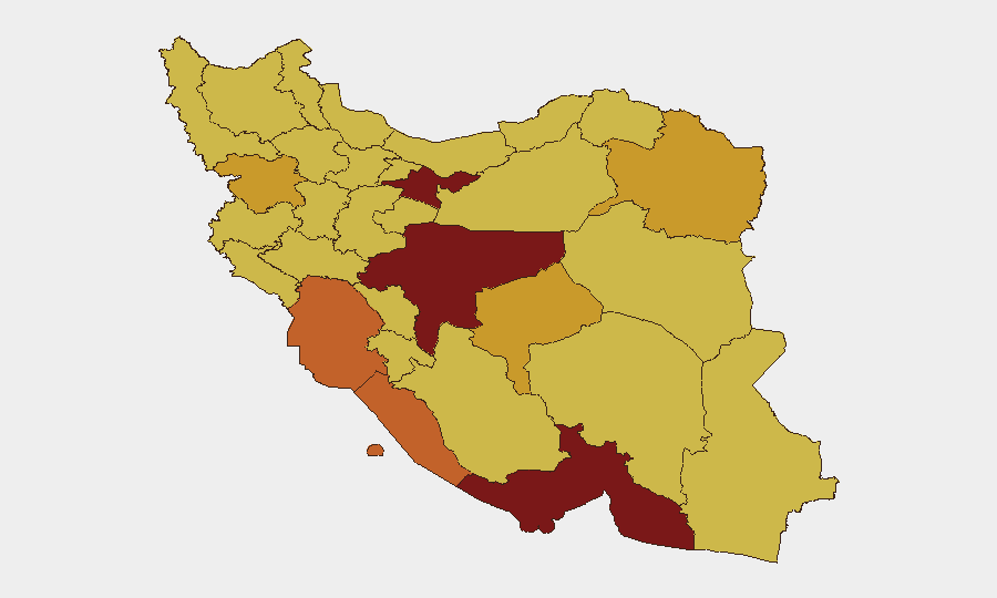
Tehran Province (risk 100) and Isfahan Province (risk 92) lead the national ranking due to political, administrative, and infrastructure concentration; however, the current acute threat is in the southern coastal belt, where Hormozgan (83.9), Bushehr (75.7), Khuzestan (73.5), and Sistan and Baluchestan (70.5) face direct strike impact, port closures, shipping disruption, and ongoing military activity. Nuclear-proximity risk in Bushehr and maritime choke-point exposure in Hormozgan amplify consequence severity, even if absolute event density currently concentrates in coastal provinces.
How GeoBit Would Assist
Security teams should deploy AOI Monitoring & Early Warning on Bushehr, Chabahar, Kharg Island, and the Strait of Hormuz corridor to detect follow-on strikes and incident clustering in near-real time. Maritime & Aviation tracking combined with Routing & Network Analysis enable alternative-route planning for supply chains and personnel movement bypassing Gulf ports and at-risk southern corridors. Conflict & Military battle mapping and Satellite & Imagery analysis provide damage assessment and force-posture monitoring to refine risk forecasts for specific facilities.
7-Day Outlook
Unless diplomatic intervention or ceasefire signals emerge in the next 48–72 hours, additional rounds of strikes are assessed as probable, with southern provinces and maritime zones remaining at elevated risk. Personnel and asset relocations from Bushehr, Chabahar, and Bandar Abbas should be considered contingency options; shipping rerouting away from the Strait is already reflected in market behavior.
Highest-Risk Areas — Ranked
| # | State / Region | Risk |
|---|---|---|
| 1 | Tehran Province | 100 |
| 2 | Isfahan Province | 92 |
| 3 | Hormozgan Province | 83.9 |
| 4 | Bushehr Province | 75.7 |
| 5 | Khuzestan Province | 73.5 |
| 6 | Razavi Khorasan | 72.6 |
| 7 | Kurdistan Province | 72.1 |
| 8 | Yazd Province | 71 |
| 9 | Sistan and Baluchestan Province | 70.5 |
| 10 | Kohgiluye and Buyer Ahmad Province | 70.4 |
| 11 | Gilan Province | 70.4 |
| 12 | Fars Province | 70.3 |
Sources
Previous Daily Briefs
A new Iran brief is written every day — each with its own risk map and downloadable CSV. Here's the last week; use the calendar to go further back.
📅 Browse every day by calendar →
Highlighted days have a brief. Tap a day for that day's map & analysis, or “csv” for that day's dataset ($5).
Atlas — our AI intelligence desk — emails them this snapshot personally. Nothing else, no list.