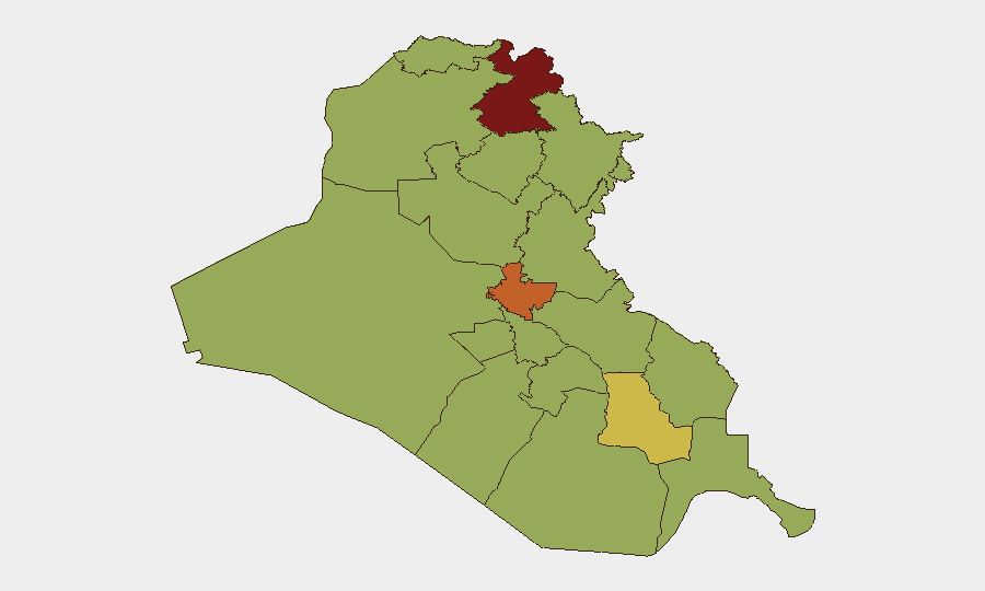
Situation Summary
Iraq remains at composite threat level 77 (global rank #15), driven primarily by insurgent activity and military strikes. The country is experiencing elevated cross-border tension tied to Iran–U.S. escalation, with reported drone and missile activity concentrated in the Kurdistan Region and northern governorates. Overall security conditions show no systemic improvement; localized violence persists across Baghdad and southern governorates, though reporting granularity for the immediate 24–48 hour window is limited.
Key Developments
Data limitation notice: Open-source reporting on Iraq does not contain high-confidence incident detail explicitly dated within the last 24–48 hours (July 25–27, 2026). The most recent multi-sourced incidents are clustered around July 23–24, 2026, as follows:
- Erbil Governorate, early morning July 24: Kurdish counter-terrorism and coalition sources reported interception of 5–8 explosive-laden drones over/near Erbil between approximately 04:19–05:25 local time; no casualties or infrastructure damage reported. Activity attributed to Iranian drone operations targeting U.S.-linked facilities in the Kurdistan Region.
- Sulaimaniyah vicinity, early morning July 24: Iranian Kurdish Komala party reported drone and rocket strikes on one of its camps near Sulaimaniyah, resulting in 8 killed and additional wounded; regional sources attribute the attack to Iran.
- Baghdad Governorate: GEOBIT event signals indicate small arms combat and gang-related physical assault within Baghdad as of July 25; specific location and casualty data not available.
- Kirkuk Air Base (K–1): A fire outbreak was reported at the base with cause and extent of damage under assessment; precise incident date not confirmed within the 24–48 hour window.
- Cross-border infrastructure: U.S. strikes in the Shalamcheh border area (Iran–Iraq border) reportedly caused casualties; Kuwait subsequently closed the Abdali border crossing after missile strikes, indicating wider regional transport disruption linked to Iran–U.S. tensions.
Highest-Risk Areas
Erbil Governorate (risk 84.2) and Baghdad Governorate (risk 75.3) are the primary drivers of national risk. Erbil's elevated score reflects ongoing drone and missile activity from Iran targeting U.S. and regional coalition facilities; Baghdad's score reflects persistent small arms violence, gang activity, and abduction incidents typical of the capital's criminality and militia presence. A secondary cluster of southern and central governorates (Dhi Qar, Al-Anbar, Babil, Wasit, Al-Qadisiyah, Maysan, Al-Basra, Al-Najaf, and Saladin) all register 54–62.3, suggesting distributed low-to-moderate risk rather than concentration in a single region outside the north and capital.
How GeoBit Would Assist
Security teams with personnel or assets in Iraq should employ AOI Monitoring & Early Warning for persistent watch over Erbil, Baghdad, and Kirkuk with alert thresholds set for drone activity, military strikes, and cross-border incidents. Conflict & Military capabilities (battle mapping, force-structure tracking) and Network & Actor Analysis enable identification of Iranian drone operators and militia supply chains. Routing & Network Analysis assists in real-time alternative-route planning around infrastructure damage and border closures, while multi-language OSINT and event-feed fusion (Intel Sweep) closes the reporting gap seen in the current 24–48 hour window by correlating Kurdish, Iraqi, and Iranian regional sources.
7-Day Outlook
Cross-border Iran–U.S. tensions are expected to sustain drone and missile activity in northern Iraq through early August, with Erbil, Sulaimaniyah, and Kirkuk remaining high-priority targets. Baghdad and southern governorates will likely see continued endemic violence (criminality, militia activity) absent major political or security force intervention. Risk of escalation or de-escalation hinges on broader U.S.–Iran diplomatic signals outside Iraq's direct control.
Highest-Risk Areas — Ranked
| # | State / Region | Risk |
|---|---|---|
| 1 | Erbil Governorate | 84.2 |
| 2 | Baghdad Governorate | 75.3 |
| 3 | Dhi Qar Governorate | 62.3 |
| 4 | Al-Anbar Governorate | 55 |
| 5 | Babil Governorate | 54.2 |
| 6 | Wasit Governorate | 54.2 |
| 7 | Al-Qadisiyah Governorate | 54.2 |
| 8 | Al-Muthanna Governorate | 54.2 |
| 9 | Maysan Governorate | 54.2 |
| 10 | Al-Basra Governorate | 54.2 |
| 11 | Al-Najaf Governorate | 54.2 |
| 12 | Saladin Governorate | 54.2 |
Sources
Previous Daily Briefs
A new Iraq brief is written every day — each with its own risk map and downloadable CSV. Here's the last week; use the calendar to go further back.
📅 Browse every day by calendar →
Highlighted days have a brief. Tap a day for that day's map & analysis, or “csv” for that day's dataset ($5).
Atlas — our AI intelligence desk — emails them this snapshot personally. Nothing else, no list.