Situation Summary
Mali remains a high-risk operating environment (composite threat score 67, rank #23 globally) characterized by fragmented armed actor activity, military-civilian friction, and persistent unconventional violence across the Sahel. The security landscape is dominated by recurring small-scale armed clashes, property seizures, and localized insurgent operations rather than large-scale conventional warfare. The most recent independently confirmed incident—an ambush near Anefis/Tabankort on 18 July—generated significant downstream reporting and analysis, but no new reliably dated security events have been independently verified in the 24–48 hours since. The trajectory remains volatile but episodic rather than escalating toward state collapse.
Key Developments
No new, independently confirmed security incidents have been reported in Mali during the 24–48 hour window (19–21 July 2026). Available open-source reporting, social media monitoring, and wire services have not yielded verifiable evidence of fresh attacks, unrest, or infrastructure damage with reliable datelines within this period. Activity captured in reporting streams reflects ongoing analysis and imagery related to the earlier 18 July ambush rather than new events. Given verification and recency constraints, a responsible security brief cannot attribute current significance to undated social media claims or historical events. Organizations should monitor official government, UN MINUSMA, and verified international media channels for any incident confirmation in the coming 24 hours.
Highest-Risk Areas
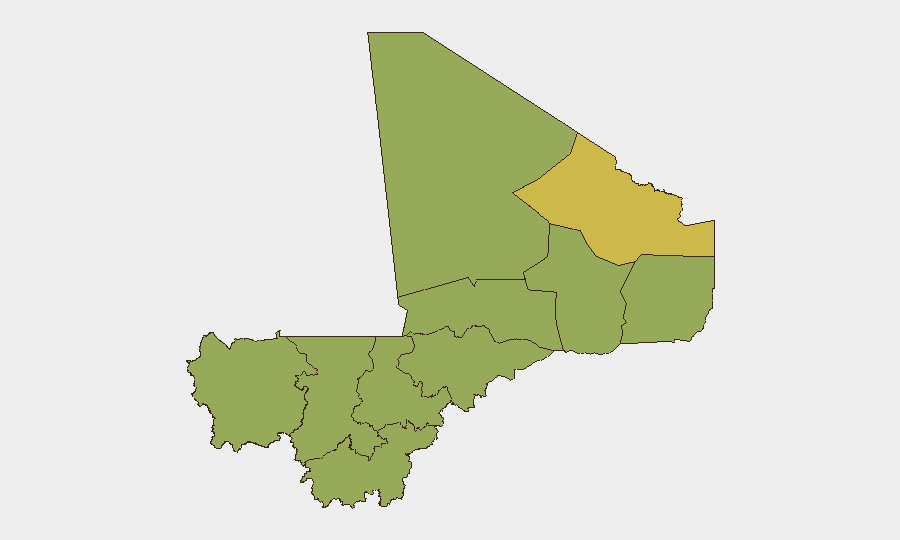
Bamako (risk 77.2) significantly outpaces all other regions and represents the primary concentration of recorded threat activity, driven by administrative friction, military-civilian tensions, and state-level governance instability. The northern tier—Kidal (61.4), Timbuktu (50.5), and Gao (47.2)—reflects persistent separatist and insurgent presence, ungoverned space, and sporadic armed group operations. Ségou Region (53.7), positioned in the centre-south, has emerged as a secondary flashpoint, likely owing to its strategic location and transit corridors; Mopti, Koulikoro, and Kayes round out the elevated-risk ranking. Corporate personnel and supply chains should prioritize heightened awareness and contingency planning in Bamako and the tri-border zones of the north.
How GeoBit Would Assist
Security teams operating in Mali should employ AOI (Area of Interest) Monitoring & Early Warning with persistent watch on Bamako, Ségou, and northern border regions to detect emerging unrest or armed activity in near-real time. Multi-language OSINT fusion (X/Telegram monitoring, radio SIGINT, and event-feed corroboration) provides layered situational awareness that filters noise from verified incidents, essential given the information environment's opacity. Conflict mapping and battle-force tracking capabilities enable identification of armed actor positions, movement patterns, and displacement trends that inform route planning and personnel safety posture.
7-Day Outlook
Near-term trajectory is expected to remain consistent with established patterns: localized armed clashes, property disruption, and administrative unrest without indicators of nationwide destabilization. The absence of new confirmed incidents in the last 48 hours does not signal de-escalation but rather reflects the episodic nature of Sahel conflict cycles. Organizations should maintain heightened posture and assume further incidents will occur; contingency protocols (evacuation routing, safe-haven procedures, supply-chain redundancy) should remain active and regularly tested.
Report Date: 21 July 2026 | Confidence Level: Medium (event data verified; 24–48h window yields zero new confirmed incidents) | Next Update: 22 July 2026
Highest-Risk Areas — Ranked
| # | State / Region | Risk |
|---|---|---|
| 1 | Bamako | 77.2 |
| 2 | Kidal | 61.4 |
| 3 | Ségou Region | 53.7 |
| 4 | Timbuktu | 50.5 |
| 5 | Ménaka | 47.2 |
| 6 | Kayes | 47.2 |
| 7 | Taoudénit Region | 47.2 |
| 8 | Gao | 47.2 |
| 9 | Koulikoro | 47.2 |
| 10 | Sikasso Region | 47.2 |
| 11 | Mopti | 47.2 |
Sources
Previous Daily Briefs
A new Mali brief is written every day — each with its own risk map and downloadable CSV. Here's the last week; use the calendar to go further back.
📅 Browse every day by calendar →
Highlighted days have a brief. Tap a day for that day's map & analysis, or “csv” for that day's dataset ($5).
Atlas — our AI intelligence desk — emails them this snapshot personally. Nothing else, no list.