Situation Summary
Myanmar remains in active armed conflict, with resistance forces executing coordinated multi-location attacks on military convoys and outposts while junta forces respond with airstrikes and tactical reinforcement deployments. The past 48 hours have seen confirmed casualty events across Magway, Sagaing, Kachin, and Rakhine, combined with a significant detention-escape incident in Sagaing and a heavy bombing campaign in Arakan. A strengthening monsoon system is now compounding ground insecurity with nationwide flood and landslide risk across ten states and regions. The conflict trajectory shows no signs of de-escalation; resistance momentum is measurable, and junta reinforcements indicate sustained operational intensity ahead.
Key Developments
- Saw Township, Magway Region (14 July): Resistance forces ambushed a military convoy, with confirmed reports of at least 10 junta soldiers killed and more than 20 defections from the column. The figures are corroborated across multiple resistance-aligned media channels.
- Mingin Township, Sagaing Region (14 July): Coordinated resistance attacks on both a junta ground column and naval convoy on the Chindwin River resulted in over 20 junta troops killed (including officers), approximately 15 wounded, and no reported resistance casualties. A follow-up arrest of the girlfriend of escaped SRF chairman Ko San Tin Htun suggests ongoing junta pursuit operations in the area.
- Hkawnglanghpu area, Kachin State (14 July): The Kachin Independence Army captured two junta outposts, degrading junta force positioning in northern Kachin. KIA-linked channels confirmed the seizures within 24 hours.
- Gwa Township, Rakhine State (13–14 July): The junta conducted a heavy airstrike campaign deploying jet fighters and Y-12 aircraft, dropping more than 50 bombs between approximately 22:00–22:55 on the night of 13 July. The operation indicates continued air-superiority use against resistance concentrations.
- Southern Chin State (Mindat and Kanpetlet areas, reported 13–14 July): The military regime is deploying nearly 1,000 reinforcement troops following heavy casualties and tactical setbacks against resistance forces. This buildup signals junta commitment to retake or hold key terrain despite mounting losses.
- Nationwide (14–15 July): A strengthening low-pressure system and strong southwest monsoon are generating heavy rainfall, flash-flood, landslide, and strong-wind warnings across Kachin, Sagaing, Mandalay, Bago, Tanintharyi, Shan, Chin, Rakhine, Karen, and Mon states. Travel disruption and infrastructure damage are anticipated.
- Maunghnitma Village, Mrauk-U Township, Rakhine State (reported 13 July): Over 500 residents face acute drinking-water shortage after floodwaters contaminated communal ponds with saltwater, forcing reliance on limited alternative sources.
Highest-Risk Areas
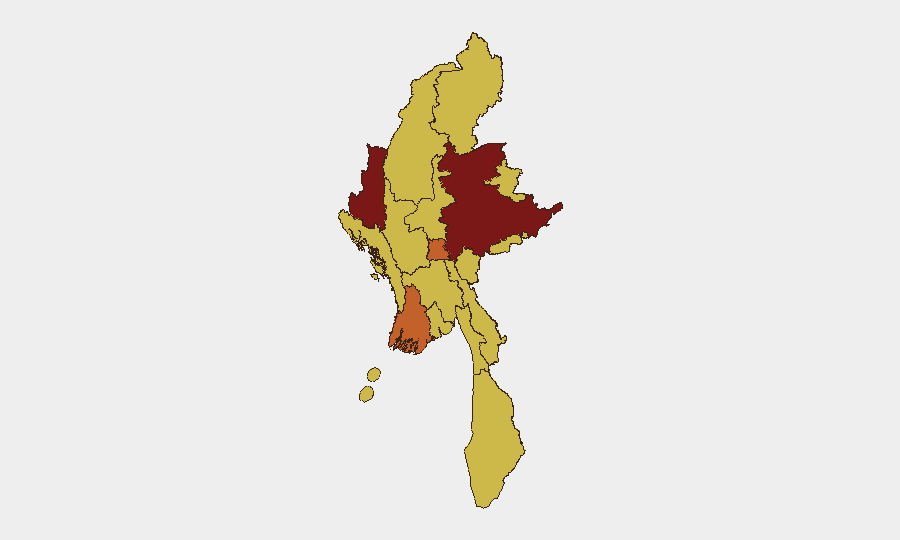
Shan State (risk 100) remains the single highest-threat zone, followed by Chin (81.2), Ayeyarwady, and Naypyitaw (both 73.8). However, the past 48 hours show active kinetic intensity concentrated in Sagaing, Magway, and Kachin—regions where resistance offensive operations and jutan reinforcement deployments are concurrent. Rakhine has elevated risk due to intensive airstrike activity and monsoon-driven infrastructure breakdown. Personnel and assets in Sagaing and Magway face immediate convoy and movement risk; those in Chin, Kachin, and Rakhine face both combat and weather-related disruption to supply chains, medical access, and personnel mobility.
How GeoBit Would Assist
Security teams should employ AOI Monitoring & Early Warning on Sagaing, Magway, Kachin, and Chin to detect future ambush indicators and reinforcement movements in real time. Conflict & Military battle mapping and force-structure tracking provide current junta and resistance disposition, casualty trends, and tactical momentum. Routing & Network Analysis identifies alternative supply and personnel movement corridors that avoid confirmed combat zones and flood-risk areas, while Environmental & Health monitoring tracks monsoon impacts on critical infrastructure and medical supply chains.
7-Day Outlook
Resistance momentum is likely to continue; the scale and coordination of recent attacks suggest operational planning is maturing. Junta reinforcement deployments to Chin and ongoing airstrikes indicate escalated commitment to high-casualty areas, risking further tactical reversals and defections. Monsoon-driven flooding over the next week will degrade road access, delay medical evacuation, and increase food-security and water-access risks across multiple regions, particularly in Chin, Sagaing, and Rakhine.
Highest-Risk Areas — Ranked
| # | State / Region | Risk |
|---|---|---|
| 1 | Shan State | 100 |
| 2 | Chin | 81.2 |
| 3 | Ayeyarwady | 73.8 |
| 4 | Naypyitaw Union Territory | 73.8 |
| 5 | Tanintharyi Region | 70 |
| 6 | Sagaing Region | 70 |
| 7 | Kachin State | 70 |
| 8 | Wa State (Northern Region) | 70 |
| 9 | Magway | 70 |
| 10 | Mandalay | 70 |
| 11 | Rakhine | 70 |
| 12 | Yangon | 70 |
Previous Daily Briefs
A new Myanmar brief is written every day — each with its own risk map and downloadable CSV. Here's the last week; use the calendar to go further back.
📅 Browse every day by calendar →
Highlighted days have a brief. Tap a day for that day's map & analysis, or “csv” for that day's dataset ($5).
Atlas — our AI intelligence desk — emails them this snapshot personally. Nothing else, no list.