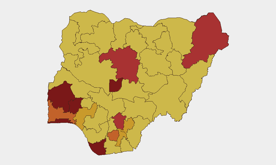
Situation Summary
Nigeria remains the fourth-highest-threat country globally (composite score 97), with insurgency as the primary driver across 361 tracked events. The past 24–48 hours have seen a sharp uptick in visible security operations: nationwide police sweeps across 11 states, Army anti-kidnapping clearances, and multi-agency counter-banditry actions in the Northwest and Middle Belt have resulted in multiple rescues, armed clashes, and reported bandit casualties. However, simultaneous mass-abduction incidents, communal violence, and targeted attacks on local leadership indicate that operational pressure has not yet broken criminal and insurgent capacity. The trajectory remains volatile and diffuse across rural and peri-urban zones.
Key Developments
- Lokoja LGA, Kogi State (31 July–1 August): Nigerian Army recovered multiple decomposing bodies and rescued five abduction victims during anti-kidnapping clearance sweeps of suspected bandit hideouts.
- Nationwide (11 states, 31 July–1 August): Nigeria Police Force reported major operational successes, including foiling bandit attacks, rescuing trafficked children, arresting suspected kidnappers and cultists, and recovering firearms, stolen vehicles, and livestock.
- Sokoto State, Rabaha LGA (31 July): Joint security operatives repelled a bandit attack; separately, police rescued 32 kidnap victims after bandits killed four persons in a fresh attack on Maikujera village in Rabah LGA.
- Katsina State (31 July–1 August): Joint security forces repelled a large-scale bandit attack; police reported attackers suffered "heavy casualties" and were forced to flee.
- Benue State, Otukpo & Kwande LGAs (31 July): At least 16 people killed in renewed attacks by suspected armed herdsmen on multiple communities; several others injured in farmer-herder conflict incidents.
- Taraba State, Lau LGA (31 July): Bandits killed five people, injured several, abducted a traditional ruler, and forced hundreds of residents to flee in a renewed communal attack.
- Zamfara State, multiple LGAs (31 July–1 August): Joint Zamfara Police and military operation rescued an abducted INEC staff member, repelled bandit attacks, and recovered hundreds of rustled cattle across Gummi, Talata Mafara, and Gusau LGAs.
Highest-Risk Areas
Lagos State (98.2), Oyo State (95.8), and the Federal Capital Territory (86.6) dominate the sub-national ranking, primarily driven by urbanization, population density, and criminal networks operating across transport hubs and commercial zones. However, the raw event data in the past 48 hours reveals that operational and casualty intensity is concentrated in the Northwest (Sokoto, Katsina, Zamfara), Middle Belt (Benue, Taraba, Kogi), and parts of the South-Southeast (Enugu, Imo, Ebonyi). Rural kidnap-for-ransom, farmer-herder violence, and banditry—not metro insurgency—are currently the most kinetic threats, suggesting risk scores in lower-ranked rural states may underweight current tactical intensity.
How GeoBit Would Assist
Corporate security teams should deploy AOI Monitoring & Early Warning on high-traffic corridors in Kogi, Sokoto, Katsina, Taraba, and Benue to detect renewed bandit staging or roadside incidents in real time. Network & Actor Analysis combined with OSINT fusion (X/Telegram monitoring, radio SIGINT) enables rapid identification of emerging gang coalitions and attack planning. Routing & Network Analysis can generate real-time alternative transport routes and community-safe corridors, reducing exposure to active conflict zones.
7-Day Outlook
Security operations are likely to intensify further over the next week as police and military seek to consolidate recent gains and prevent bandit regrouping. However, the dispersed geography of incidents—spanning six states—suggests that pressure will remain fragmented unless inter-agency coordination and intelligence-sharing improve. Mass-abduction risk remains elevated in rural Northwest and Middle Belt zones.
Highest-Risk Areas — Ranked
| # | State / Region | Risk |
|---|---|---|
| 1 | Lagos State | 98.2 |
| 2 | Oyo State | 95.8 |
| 3 | Federal Capital Territory | 86.6 |
| 4 | Osun State | 84.3 |
| 5 | Bayelsa State | 84.3 |
| 6 | Kaduna State | 78.3 |
| 7 | Borno State | 77 |
| 8 | Enugu State | 76.5 |
| 9 | Imo State | 75 |
| 10 | Ogun State | 73.7 |
| 11 | Ebonyi State | 71.8 |
| 12 | Abia State | 71.2 |
Sources
Previous Daily Briefs
A new Nigeria brief is written every day — each with its own risk map and downloadable CSV. Here's the last week; use the calendar to go further back.
📅 Browse every day by calendar →
Highlighted days have a brief. Tap a day for that day's map & analysis, or “csv” for that day's dataset ($5).
Atlas — our AI intelligence desk — emails them this snapshot personally. Nothing else, no list.