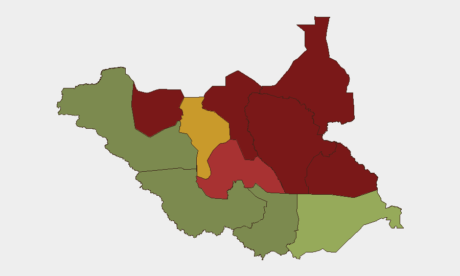
Situation Summary
South Sudan remains in active armed conflict with ceasefire violations and civilian violence spiking across multiple northern and central states as of 20–23 August. Approaching national elections are intensifying political tensions between forces aligned with President Salva Kiir and opposition leader Riek Machar, driving renewed clashes in Upper Nile, Jonglei, and Unity states. Violence targeting humanitarian personnel has accelerated sharply—36 aid workers and contractors killed since January 2026 alone—and armed groups are conducting abductions, attacks on IDP camps, and raids on civilian populations. The security environment is deteriorating rather than stabilizing, with no near-term de-escalation signals evident.
Key Developments
- Bentiu IDP Camp, Unity State (19 August): Violent clashes erupted following the arrest of a local spiritual leader, resulting in at least 5 deaths and 33 injuries. UNMISS has enhanced patrols but describes the camp's security posture as "highly fragile" as of 21 August, indicating unresolved tensions.
- Warrap State (mid-August, reported 23 August): Armed group attacks killed more than 60 civilians and injured 50, according to UNMISS condemnation issued 23 August. The incident remains current and reflects ongoing militia activity outside the primary conflict zones.
- Multi-state armed clashes (20–22 August): UN Commission reporting confirms resumption of coordinated fighting across Upper Nile, Jonglei, Unity, and parts of Western and Central Equatoria, with documented civilian deaths. This represents a fresh escalation, not isolated incidents.
- Bor Town, Jonglei State (mid-August): Six Ugandan truck drivers were abducted by armed men who seized their vehicles. The incident, highlighted in UN warnings of 21 August, signals ongoing targeting of cross-border commerce and civilian movement.
- Humanitarian worker fatalities (spike through August 22): 36 aid workers and contractors killed across South Sudan since January 2026, surpassing 2025's full-year total. This surge reflects both direct targeting and collateral exposure in active conflict zones.
- Ceasefire violations pattern (20–23 August): Hundreds of documented violations, with a concentrated spike in the 20–22 August window, primarily in Upper Nile, Jonglei, and Unity. Violations are attributed to forces from multiple political factions.
- Pre-election political environment (21–23 August assessment): UN Commission and associated reporting warn that heightened electoral competition is increasing the risk of atrocity crimes and large-scale violence between aligned armed groups.
Highest-Risk Areas
Unity, Jonglei, and Upper Nile states dominate the risk ranking (95, 93, and 88 respectively), driven by active armed conflict, ceasefire violations, and direct civilian targeting. Greater Pibor Administrative Area (87) and Northern Bahr el Ghazal (82) show similarly acute threats stemming from armed group activity and inter-communal violence. In contrast, Central Equatoria (35) and Western Bahr el Ghazal (28)—which include Juba and other urban centers—carry substantially lower risk, though they remain subject to occasional clashes and criminal activity. Risk correlates strongly with distance from state capitals and presence of armed factions; remote areas with minimal state authority present the highest danger to corporate and humanitarian operations.
How GeoBit Would Assist
Security teams should employ AOI Monitoring & Early Warning on high-risk states (Unity, Jonglei, Upper Nile) to detect ceasefire violations and armed movements in real time, coupled with Intel Sweep and OSINT (X, Telegram, radio SIGINT) to track faction communications and attack warnings. Routing & Network Analysis would enable identification of safer transit corridors and advance warning of checkpoints or militia positions affecting supply chains and personnel movement. Conflict & Military force-structure and Network & Actor Analysis capabilities help teams understand which armed groups control which territories and predict escalation vectors tied to electoral timelines.
7-Day Outlook
Ceasefire violations and localized clashes are expected to persist or intensify as electoral competition heightens and opposition and government forces maneuver ahead of polling. Humanitarian and cross-border logistics will remain under threat, particularly in Jonglei and Upper Nile. No significant de-escalation or security improvement is anticipated in the next 7 days; personnel and asset security protocols should remain at elevated status, with contingency withdrawal plans current for Unity, Jonglei, and Upper Nile operations.
Highest-Risk Areas — Ranked
| # | State / Region | Risk |
|---|---|---|
| 1 | Unity | 95 |
| 2 | Jonglei | 93 |
| 3 | Upper Nile | 88 |
| 4 | Greater Pibor Administrative Area | 87 |
| 5 | Northern Bahr el Ghazal | 82 |
| 6 | Lakes | 78 |
| 7 | Warrap | 72 |
| 8 | Ruweng Administrative Area | 68 |
| 9 | Eastern Equatoria | 52 |
| 10 | Western Equatoria | 38 |
| 11 | Central Equatoria | 35 |
| 12 | Western Bahr el Ghazal State | 28 |
Sources
Previous Daily Briefs
A new South Sudan brief is written every day — each with its own risk map and downloadable CSV. Here's the last week; use the calendar to go further back.
- August 22, 2026
- August 20, 2026
- August 18, 2026
- August 16, 2026
- August 14, 2026
- August 12, 2026
- August 11, 2026
📅 Browse every day by calendar →
Highlighted days have a brief. Tap a day for that day's map & analysis, or “csv” for that day's dataset ($5).
Atlas — our AI intelligence desk — emails them this snapshot personally. Nothing else, no list.