Situation Summary
Sudan remains in active civil war between the Sudanese Armed Forces (SAF) and the Rapid Support Forces (RSF), with composite threat ranking at #5 globally. Ground control is shifting in central Sudan, particularly along the Omdurman–El Obeid corridor in North Kordofan, where recent military operations have announced territorial gains but face continued aerial and drone counterattacks. Civilian infrastructure—markets, displaced-person camps, and main supply routes—remain under direct threat from both conventional fire and aerial strikes. The conflict trajectory shows no de-escalation signals; frontline volatility and cross-factional drone activity are expected to persist.
Key Developments
- North Kordofan export highway secured (July 26, 2026, announced): SAF and joint force announced recapture of the main Omdurman–El Obeid highway and five localities (Bara, Um Sayala, Um Garfa, Jabrat al-Sheikh, Al-Baraka) following two days of heavy fighting with RSF. High risk of renewed clashes, roadblocks, and indirect fire on the corridor remains.
- El Obeid drone strikes (July 26, 2026): RSF-aligned drone strikes hit El Obeid shortly after SAF's highway recapture announcement, confirming ongoing aerial threat to the North Kordofan capital despite ground-level military gains.
- Civilian market strike, Ar Rahad (late July 2026, reported July 24): Drone strike on a market in Ar Rahad, North Kordofan, killed at least two children and injured six others (ages 6–14), plus four adults killed and 20+ injured. Pattern consistent with sustained targeting of civilian civilian gathering points.
- Blue Nile drone strike on displaced persons (July 23, 2026): Sudanese army drone struck a gathering of displaced persons in the Badia area, Blue Nile State, causing significant civilian casualties including women and children. Indicates SAF drone operations in secondary conflict zones.
- RSF small-arms attack, West Kordofan (reported July 24, 2026): RSF patrol opened fire on civilian vehicle near Saq al-Jamal, west of Al-Nuhud, West Kordofan State, killing a six-year-old and critically injuring his brother. Reflects sporadic RSF presence and arbitrary violence on rural routes.
- UN Security Council warning, El Obeid (late July 2026): UNSC statement highlighted El Obeid as flashpoint, reinforcing international assessment of the city as a critical flashpoint for both SAF and RSF operations.
Highest-Risk Areas
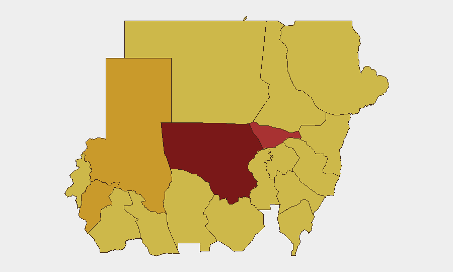
North Kordofan State (97.9 risk) dominates the threat landscape due to active frontline operations, drone activity, and displacement of civilians; the Omdurman–El Obeid highway is a primary military axis and remains volatile despite recent SAF gains. Al Khartum (78.4), though lower-ranked, faces ongoing risk from drone strikes and indirect fire on military and civilian infrastructure. Central Darfur (71.8) and North Darfur (71.6) show sustained displacement and localized armed activity; Blue Nile (67.9) and White Nile (68.1) see both SAF and RSF operations. Secondary risk states—Red Sea, Kassala, Sennar, and Aj Jazira—carry comparable threat scores (67.9), reflecting either strategic importance or ongoing paramilitary/RSF activity.
How GeoBit Would Assist
AOI Monitoring & Early Warning enables real-time tracking of the North Kordofan and Blue Nile conflict zones with alerts for new drone strikes, clashes, or displacement events. Battle Mapping and Force Structure analysis clarifies SAF/RSF control lines and likely next operations. Routing & Network Analysis identifies safer alternative routes for personnel and supply around active frontlines; Conflict OSINT and multi-language feed fusion corroborate fragmentary reports and detect emerging threats before they escalate.
7-Day Outlook
Frontline volatility in North Kordofan will likely persist as RSF attempts to recapture the Omdurman–El Obeid highway or reinforce secondary positions; SAF drone strikes on rear-area civilian sites are expected to continue. Displacement and humanitarian crisis conditions will worsen, increasing risk to NGO and corporate operations in secondary cities (El Obeid, Blue Nile localities). No ceasefires or diplomatic breakthroughs are signaled; travel and operations in North Kordofan, Blue Nile, and West Kordofan should be considered high-risk or suspended until conditions shift.
Highest-Risk Areas — Ranked
| # | State / Region | Risk |
|---|---|---|
| 1 | North Kordofan State | 97.9 |
| 2 | Al Khartum | 78.4 |
| 3 | Central Darfur State | 71.8 |
| 4 | North Darfur State | 71.6 |
| 5 | White Nile | 68.1 |
| 6 | Blue Nile | 67.9 |
| 7 | River Nile State | 67.9 |
| 8 | Aj Jazira | 67.9 |
| 9 | Red Sea State | 67.9 |
| 10 | Al Qadarif State | 67.9 |
| 11 | Kassala State | 67.9 |
| 12 | Sennar State | 67.9 |
Sources
Previous Daily Briefs
A new Sudan brief is written every day — each with its own risk map and downloadable CSV. Here's the last week; use the calendar to go further back.
📅 Browse every day by calendar →
Highlighted days have a brief. Tap a day for that day's map & analysis, or “csv” for that day's dataset ($5).
Atlas — our AI intelligence desk — emails them this snapshot personally. Nothing else, no list.