Situation Summary
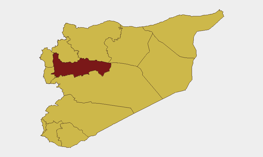
Syria remains the 7th highest-risk country globally (composite threat score 96), driven by active conflict across multiple fronts and 163 tracked security events. The past 48 hours reflect compounded infrastructure failures, cross-border smuggling incidents, counter-terrorism sweeps, and traffic-related casualties that underscore fragmented state control and persistent hazards for personnel and logistics. Hama Governorate carries the highest sub-national risk (97.3), while Damascus, despite government presence, remains under elevated threat following recent terrorist attacks near the capital.
Key Developments
- Al-Tanf border crossing, Syria–Iraq border (July 16 seizure; ongoing July 19–20): Syrian authorities seized an advanced weapons shipment concealed in an oil-tanker truck, reportedly containing long-range missiles, rockets, guided anti-tank systems, and drones allegedly destined for Hezbollah in Lebanon. Iraqi authorities announced a formal investigation, making this an evolving cross-border security and transit-corridor risk.
- Damascus and multiple governorates (July 19–20, ongoing): Counter-terrorism operations and security sweeps continue across Damascus city and countryside following recent terrorist attacks near the capital, generating elevated checkpoint density, raids, and potential movement restrictions for travelers.
- Nationwide infrastructure failures (July 20 reported): Civil defense documented 5 deaths and additional injuries across multiple governorates within a 24-hour period due to 174 fires and road-traffic accidents, signaling acute infrastructure and emergency-response vulnerabilities.
- Masayefra road, eastern Daraa Governorate (July 20 reported): A vehicle overturned on secondary roads in southern Syria, injuring 11 workers and highlighting hazards on eastern Daraa's secondary transport network.
- Al-Darbasiyah, Hasakah Governorate (ongoing through July 19–20): A fuel shortage has triggered multi-day power outages affecting basic services in northeastern Syria, now in its third day, complicating logistics and local operations.
- Euphrates river crossing, Deir ez-Zor Governorate (July 19, preceding 24 hours): A ferry sinking resulted in six fatalities, underscoring safety risks on informal or poorly regulated river crossings in eastern Syria.
- National road network (July 19, preceding 24 hours): Traffic authorities reported 1 fatality and 27 injuries across 19 accidents on inter-city routes, illustrating sustained road-safety exposure.
Highest-Risk Areas
Hama Governorate (risk 97.3) drives the highest composite risk, reflecting sustained active conflict and military operations. Damascus (77.7), despite government-seat status, ranks second due to recent terrorist attacks and intensive counter-terrorism sweeps that restrict movement and increase checkpoint exposure. Aleppo, Idleb, and Deir ez-Zor (all 67.3–69.5) carry elevated conventional and unconventional violence risk. Collectively, these areas account for overlapping military operations, counter-insurgency activity, and infrastructure collapse that compound duty-of-care exposure for corporate assets and personnel.
How GeoBit Would Assist
Teams with Syria exposure should leverage AOI Monitoring & Early Warning to track real-time developments in high-risk governorates (Hama, Damascus, Deir ez-Zor) with automated alerting. Routing & Network Analysis capabilities enable identification of alternative transport corridors and crossing points that avoid active conflict zones and checkpoint-heavy areas. Conflict & Military tracking combined with OSINT fusion (X/Twitter, Telegram, agency feeds) provides early warning of military movements and counter-terrorism operations that could disrupt personnel or supply-chain operations.
7-Day Outlook
Counter-terrorism sweeps in Damascus and surrounding areas will likely persist, maintaining elevated checkpoint and movement-restriction risk through the near term. Hama Governorate and eastern Syria (Deir ez-Zor, Hasakah) are expected to remain volatile; fuel and power crises in Hasakah may worsen logistics and inflate secondary-accident risk on regional roads. Cross-border smuggling tensions at al-Tanf and related friction points may trigger additional security cordons affecting Syrian transit corridors.
Highest-Risk Areas — Ranked
| # | State / Region | Risk |
|---|---|---|
| 1 | Hama Governorate | 97.3 |
| 2 | Damascus Governorate | 77.7 |
| 3 | Aleppo Governorate | 69.5 |
| 4 | Idleb Governorate | 67.6 |
| 5 | Deir ez-Zor Governorate | 67.6 |
| 6 | Lattakia Governorate | 67.3 |
| 7 | Tartus Governorate | 67.3 |
| 8 | UNDOF | 67.3 |
| 9 | Al-Quneitra Governorate | 67.3 |
| 10 | Dar'a Governorate | 67.3 |
| 11 | Ar-Raqqa Governorate | 67.3 |
| 12 | Homs Governorate | 67.3 |
Sources
Previous Daily Briefs
A new Syria brief is written every day — each with its own risk map and downloadable CSV. Here's the last week; use the calendar to go further back.
📅 Browse every day by calendar →
Highlighted days have a brief. Tap a day for that day's map & analysis, or “csv” for that day's dataset ($5).
Atlas — our AI intelligence desk — emails them this snapshot personally. Nothing else, no list.