Situation Summary
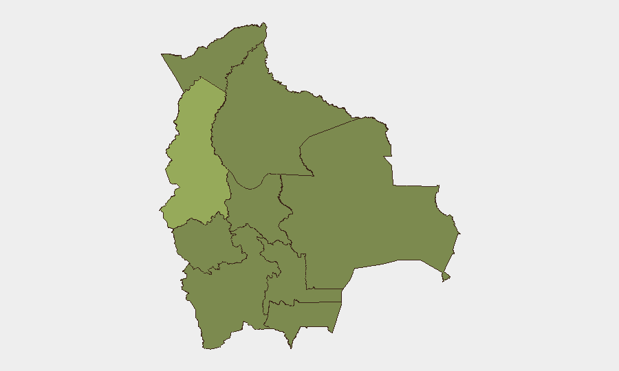
Bolivia remains at moderate security risk (#42 globally, composite score 38) under a national state of emergency declared 20 June 2026 to address protest-related roadblocks and civil unrest. La Paz significantly outranks other departments in risk (56.5 vs. next-highest Tarija at 35.1), reflecting concentrated tension around the capital and El Alto. Open-source reporting for the immediate 24–48 hour window (25–27 July) does not yield discrete, multi-source-confirmed security incidents; however, underlying risk drivers—roadblocks, protest activity, and expanded security-force authority—remain active and volatile.
Key Developments
Limitation: Genuine discrete incidents from 25–27 July 2026 with specific locations and timestamps cannot be reliably verified from available open sources. GeoBit's event-signal database shows tagged activity (rejection by authorities, military movement, arrests, territory occupation, public statements) on 25–27 July, but without corroborating web reporting, specific incident details cannot be attributed to precise locations or times with confidence.
Risk Continuity (since 20 June): National state of emergency remains in force, granting police and military expanded blockade-clearance powers. Recurring protest activity, roadblocks, and clashes with security forces remain reported across La Paz, El Alto, Chapare (Cochabamba), and Santa Cruz departments. Airport access and inter-departmental movement continue subject to disruption. Chapare region (Cochabamba) remains under strong travel advisory due to crime and security incidents.
Judicial/Security Development (21 July): Investigations into recruitment of Bolivian nationals for foreign military service (Russia) highlight broader security and human-trafficking concerns, though this is a transnational judicial matter rather than a domestic incident.
Highest-Risk Areas
La Paz dominates the risk landscape (56.5), more than 1.6 times higher than Tarija (35.1) and 2× higher than all other departments. This reflects the concentration of political authority, protest activity, institutional clashes, and security-force operations in and around the capital and El Alto. Tarija's secondary ranking (35.1) warrants monitoring but remains significantly lower in absolute terms. All other departments cluster between 26.5–27.1, suggesting more uniform baseline risk outside the capital corridor. Organizations with personnel or assets in La Paz face substantially elevated exposure to roadblocks, demonstrations, and potential security-force actions.
How GeoBit Would Assist
Security teams should deploy AOI Monitoring & Early Warning on La Paz, El Alto, and Chapare to track emerging protest activity and roadblock placement in real time. Intel Sweep and X/Twitter & Telegram OSINT (with multi-language support) can capture ground-level civil-unrest signals, route disruptions, and security-force movements faster than conventional news cycles. Routing & Network Analysis enables duty-of-care teams to pre-plan alternative travel and supply routes should primary corridors close. Sentiment & Temporal Analysis on regional social media can signal escalation risk 12–36 hours ahead of major protests.
7-Day Outlook
The state of emergency and underlying protest drivers show no signs of rapid resolution. Security-force operations to clear blockades and suppress demonstrations will likely continue, creating recurring 24–48 hour windows of elevated risk. Personnel movements within La Paz, El Alto, and along inter-city corridors should assume periodic disruption and plan logistics accordingly.
Highest-Risk Areas — Ranked
| # | State / Region | Risk |
|---|---|---|
| 1 | La Paz | 56.5 |
| 2 | Tarija | 35.1 |
| 3 | Santa Cruz | 27.1 |
| 4 | Potosí | 26.5 |
| 5 | Pando | 26.5 |
| 6 | Beni | 26.5 |
| 7 | Oruro | 26.5 |
| 8 | Cochabamba | 26.5 |
| 9 | Chuquisaca | 26.5 |
Previous Daily Briefs
A new Bolivia brief is written every day — each with its own risk map and downloadable CSV. Here's the last week; use the calendar to go further back.
📅 Browse every day by calendar →
Highlighted days have a brief. Tap a day for that day's map & analysis, or “csv” for that day's dataset ($5).
Atlas — our AI intelligence desk — emails them this snapshot personally. Nothing else, no list.