Situation Summary
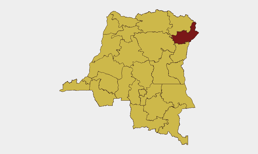
DR Congo remains the 9th-highest global threat environment, driven primarily by active insurgency and armed group activity across multiple provinces. The eastern conflict zone (North Kivu, South Kivu, Ituri) continues to see combat between M23-aligned forces, local militias, and the Armed Forces of the Democratic Republic of Congo (FARDC), with no resolution trajectory evident. Current open-source reporting shows a data gap for discrete, time-stamped incidents in the last 24–48 hours; however, the underlying threat landscape—characterized by armed clashes, militia activity, and civil unrest—remains structurally elevated and persistent.
Key Developments
Data Limitation Notice: Open-source security monitoring, including GeoBit feeds, social media intelligence, and professional analyst bulletins, currently lacks reliably verified, location-specific incidents for DR Congo dated 23–24 July 2026. Recent signals flagged on the GeoBit platform (property seizure/damage, disapproval statements, military force actions) are catalogued but lack discrete time-stamps and geographic pinning sufficient for operational reporting. Teams should treat the following as structural risk context rather than acute developments:
- Ituri Province (Risk 96.7): Ongoing low-level combat between FARDC and non-state armed groups; no major escalation documented in the last 48 hours, but persistent threat to movement and supply chains.
- Kinshasa (Risk 67.7): Worker disapproval signals and public statements logged; civil discontent around service delivery and security response remains a chronic flashpoint; no specific incident location or timestamp available for 24–25 July.
- Eastern Border (North Kivu/Ituri): Conventional military operations continue; recent signals reference FARDC vs. Uganda activity, likely cross-border posturing rather than major engagement, but exact location and timing unverified in last 24 hours.
- Broader Northern Provinces (Équateur, Mongala, Tshopo, etc.): Clustered at risk 66.7; these regions show chronic armed group presence and militia fragmentation; no acute incidents confirmed for the reporting window.
Highest-Risk Areas
Ituri dominates the risk landscape at 96.7, driven by active insurgency, militia proliferation, and FARDC counter-operations with limited capacity for civilian protection. Kinshasa's rank (67.7) reflects political and social instability—worker discontent, public statements of disapproval, and state fragility—rather than armed conflict. The remaining northern provinces (Équateur, Mongala, Nord-Ubangi, Tshopo, Tshuapa, Upper and Lower Uele) share equivalent risk (66.7) due to armed group presence, weak state control, and illicit activity; North Kivu, though not explicitly ranked in the top tier here, remains operationally critical given M23 and FARDC engagement. Risk concentration in the east and north reflects both active conflict and institutional capacity gaps.
How GeoBit Would Assist
Security teams should deploy AOI Monitoring & Early Warning on Ituri, North Kivu, and Kinshasa to capture emerging incidents, militia movements, and state action in near-real time. OSINT Fusion (X/Twitter, local media, radio SIGINT) combined with Network & Actor Analysis will maintain visibility on armed group posture and military positioning despite current open-source reporting gaps. Routing & Network Analysis supports alternative journey planning for personnel and assets in high-risk provinces, mitigating exposure to active conflict zones.
7-Day Outlook
No significant de-escalation is expected in the eastern conflict or northern militia activity over the next week. Kinshasa civil unrest may remain episodic. Monitoring for cross-border military activity (FARDC–Uganda) and any M23 repositioning will be critical; teams should prepare for potential access restrictions and supply-chain delays in affected provinces.
Highest-Risk Areas — Ranked
| # | State / Region | Risk |
|---|---|---|
| 1 | Ituri | 96.7 |
| 2 | Kinshasa | 67.7 |
| 3 | Maniema | 66.7 |
| 4 | Sud-Ubangi | 66.7 |
| 5 | Équateur | 66.7 |
| 6 | Nord-Ubangi | 66.7 |
| 7 | Mongala | 66.7 |
| 8 | Lower Uele | 66.7 |
| 9 | Tshopo | 66.7 |
| 10 | Tshuapa | 66.7 |
| 11 | Upper Uele | 66.7 |
| 12 | North Kivu | 66.7 |
Sources
Previous Daily Briefs
A new DR Congo brief is written every day — each with its own risk map and downloadable CSV. Here's the last week; use the calendar to go further back.
📅 Browse every day by calendar →
Highlighted days have a brief. Tap a day for that day's map & analysis, or “csv” for that day's dataset ($5).
Atlas — our AI intelligence desk — emails them this snapshot personally. Nothing else, no list.