Situation Summary
Iran faces an acute multi-front security crisis as of 18 July 2026, marked by sustained U.S. military strikes across southern and central provinces, internal military arrests, and explicit Iranian threats/military posturing toward regional actors. Over the past 48 hours, coordinated U.S. airstrikes have targeted naval, coastal, and air infrastructure across at least eight locations—from Ahvaz and Bandar Abbas to Qeshm Island and Semnan Airport—resulting in confirmed casualties, civilian displacement, and damage to dual-use facilities. The IRGC has responded with closure declarations for the Strait of Hormuz and reported attacks on commercial shipping, escalating regional maritime risk significantly.
Key Developments
- Ahvaz, Khuzestan Province (16–17 July): U.S. airstrikes forced emergency evacuation of a children's cancer hospital due to blast damage and safety concerns, compounding civilian-sector disruption in the province.
- Bandar Abbas, Hormozgan Province (16–17 July): Multiple U.S. strikes reported on IRGC positions, coastal radar, and anti-ship missile systems; residents confirmed multiple explosions across the city.
- Qeshm Island, Strait of Hormuz (16–17 July): Over 10 projectiles struck military and maritime infrastructure on the island; attacks consistent with U.S. targeting of Iran's Hormuz control apparatus.
- Chabahar & Konarak, Sistan and Baluchestan (16–17 July): Local officials confirmed strikes on naval military zone in two stages, with at least two explosions in Konarak during coordinated U.S. operations.
- Mahshahr, Khuzestan (16–17 July): U.S. strike on agricultural water pumping station killed one guard and injured four others, indicating civilian infrastructure now directly impacted.
- IRGC Strait of Hormuz Closure Declaration (18 July): IRGC formally reiterated closure of the Strait to all transiting vessels and claimed strike on a commercially-routed vessel, extending pattern of shipping attacks.
- Khandab & Semnan Airport (16–17 July): Outskirts of Khandab struck by reported enemy projectiles; Semnan Airport hit by projectile with infrastructure damage but no casualties reported.
- Regional Threat Escalation (18 July): Mexico threats against Iran, U.S. conventional military force declarations, and Iranian military posturing toward Jordan and Qatar signal widening diplomatic/military tension.
Highest-Risk Areas
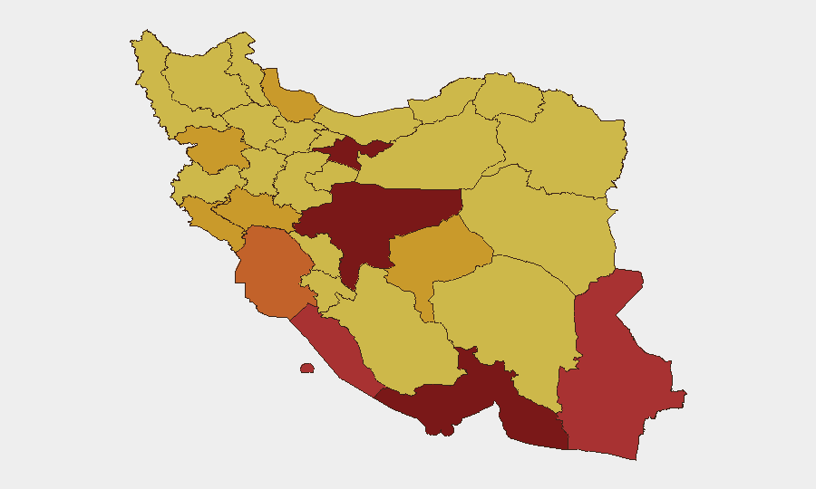
Tehran Province (risk 100) remains the political and security nerve center; strikes have not yet targeted the capital, but military arrests and internal dissent signal regime-stability stress. Southern coastal provinces—Hormozgan (86.4), Sistan and Baluchestan (78.4), Bushehr (77.2), and Khuzestan (75.1)—dominate current threat exposure due to concentration of IRGC naval, air-defense, and missile infrastructure now under direct U.S. targeting. Isfahan Province (87.8) ranks second, likely reflecting dual-use military-industrial assets and command facilities. Civilian populations in Ahvaz, Bandar Abbas, Chabahar, and Qeshm face immediate risks from strike continuation and secondary effects (hospital disruption, port closures, supply-chain breaks).
How GeoBit Would Assist
Security teams should deploy persistent Area-of-Interest monitoring on Tehran, Hormozgan, Khuzestan, and Sistan and Baluchestan provinces to generate real-time strike alerts and casualty/displacement signals. Live conflict mapping, battle-damage assessment via satellite imagery, and IRGC force-structure tracking enable rapid damage quantification and operational-readiness assessment. Maritime & aviation tracking combined with Strait of Hormuz route/network analysis allows alternative logistics planning as IRGC closure claims impact shipping; OSINT fusion and multi-language social/state-media monitoring provide ground-truth corroboration when official statements diverge.
7-Day Outlook
U.S. strike tempo is likely to continue or escalate given today's multi-front Iranian military posturing (Jordan, Qatar, Mexico threats) and IRGC Hormuz closure claims. Civilian infrastructure—hospitals, power plants, water systems—will remain at secondary-strike risk. Regional maritime traffic should expect further disruption and heightened boarding/interdiction risk; commercial insurance and routing contingencies are operationally critical.
Highest-Risk Areas — Ranked
| # | State / Region | Risk |
|---|---|---|
| 1 | Tehran Province | 100 |
| 2 | Isfahan Province | 87.8 |
| 3 | Hormozgan Province | 86.4 |
| 4 | Sistan and Baluchestan Province | 78.4 |
| 5 | Bushehr Province | 77.2 |
| 6 | Khuzestan Province | 75.1 |
| 7 | Yazd Province | 72.9 |
| 8 | Gilan Province | 71.7 |
| 9 | Kurdistan Province | 71.6 |
| 10 | Ilam Province | 71.2 |
| 11 | Lorestan Province | 71.2 |
| 12 | Fars Province | 70.8 |
Sources
Previous Daily Briefs
A new Iran brief is written every day — each with its own risk map and downloadable CSV. Here's the last week; use the calendar to go further back.
📅 Browse every day by calendar →
Highlighted days have a brief. Tap a day for that day's map & analysis, or “csv” for that day's dataset ($5).
Atlas — our AI intelligence desk — emails them this snapshot personally. Nothing else, no list.