Situation Summary
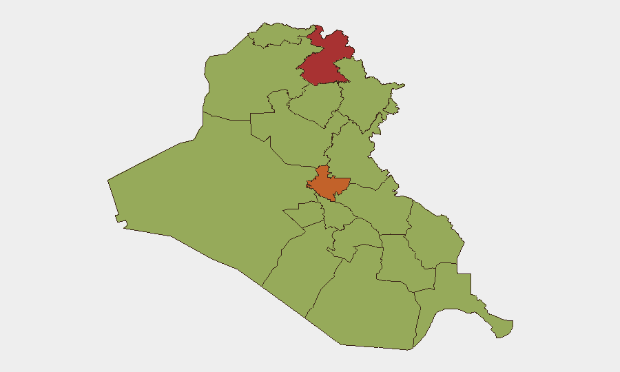
Iraq remains elevated on the global threat index (#19) with 225 tracked events, driven by cross-border drone and missile activity linked to broader US–Iran and Iran–Israel tensions. The security environment has escalated sharply over the past 72 hours, with multiple Western governments updating travel advisories and the US Embassy issuing complex-threat warnings citing potential airspace closures and flight disruptions. Current risk is concentrated in the Kurdistan Region (Erbil Governorate, 77.9 risk score) and Baghdad (74.2), where air-defense operations remain at elevated posture against further Iranian-linked aerial weapons activity.
Key Developments
- Baghdad, 25–26 July: US Embassy elevated security alert for all US citizens in Iraq, warning of complex threats and imminent risk of flight cancellations and airspace closures due to regional military escalation.
- Nationwide, 25–26 July: Multiple Western governments re-issued or updated travel advisories for Iraq, citing recent missile and drone strikes and warning that additional military activity could resume without warning, affecting civilian air traffic and overland routes.
- Erbil Governorate, 25–26 July: Ongoing drone interceptions and air-defense activity continues over Erbil airspace, with periodic disruptions to Erbil International Airport following explosive-laden drone attacks earlier in the week.
- Erbil–Sulaymaniyah corridor, 25–26 July: Air-defense operations and aerial weapons activity remain elevated across northern Iraq as Iraqi and coalition forces maintain heightened posture against Iranian-linked drone and missile threats.
- Kirkuk Air Base (K-1), 25–26 July: Recent fire incident remains under assessment by Iraqi authorities; damage and cause still being evaluated with no confirmed casualty figures released.
- Iraq–Iran border, 25–26 July: Intensified cross-border artillery, drone, and UAV activity linked to US–Iran and Iran–Israel confrontation; Iraqi armed forces conducting internal security operations in multiple governorates to manage spillover risk.
Highest-Risk Areas
Erbil Governorate (77.9) and Baghdad Governorate (74.2) drive the majority of current threat activity, both experiencing sustained air-defense operations and aerial weapons strikes. Erbil's elevated ranking reflects its position as a major coalition hub and repeated Iranian-linked drone targeting; Baghdad concentrates diplomatic, government, and critical-infrastructure targets vulnerable to similar attack vectors. The remaining high-risk governorates (Sulaymaniyah, 54.3; Al-Anbar, 48.3) follow at secondary-tier threat levels, primarily reflecting conventional military force presence and border security operations rather than active incident activity in the past 48 hours.
How GeoBit Would Assist
Security teams would deploy AOI (Area-of-Interest) Monitoring & Early Warning on Erbil and Baghdad airbases, airports, and diplomatic compounds to detect imminent air-defense activation or strike patterns before public announcement. Conflict & Military battle mapping and force-structure tracking would identify real-time Iraqi, coalition, and Iranian-linked unit positions and air-defense readiness to inform movement decisions. Aviation tracking linked to Intel Sweep and multi-source OSINT fusion would flag airspace closures, flight cancellations, and routing constraints in near-real-time, enabling duty-of-care teams to adjust personnel movements and supply chains before disruption cascades.
7-Day Outlook
Regional tensions remain acute; no de-escalation signals are evident in public statements or military posture. Further drone or missile activity targeting Iraq is assessed as probable, with highest likelihood concentrated on coalition and US-linked facilities in Erbil and Baghdad. Airspace and travel disruptions should be anticipated through early August unless a clear de-escalation signal emerges from US–Iran diplomatic channels.
Highest-Risk Areas — Ranked
| # | State / Region | Risk |
|---|---|---|
| 1 | Erbil Governorate | 77.9 |
| 2 | Baghdad Governorate | 74.2 |
| 3 | Sulaymaniyah Governorate | 54.3 |
| 4 | Al-Anbar Governorate | 48.3 |
| 5 | Halabja Governorate | 48.3 |
| 6 | Babil Governorate | 47.9 |
| 7 | Wasit Governorate | 47.9 |
| 8 | Al-Qadisiyah Governorate | 47.9 |
| 9 | Dhi Qar Governorate | 47.9 |
| 10 | Al-Muthanna Governorate | 47.9 |
| 11 | Maysan Governorate | 47.9 |
| 12 | Al-Basra Governorate | 47.9 |
Sources
Previous Daily Briefs
A new Iraq brief is written every day — each with its own risk map and downloadable CSV. Here's the last week; use the calendar to go further back.
📅 Browse every day by calendar →
Highlighted days have a brief. Tap a day for that day's map & analysis, or “csv” for that day's dataset ($5).
Atlas — our AI intelligence desk — emails them this snapshot personally. Nothing else, no list.