Situation Summary
Mexico remains in the grip of elevated organized-crime violence and sustained federal security operations, six months after the late-February 2026 nationwide cartel attacks and killing of CJNG leader "El Mencho." While large-scale violence has subsided from February peaks, the security posture remains elevated across western and central states, with persistent highway disruptions, checkpoints, and operational constraints affecting travel, logistics, and port access. The current threat environment is characterized by fragmented but ongoing cartel activity, federated law-enforcement presence, and infrastructure strain rather than acute crisis, but instability in key economic corridors—particularly Jalisco, Colima, and Tamaulipas—continues to pose operational risk to corporate assets and personnel.
Key Developments
- Guadalajara–Zapotlanejo toll corridors, Jalisco (July 31–Aug 1): Authorities report 83% clearance of cartel-related road blockages; seven closures remain due to burned vehicles on the Guadalajara–Zapotlanejo and Zapotlanejo–Lagos de Moreno routes, with completion expected within 36 hours. Risk of continued delays and rerouting for cargo operations remains elevated.
- Jalisco statewide security posture (July 31–Aug 1 update): State Security Committee remains in permanent session with 2,500 federal troops and 150 Navy personnel deployed; 24/7 highway patrols and checkpoints continue on key routes including approaches to Guadalajara and Manzanillo. Expect ongoing inspection delays and sporadic closures for intercity freight and passenger traffic.
- Manzanillo Port, Colima (July 31–Aug 1): Port remains open under ISPS Level I but with reinforced Navy security and tightened access controls. Operations are functional but subject to longer gate times, stricter cargo/personnel checks, and possible procedural changes.
- Monterrey metropolitan area mobility, Nuevo León (late July): U.S. consulate staff remain directed to stay within the metropolitan area; continued caution on road travel toward Tamaulipas, Coahuila, and border corridors reflects ongoing nationwide security operations.
- Multi-state toll-road curtailments (last 48 hours): Residual closures and intermittent operations persist on toll roads in Puebla, Guerrero, Tamaulipas, Nayarit, San Luis Potosí, Baja California (Tijuana), Querétaro, Veracruz, and Sinaloa (Mazatlán), increasing unpredictability for inter-state road movement.
- Puerto Vallarta airport and ground transport (last 24–48 hours): Ongoing flight crew availability disruptions and uneven taxi/ride-share service resumption continue to affect passenger and logistics operations; other major Mexican airports operate normally.
- Western Mexico federal deployments (last 24–48 hours): Heightened checkpoints and large military/police presence persist across Jalisco, Colima, Michoacán, and Guanajuato as part of sustained federal operations; no new acute violence but continued operational friction.
Highest-Risk Areas
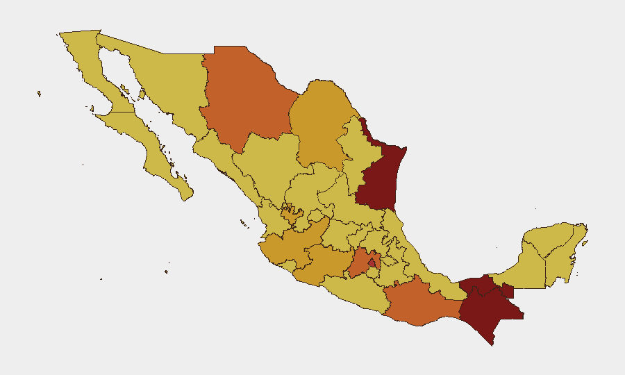
Tabasco (97.1), Chiapas (81.5), and Tamaulipas (81.3) pose the greatest composite threat, driven by organized-crime territorial disputes, trafficking infrastructure, and limited institutional control. Mexico City (79.4) and Chihuahua (75.9) remain elevated due to cartel presence and urban violence. The western corridor—Jalisco (71.4), Colima, and Michoacán (71.4)—faces sustained federal operations and residual violence linked to the February security crisis; this region is critical for logistics, ports, and tourism. Corporate teams should prioritize real-time monitoring of highway status and checkpoint operations in these states.
How GeoBit Would Assist
GeoBit's AOI Monitoring & Early Warning capability with persistent watch and alerting on Jalisco, Tamaulipas, and Colima corridors would provide advance notice of new blockades, checkpoint intensification, or security operations affecting supply chains. Routing & Network Analysis would identify operational alternative routes around persistent toll-road closures in Puebla, Veracruz, and Sinaloa. Multi-language OSINT (X, Telegram, local media) fusion and temporal analysis would separate current operational updates from historical background, ensuring accurate near-term threat assessment for travel and asset-movement decisions.
7-Day Outlook
Toll-road clearance operations are expected to complete within 36 hours, easing but not eliminating logistics friction on major Jalisco corridors. Federal security posture will remain elevated; no major escalation is anticipated, but checkpoints and delays should be factored into planning. Puerto Vallarta air operations may continue to experience sporadic disruptions, whereas other major airports should remain operationally stable.
Highest-Risk Areas — Ranked
| # | State / Region | Risk |
|---|---|---|
| 1 | Tabasco | 97.1 |
| 2 | Chiapas | 81.5 |
| 3 | Tamaulipas | 81.3 |
| 4 | Mexico City | 79.4 |
| 5 | Chihuahua | 75.9 |
| 6 | Oaxaca | 74.5 |
| 7 | State of Mexico | 74.2 |
| 8 | Coahuila | 72.8 |
| 9 | Jalisco | 71.4 |
| 10 | Michoacán | 71.4 |
| 11 | Guanajuato | 70.4 |
| 12 | Morelos | 70.2 |
Sources
Previous Daily Briefs
A new Mexico brief is written every day — each with its own risk map and downloadable CSV. Here's the last week; use the calendar to go further back.
📅 Browse every day by calendar →
Highlighted days have a brief. Tap a day for that day's map & analysis, or “csv” for that day's dataset ($5).
Atlas — our AI intelligence desk — emails them this snapshot personally. Nothing else, no list.