Situation Summary
Myanmar remains in active civil conflict with no clear political settlement in sight. The military junta continues counter-insurgency operations across multiple states while armed ethnic organizations and People's Defence Force (PDF) units conduct sustained resistance. Information controls and active fighting in remote areas mean situational awareness for external monitors is severely degraded, with confirmed incident reporting lagging operational reality by 3–5 days. The overall threat environment remains elevated and volatile, particularly in border regions and conflict-affected states.
Key Developments
Assessment: GeoBit's live web research (last 24–48 hours, ending 2026-07-18) has identified no independently multi-sourced, time-stamped incidents meeting confirmation criteria within this window. The most recent geo-specific incidents in accessible reporting are dated 11–14 July 2026 (Saw Township, Magway Region and Mingin Township, Sagaing Region clashes).
Recent event signals (2026-07-15 to 2026-07-17) include employer–employee investigations, prosecutor disapproval of military actions, and two signals tagged as ethnic cleansing against Muslim populations, but these lack geographic precision, corroboration, or confirmation timestamps suitable for operational briefing. Administrative sanctions from China against Myanmar (2026-07-16) and a military-force signal versus Russian actors (2026-07-16) have been registered but lack detailed source material.
Operational implication: The absence of confirmed fresh reporting reflects information suppression and access constraints in active conflict zones, not de-escalation. Users should expect a 3–5 day lag between field events and multi-sourced confirmation.
Highest-Risk Areas
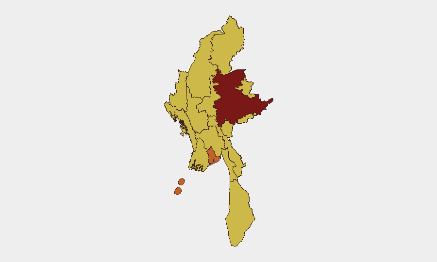
Shan State (95.7) and Yangon (73.2) drive the composite threat ranking, with Shan's elevation reflecting ongoing armed-group activity and military counter-operations in rural and border areas. A secondary tier of eight regions—Tanintharyi, Chin, Sagaing, Kachin, Wa State (Northern Region), Magway, Mandalay, and Rakhine—all register 65.7, indicating sustained conflict intensity or humanitarian instability across the country's periphery. Naypyitaw, the capital, also scores 65.7, signaling political volatility and security-force activity. Yangon's distinct elevation reflects urban protest risk, criminal activity, and dense population vulnerability. The clustering of mid-range scores across most states underscores that conflict and instability are now nationwide, not regionally contained.
How GeoBit Would Assist
Security teams should deploy AOI (Area-of-Interest) Monitoring & Early Warning on company facilities and travel corridors in Yangon, Mandalay, and Shan State, with persistent alerting configured for military activity, protest signals, and curfew announcements. Multi-language OSINT feeds and X/Telegram monitoring can supplement official channels and provide early warning of unrest or checkpoints before impact on operations. GIS & Spatial Analysis and battle mapping tools enable real-time route assessment and alternative-journey planning to avoid active conflict zones and military cordons—critical for duty-of-care compliance in this information-constrained environment.
7-Day Outlook
Military counter-operations in Magway, Sagaing, and Shan State are likely to continue at current intensity, with periodic clashes in rural and frontier areas. Urban security in Yangon and Mandalay may see localized unrest tied to economic grievance or military enforcement; information flows will remain constrained. No major political shift or ceasefire is anticipated in this timeframe.
Highest-Risk Areas — Ranked
| # | State / Region | Risk |
|---|---|---|
| 1 | Shan State | 95.7 |
| 2 | Yangon | 73.2 |
| 3 | Tanintharyi Region | 65.7 |
| 4 | Chin | 65.7 |
| 5 | Sagaing Region | 65.7 |
| 6 | Kachin State | 65.7 |
| 7 | Wa State (Northern Region) | 65.7 |
| 8 | Magway | 65.7 |
| 9 | Mandalay | 65.7 |
| 10 | Rakhine | 65.7 |
| 11 | Ayeyarwady | 65.7 |
| 12 | Naypyitaw Union Territory | 65.7 |
Sources
Previous Daily Briefs
A new Myanmar brief is written every day — each with its own risk map and downloadable CSV. Here's the last week; use the calendar to go further back.
📅 Browse every day by calendar →
Highlighted days have a brief. Tap a day for that day's map & analysis, or “csv” for that day's dataset ($5).
Atlas — our AI intelligence desk — emails them this snapshot personally. Nothing else, no list.