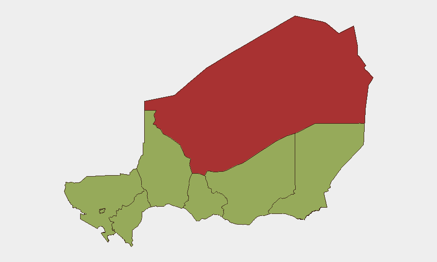
Situation Summary
Niger's security environment remains fractured and high-risk, with Agadez Region substantially outpacing all other zones in threat intensity (composite risk 79.5 vs. 49.5 nationwide average for secondary regions). No new discrete security incidents—attacks, protests, kidnappings, or infrastructure disruptions—were corroborated in the last 24–48 hours; however, ongoing military sweep operations in Tillabéri Region (active as of July 23–24 following a July 17 ambush) and persistent structural risks (terrorist kidnapping, violent crime targeting foreign nationals, attacks on government facilities) sustain elevated baseline threat across the country. The overall composite threat score of 71 reflects chronic instability rather than acute escalation.
Key Developments
- Nationwide (July 24–25, 2026): Public statement issued by the Governor; no discrete new incidents recorded in open-source reporting or regional media within the 24–48-hour window.
- Niger–Libya border (July 25, 2026): Occupy Territory events reported involving Niger state forces vs. Libya and Niamey municipal authorities vs. Libya; nature and scale require further corroboration.
- Niger Delta (July 25, 2026): Conventional Military Force event reported involving Niger Delta actors vs. Secret Police; details remain sparse in open-source channels.
- Tillabéri Region, Téra–Bankilaré–Doungouro corridor (ongoing as of July 23–24, 2026): Military search-and-sweep operations continue following the July 17 ambush that resulted in 16 soldier casualties; forces remain deployed to locate remaining militants and secure the road axis. This is a continuation of earlier incident response, not a new attack.
- Structural risk persistence (July 23–24, 2026): Daily threat assessments confirm no newly recorded discrete incidents but flag sustained risk of terrorist kidnapping, violent crime targeting foreigners, and potential attacks on government and urban targets nationwide.
Highest-Risk Areas
Agadez Region dominates the sub-national risk profile (79.5), more than 60% above secondary zones, driven by sustained militant activity, weak state presence, and historical trafficking corridors. Zinder, Diffa, and Tillabéri Regions, along with Niamey, Tahoua, Dosso, and Maradi, cluster at 49.5, indicating a broad secondary belt of concern where kidnapping, criminal violence, and militant operations pose recurring threats. Niamey's inclusion in that secondary tier reflects urban crime, protest potential, and attacks on government facilities; Diffa and Tillabéri, abutting Mali and Burkina Faso, face cross-border militant spillover. The sharp differential between Agadez and all other zones suggests that security posture and resource allocation should be heavily weighted toward that region.
How GeoBit Would Assist
Security teams with personnel or assets in Niger would leverage AOI Monitoring & Early Warning to track Agadez, Diffa, and Tillabéri in real time and receive alerts on emerging incidents before public disclosure. Conflict & Military mapping and Force Structure analysis would track military sweep operations and militant repositioning, informing travel routing and site security. Routing & Network Analysis would enable alternative journey planning for staff and supply movements, circumventing high-risk corridors (e.g., Tillabéri road axis) and reducing kidnapping or ambush exposure.
7-Day Outlook
No major escalation is signaled in the near term, but the absence of reported discrete incidents in the last 48 hours should not be mistaken for reduced threat; rather, baseline risk remains high and conditions are fluid. Military operations in Tillabéri and border tensions with Libya warrant close monitoring. Organizations should maintain heightened situational awareness and pre-positioned contingency protocols, particularly in Agadez and Diffa Regions.
Highest-Risk Areas — Ranked
| # | State / Region | Risk |
|---|---|---|
| 1 | Agadez Region | 79.5 |
| 2 | Zinder Region | 49.5 |
| 3 | Diffa Region | 49.5 |
| 4 | Tillabéri Region | 49.5 |
| 5 | Niamey | 49.5 |
| 6 | Tahoua Region | 49.5 |
| 7 | Dosso Region | 49.5 |
| 8 | Maradi Region | 49.5 |
Sources
Previous Daily Briefs
A new Niger brief is written every day — each with its own risk map and downloadable CSV. Here's the last week; use the calendar to go further back.
📅 Browse every day by calendar →
Highlighted days have a brief. Tap a day for that day's map & analysis, or “csv” for that day's dataset ($5).
Atlas — our AI intelligence desk — emails them this snapshot personally. Nothing else, no list.