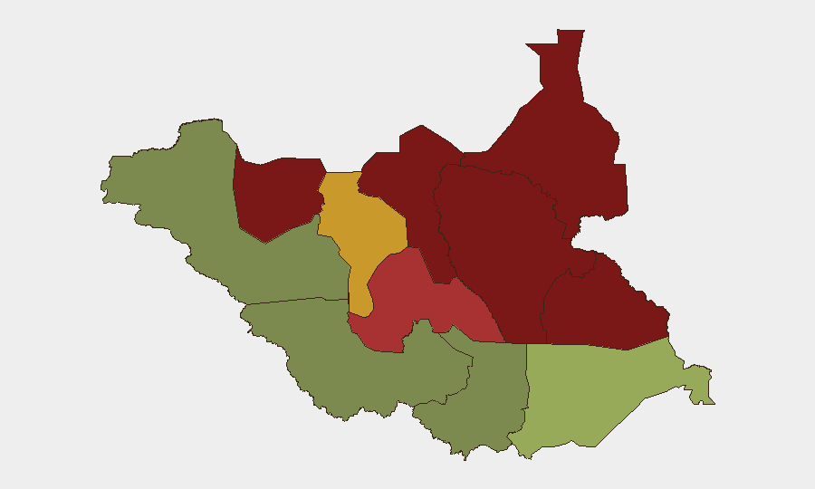
Situation Summary
South Sudan remains in active armed conflict with coordinated clashes resuming across multiple northern and central states (Unity, Jonglei, Upper Nile, Western and Central Equatoria) between 20–22 August, driven by underlying SSPDF–SPLM/A-IO tensions and intercommunal violence. A critical security incident occurred on 24 August when UNMISS peacekeepers were ambushed near Pajut in Jonglei State, resulting in 2 UN deaths and 7 injured, prompting diplomatic condemnation and renewed warnings of heightened risk along major transport corridors. The national security environment is assessed by AU/UN sources as "increasingly volatile," with ongoing ceasefire violations, persistent displacement (35,000+ newly displaced in Kajo-Keji, Central Equatoria), and continued targeting of aid workers (36 killed in 2026 to date). Risk trajectory is deteriorating.
Key Developments
- Pajut, Duk County, Jonglei State – 24 August 2026 (reported 24–26 Aug). UNMISS patrol en route from Bor to Pajut ambushed by unidentified armed individuals; 2 UN peacekeepers killed, 7 personnel injured (3 peacekeepers, 2 South Sudan National Police officers, 2 UN civilian staff). Quick Reaction Force deployed for medical evacuation and area security.
- Bor–Pajut corridor, Jonglei State – 24–26 August 2026. U.S. Embassy, EU Delegation, and multiple European missions issued public warnings identifying the corridor as high-risk for convoys and humanitarian movements; diplomatic statements tied the ambush to wider security deterioration in the region.
- Liwolo area, Kajo-Keji County, Central Equatoria – through 25 August 2026. Over 35,000 displaced persons sheltering in Liwolo following recent border clashes near South Sudan–Uganda frontier; UNMISS access constrained by washed-out roads, indicating ongoing cross-border instability and humanitarian pressure.
- Upper Nile, Jonglei, Unity States – 20–24 August 2026 (ongoing). Coordinated armed clashes resumed across all three states as part of multi-state escalation documented by UN Commission; assessments dated 20–24 August and carried into 25–26 August briefings confirm active fighting and ceasefire violations continuing into the current reporting period.
- Western and Central Equatoria – 20–22 August 2026 (ongoing). Resumption of armed clashes with documented civilian deaths; part of same multi-state escalation affecting northern and central regions.
- National humanitarian operations – 25–26 August 2026 (current). AU/UN briefings confirm continued attacks on aid workers, administrative impediments to relief, and ongoing cholera outbreak; 36 humanitarian workers killed in 2026 so far, signaling sustained targeting of aid operations and ongoing health emergency.
Highest-Risk Areas
Unity (risk 95), Jonglei (93), and Upper Nile (88) drive the composite threat profile and are centers of active armed conflict between SSPDF and opposition forces (SPLM/A-IO and allied groups). Jonglei in particular presents immediate acute risk following the 24 August UNMISS ambush and is the focal point for diplomat warnings on transport corridor security. Northern Bahr el Ghazal (82) and Greater Pibor Administrative Area (87) are secondary conflict zones with intercommunal and cattle-related violence. Central Equatoria (35) and Western Equatoria (38) rank lower but are experiencing renewed clashes and displacement; Western Bahr el Ghazal (28) and Central Equatoria remain relatively more stable, though cross-border dynamics in the latter are now active.
How GeoBit Would Assist
AOI Monitoring & Early Warning with persistent alerts on Jonglei, Unity, and Upper Nile would provide real-time ingestion of ambush, battle, and displacement signals ahead of diplomatic alerts. Routing & Network Analysis applied to the Bor–Pajut and border corridors would identify safer movement windows and alternative routes for personnel or supply convoys. Conflict & Military force-structure tracking and Network & Actor Analysis would clarify SSPDF/SPLM/A-IO deployments and armed-group positions to support duty-of-care risk assessment for field operations.
7-Day Outlook
Armed clashes and intercommunal violence are likely to persist across Unity, Jonglei, and Upper Nile through early September given unresolved underlying political and resource tensions. The ambush on UNMISS and diplomatic warnings signal that major transport corridors remain targeted and movement risk is elevated. Displacement and humanitarian-worker targeting are expected to continue; health emergencies (cholera) will compound operational complexity for field teams.
Highest-Risk Areas — Ranked
| # | State / Region | Risk |
|---|---|---|
| 1 | Unity | 95 |
| 2 | Jonglei | 93 |
| 3 | Upper Nile | 88 |
| 4 | Greater Pibor Administrative Area | 87 |
| 5 | Northern Bahr el Ghazal | 82 |
| 6 | Lakes | 78 |
| 7 | Warrap | 72 |
| 8 | Ruweng Administrative Area | 68 |
| 9 | Eastern Equatoria | 52 |
| 10 | Western Equatoria | 38 |
| 11 | Central Equatoria | 35 |
| 12 | Western Bahr el Ghazal State | 28 |
Sources
Previous Daily Briefs
A new South Sudan brief is written every day — each with its own risk map and downloadable CSV. Here's the last week; use the calendar to go further back.
- August 24, 2026
- August 22, 2026
- August 20, 2026
- August 18, 2026
- August 16, 2026
- August 14, 2026
- August 12, 2026
📅 Browse every day by calendar →
Highlighted days have a brief. Tap a day for that day's map & analysis, or “csv” for that day's dataset ($5).
Atlas — our AI intelligence desk — emails them this snapshot personally. Nothing else, no list.