Situation Summary
Sudan remains the third-highest global threat environment (composite score 97), driven by active civil war between the Sudanese Armed Forces (SAF) and Rapid Support Forces (RSF) now in its second year. Over the past 48 hours, both sides have conducted major conventional military operations along the strategically critical Omdurman–El Obeid corridor in North Kordofan State, with SAF claiming territorial gains and RSF responding with drone strikes. Simultaneously, urban crime and gang violence have sharply escalated in Khartoum State and White Nile State, signaling deterioration in civilian security beyond front-line combat zones.
Key Developments
- El Obeid, North Kordofan – 27 July 2026 (early morning). RSF launched eight suicide drone attacks against SAF Fifth Infantry Division headquarters; SAF reported significant explosions and damage but no confirmed casualties. The strikes were described as retaliation for SAF control claims over the Al Sadarat highway.
- Al Sadarat highway corridor, North Kordofan – 26 July 2026 (Sunday). SAF announced full control restoration of the strategic supply route between Omdurman and El Obeid following two days of heavy fighting with RSF, enabling movement of troops, fuel, and supplies intended to break the RSF siege of El Obeid.
- Bara, Um Sayala, Um Garfa, and Jabra al-Sheikh, North Kordofan – 25–26 July 2026. SAF and allied joint-force units reported recapture of at least five locations from RSF control, with claims of heavy RSF losses; independent reporting confirms major fighting but notes contested control over some segments of the Omdurman–El Obeid export road.
- Omdurman–El Obeid export route – 25–27 July 2026. SAF statements claimed retaking of Um Qurfa and Jarigakh positions; local sources cited in independent reporting disputed full route reopening, noting ongoing clashes despite SAF claims of tightened grip.
- Southern Omdurman and peripheral Khartoum State districts – late July 2026 (recent weeks). Security authorities reported rising armed gang activity including home invasions and armed robberies in areas such as Al-Salha, with at least two deaths and dozens of burglaries documented.
- Rabak, White Nile State – recent nights, late July 2026. Escalating nighttime gang violence documented, including murder of a civilian during a home robbery, driving heightened community fear and reflecting criminal insecurity expansion beyond war zones.
- Port Sudan, Red Sea State – ongoing, late July 2026. Extreme heatwave conditions have disrupted daily life for nearly one million residents, with widespread health warnings of heatstroke risk affecting children and outdoor workers, compounding infrastructure and public-health strain.
Highest-Risk Areas
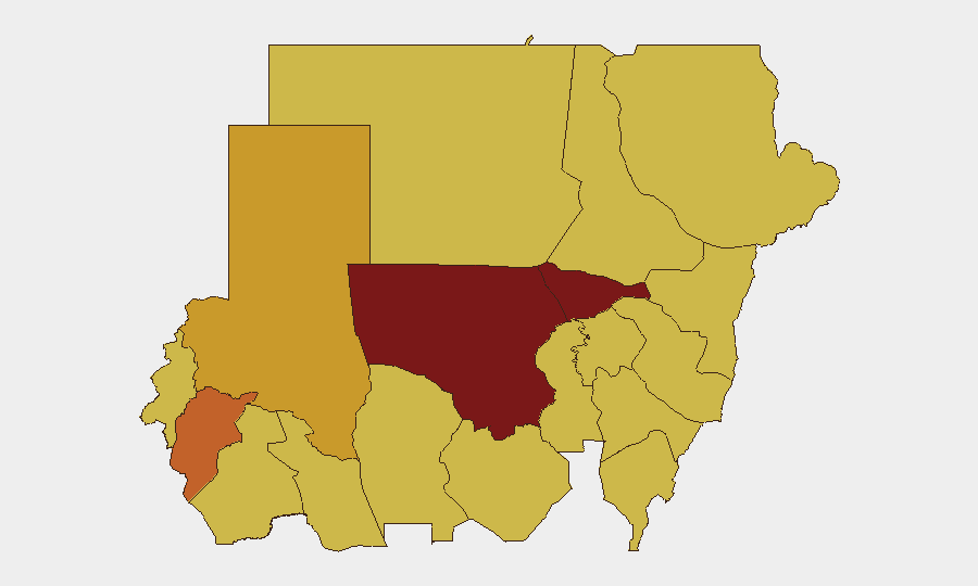
North Kordofan State (score 98) dominates the risk ranking, driven by continuous SAF–RSF conventional warfare along the Omdurman–El Obeid corridor, drone strikes, and territorial contestation over critical supply lines. Al Khartum (81.5) reflects both active urban conflict and the documented surge in armed gang violence and home invasions in recent weeks. Central and North Darfur, White Nile, and the eastern states (Blue Nile, River Nile, Red Sea) all register elevated risk (68–74.4), reflecting distributed conflict activity, criminal insecurity, and humanitarian strain.
How GeoBit Would Assist
Security teams with personnel or assets in Sudan should employ Intel Sweep and multi-language OSINT feeds for real-time event tracking, battle mapping and force-structure analysis to assess SAF and RSF territorial control claims, and AOI Monitoring with alerting on North Kordofan, Khartoum State, and White Nile to detect escalation in military operations or crime patterns. Routing & Network Analysis can identify safe and alternative transit corridors as supply-route control shifts. Satellite & Imagery analysis can corroborate ground claims of territorial change and infrastructure damage.
7-Day Outlook
Expect continued SAF–RSF contestation along the Omdurman–El Obeid corridor and potential follow-on drone or artillery exchanges. Urban crime in Khartoum and secondary cities will likely remain elevated amid conflict-driven state collapse. Any sudden SAF or RSF tactical reversal could trigger rapid corridor control shifts and affect movement of personnel and goods.
Highest-Risk Areas — Ranked
| # | State / Region | Risk |
|---|---|---|
| 1 | North Kordofan State | 98 |
| 2 | Al Khartum | 81.5 |
| 3 | Central Darfur State | 74.4 |
| 4 | North Darfur State | 71.7 |
| 5 | White Nile | 68.2 |
| 6 | Blue Nile | 68 |
| 7 | River Nile State | 68 |
| 8 | Aj Jazira | 68 |
| 9 | Red Sea State | 68 |
| 10 | Al Qadarif State | 68 |
| 11 | Kassala State | 68 |
| 12 | Sennar State | 68 |
Sources
Previous Daily Briefs
A new Sudan brief is written every day — each with its own risk map and downloadable CSV. Here's the last week; use the calendar to go further back.
📅 Browse every day by calendar →
Highlighted days have a brief. Tap a day for that day's map & analysis, or “csv” for that day's dataset ($5).
Atlas — our AI intelligence desk — emails them this snapshot personally. Nothing else, no list.