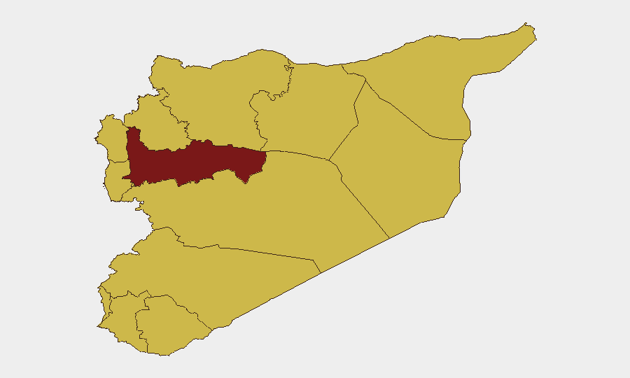
Situation Summary
Syria remains the sixth-highest-threat country globally, driven by active warfare, cross-border military operations, and diffuse criminal violence. The past 24–48 hours have seen a sharp spike in Israeli ground incursions into southern provinces, coupled with at least nine fatalities from shootings and armed clashes across multiple governorates nationwide. Damascus and Hama remain the highest-risk zones, but violence is increasingly dispersed across residential areas, border regions, and provincial towns, complicating threat avoidance for resident and transiting personnel.
Key Developments
- Israeli ground incursions – Daraa & Quneitra provinces (past 24–48 hours). SOHR reports seven Israeli ground incursions and two attacks in the Yarmouk Basin and al-Hamidiyah area, including temporary checkpoints, drone and helicopter overflights, and shelling on provincial outskirts. Risk is elevated for cross-border movement and rural southern Syria operations.
- Lethal shooting spree – nine fatalities across six governorates (past 24 hours). Kurdistan Press cites Hawar News and local sources reporting at least nine deaths from shootings, family-conflict escalations, and armed clashes in Hama (Al-Kharsana), Homs (Al-Sultaniya, al-Ureida), Daraa (Sheikh Saad), Aleppo (Manbij), Damascus outskirts (Sahnaya, al-Tal), and Hasakah. Incidents include execution-style killings, family disputes, and targeted attacks on security-force personnel.
- Landmine fatality – al-Damair, Rif Dimashq (past 24 hours). A civilian death from unexploded ordnance near Damascus underscores persistent hazard in countryside areas and underutilized routes.
- Targeted killing of 60th Division soldier – Hasakah countryside (past 24 hours). Unknown gunmen killed a soldier under Syrian Interim Government control in the northeast, indicating sustained threat to non-regime security forces in SIG-held territory.
- Interpersonal armed escalations – Homs city & border zone, Manbij (past 24 hours). Multiple family and neighborhood disputes devolved into armed shootouts in urban and semi-rural settings, reflecting low thresholds for lethal force in civilian dispute resolution.
- Nationwide pattern of diffuse violence. Unlike traditional front-line concentration, current fatalities span residential districts (Sahnaya, al-Tal, Homs neighborhoods), provincial towns (Manbij, Hama), and border areas (al-Ureida), indicating security risk is no longer geographically confined and affects routine civilian and business movement.
Highest-Risk Areas
Damascus Governorate (risk 97) and Hama (94.3) dominate the ranking and reflect ongoing military operations, urban crime, and regime-opposition activity. However, the recent 24-hour incident cluster reveals significant risk outside traditional conflict zones: Daraa and Quneitra have spiked due to Israeli incursions, while Homs, Aleppo, and countryside zones are now hotspots for armed criminal violence. The flattening of risk scores across Deir ez-Zor, Idleb, As-Suweida, Lattakia, Tartus, and Al-Quneitra (all 67+) suggests that secondary and peripheral areas now pose comparable hazard to residents and personnel. Personnel security teams should assume that routine movement through any governorate carries exposure to crossfire, checkpoints, or crime-related shootings.
How GeoBit Would Assist
Security teams would deploy AOI Monitoring & Early Warning on personnel locations and critical infrastructure to receive real-time alerts on shootings, military activity, and cross-border incursions. Routing & Network Analysis capabilities enable identification of alternative movement corridors avoiding documented violence clusters and checkpoint concentrations. OSINT Fusion & Corroboration (X, Telegram, local news aggregation, multi-language sentiment analysis) provides 24-hour situational updates on incident patterns and threat-actor movement, supporting duty-of-care incident response and evacuation planning.
7-Day Outlook
Israeli ground activity in the south is likely to persist if broader regional tensions remain unresolved. Expect continued clustering of armed clashes and criminal shootings in urban centers and countryside—neither front-line nor rear-area designation is now reliable for safety planning. Any escalation in Iranian, U.S., or Israeli operations near Syria will rapidly degrade overall security conditions nationwide.
Highest-Risk Areas — Ranked
| # | State / Region | Risk |
|---|---|---|
| 1 | Damascus Governorate | 97 |
| 2 | Hama Governorate | 94.3 |
| 3 | Deir ez-Zor Governorate | 67.7 |
| 4 | Idleb Governorate | 67.2 |
| 5 | As-Suweida Governorate | 67.2 |
| 6 | Lattakia Governorate | 67 |
| 7 | Tartus Governorate | 67 |
| 8 | UNDOF | 67 |
| 9 | Al-Quneitra Governorate | 67 |
| 10 | Dar'a Governorate | 67 |
| 11 | Aleppo Governorate | 67 |
| 12 | Ar-Raqqa Governorate | 67 |
Sources
Previous Daily Briefs
A new Syria brief is written every day — each with its own risk map and downloadable CSV. Here's the last week; use the calendar to go further back.
📅 Browse every day by calendar →
Highlighted days have a brief. Tap a day for that day's map & analysis, or “csv” for that day's dataset ($5).
Atlas — our AI intelligence desk — emails them this snapshot personally. Nothing else, no list.