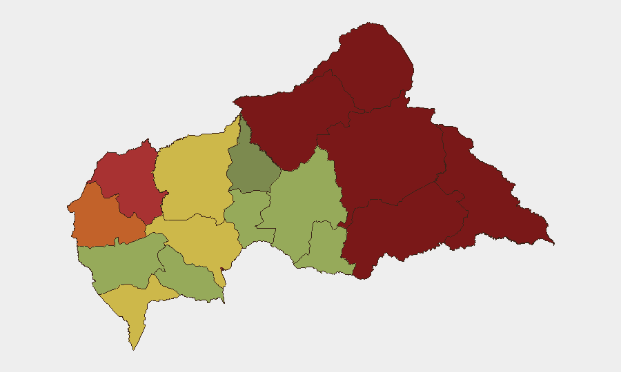
Situation Summary
Central African Republic remains under structural chronic insecurity, ranking #31 globally (composite threat score 70) with no discrete security events reported in the last 24–48 hours. The country faces persistent armed-group activity, inter-communal violence, and political tension, particularly across its northern and eastern prefectures. The security environment remains volatile but without reportable incident-level developments in the immediate 24–48 hour window; most recent documented activity dates to mid-July 2026 or earlier.
Key Developments
No verifiable security incidents meeting multi-source confirmation standards have been reported in Central African Republic for 25–27 July 2026. Available open-source feeds, social-media monitoring, and local media show a data gap consistent with broader regional reporting constraints in the Sahel. Recent credible incident reporting in CAR (inter-communal violence in Boali, security proposals by UFDO for checkpoints around Bangui, detention of activist Aba Oumar near KM5 district) dates to 23 July or earlier and does not meet the 24–48 hour criterion. Persistent structural risks—armed-group presence, cross-border instability, and political sensitivity—continue but lack new time-stamped events in the requested window. Duty-of-care teams should rely on the 5–7 day outlook and standing sub-national risk rankings (below) rather than expect discrete incident updates in very short reporting windows for CAR.
Highest-Risk Areas
Vakaga (risk 95), Bamingui-Bangoran (92), and Haute-Kotto (88) in the northeast and east remain the highest-risk prefectures, driven by cross-border armed-group activity, minerals trafficking, and limited state presence. Haut-Mbomou (85) and Mbomou (82) in the southeast face similar pressures, exacerbated by ungoverned space near the DRC and South Sudan borders. Bangui itself (risk 78) remains tense due to political dynamics, criminal activity, and periodic communal friction; Ouham-Pendé (79) in the northwest also shows elevated risk. The pattern reflects CAR's vulnerability along its periphery, particularly the north and east, where armed groups exploit state weakness and cross-border terrain. Mid-west and central regions (Ouham, Ombella-M'Poko, Kémo) show comparatively lower but still significant risk.
How GeoBit Would Assist
Security teams operating in or monitoring CAR should deploy persistent AOI Monitoring & Early Warning on Vakaga, Bangui, and other high-risk prefectures to capture emerging incidents and armed-group movement as soon as corroborable reporting emerges. OSINT Fusion & Corroboration (X/Twitter, Telegram, local media, and multi-language search) enables real-time signal detection across fragmented local and diaspora sources, critical in environments with sparse formal reporting. Risk & Threat Assessment combined with GIS & Spatial Analysis allows duty-of-care teams to map personnel and asset exposure against sub-national risk layers, inform travel restrictions, and plan alternative routing and contingencies via Routing & Network Analysis tools.
7-Day Outlook
The security environment is expected to remain tense but without major escalation in the immediate near term. Political sensitivities and armed-group activity in the north and east will persist; inter-communal friction in central areas (Boali, Nana-Mambéré) may resurface. Organizations should maintain current security postures, monitor high-risk prefectures for emerging incidents, and avoid non-essential movement in Vakaga, Bamingui-Bangoran, and Haute-Kotto.
Highest-Risk Areas — Ranked
| # | State / Region | Risk |
|---|---|---|
| 1 | Vakaga | 95 |
| 2 | Bamingui-Bangoran | 92 |
| 3 | Haute-Kotto | 88 |
| 4 | Haut-Mbomou | 85 |
| 5 | Mbomou | 82 |
| 6 | Ouham-Pendé | 79 |
| 7 | Bangui | 78 |
| 8 | Nana-Mambéré | 75 |
| 9 | Sangha-Mbaéré | 68 |
| 10 | Ouham | 65 |
| 11 | Ombella-M'Poko | 62 |
| 12 | Kémo | 58 |
Sources
Previous Daily Briefs
A new Central African Republic brief is written every day — each with its own risk map and downloadable CSV. Here's the last week; use the calendar to go further back.
📅 Browse every day by calendar →
Highlighted days have a brief. Tap a day for that day's map & analysis, or “csv” for that day's dataset ($5).
Atlas — our AI intelligence desk — emails them this snapshot personally. Nothing else, no list.