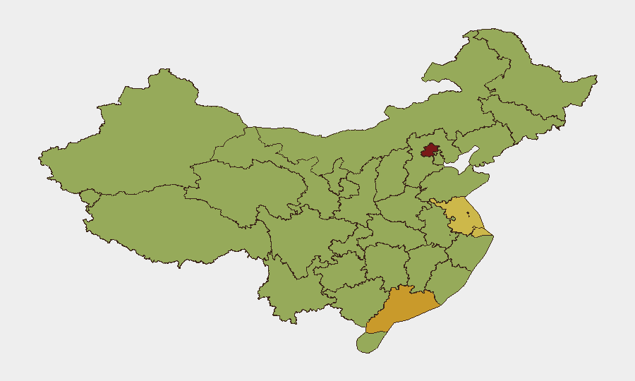
Situation Summary
China's overall security environment remains stable with no significant civil unrest, political instability, or military escalation events reported in the last 24–48 hours. Operational risk is currently dominated by weather impacts from Typhoon Bavi affecting coastal provinces, ongoing search-and-rescue operations in Chongqing following a landslide, and persistent maritime friction in the South China Sea. Routine law-enforcement activity and infrastructure disruptions pose the primary near-term concern for personnel and logistics in affected regions.
Key Developments
- Typhoon Bavi / Coastal Provinces (Eastern & Northeastern China) – July 22–23, 2026
Authorities managing severe tropical storm impacts with heavy rain, strong winds, and large-scale evacuations exceeding 2 million people; significant transport and infrastructure disruption expected over a ~72-hour window in affected coastal areas.
- Chongqing Municipality, Southwest China – July 22–23, 2026
Search-and-rescue operations continuing following a recent landslide in a southwestern county; central government directing response with focus on personnel safety and local infrastructure risk assessment.
- South China Sea, Scarborough Shoal (Huangyan Dao) – July 23, 2026
China's Coast Guard announced it tracked and drove away two Philippine vessels near Scarborough Shoal; this marks the second China–Philippines maritime incident in the same week, underscoring persistent friction in disputed waters.
- South China Sea – July 23, 2026
Chinese official statement reiterated that countries not party to South China Sea disputes have "no right to intervene," reflecting continued assertive positioning on maritime jurisdiction and signaling a more stringent law-enforcement posture.
- Taiwan Strait, Zhangzhou–Fujian Waters – July 23–24, 2026
China's Maritime Safety Administration issued navigation warnings for live-fire military drills in designated strait zones, scheduled 6 a.m.–6 p.m. on Thursday and Friday; entry into affected areas prohibited, creating short-term maritime and aviation routing risks.
Highest-Risk Areas
Beijing (82.2) and Guangdong Province (71.7) remain the highest-risk regions, driven by their roles as political and economic hubs respectively and associated concentrations of government activity, law-enforcement operations, and inter-agency coordination. Shanghai (62.9) and Jiangsu (60.1) follow, reflecting major financial and manufacturing centers where supply-chain disruptions and routine regulatory enforcement pose operational friction. Current weather impacts elevate coastal provinces including Guangdong, Shandong, and Fujian in the near term; however, the sub-national ranking reflects persistent structural factors (governance intensity, foreign presence, infrastructure criticality) rather than acute crisis.
How GeoBit Would Assist
Security teams with personnel or assets in China should utilize GeoBit's AOI Monitoring & Early Warning capability to establish persistent watch on Beijing, Guangdong, and coastal provinces affected by Typhoon Bavi, with automated alerting on civil unrest, law-enforcement escalations, or infrastructure failures. Maritime & Aviation Tracking combined with Routing & Network Analysis enable real-time visibility into South China Sea incident patterns and Taiwan Strait drill schedules, supporting dynamic adjustment of shipping and travel corridors. Intel Sweep and multi-language OSINT fusion provide continuous monitoring of emerging civil tensions, regime-stability signals, and sector-specific risks (manufacturing, logistics, financial services) across key operational regions.
7-Day Outlook
Typhoon Bavi impacts will likely persist through late July with continued evacuation and transport disruption in coastal areas; organizations should expect delays to shipping and logistics in Guangdong, Shandong, and neighboring provinces. Taiwan Strait live-fire drills will conclude by July 25, but South China Sea maritime friction is expected to remain elevated given the pattern of China–Philippines encounters and China's stated assertiveness on regional jurisdiction. Absent new civil or political triggers, mainland security risk is forecast to remain routine-level through early August.
Highest-Risk Areas — Ranked
| # | State / Region | Risk |
|---|---|---|
| 1 | Beijing | 82.2 |
| 2 | Guangdong Province | 71.7 |
| 3 | Shanghai | 62.9 |
| 4 | Jiangsu | 60.1 |
| 5 | Shaanxi | 59.8 |
| 6 | Hainan Province | 59.6 |
| 7 | Tibet | 58.8 |
| 8 | Shandong | 58.3 |
| 9 | Fujian | 57.6 |
| 10 | Gansu | 57.4 |
| 11 | Qinghai | 55.9 |
| 12 | Sichuan | 55.9 |
Sources
Previous Daily Briefs
A new China brief is written every day — each with its own risk map and downloadable CSV. Here's the last week; use the calendar to go further back.
📅 Browse every day by calendar →
Highlighted days have a brief. Tap a day for that day's map & analysis, or “csv” for that day's dataset ($5).
Atlas — our AI intelligence desk — emails them this snapshot personally. Nothing else, no list.