Situation Summary
DR Congo remains the 12th highest-threat country globally (composite score 84), driven primarily by active insurgency across multiple provinces. The security environment is characterized by persistent armed-group activity in the east, political-administrative tensions in Kinshasa, and ongoing cross-border friction with Rwanda. As of 26 July 2026, the operating picture remains volatile but stable relative to prior months; no major escalation has been verified in the immediate 24–48 hour window, though baseline risk remains elevated across eastern and some northern provinces.
Key Developments
Assessment: Open-source corroboration for discrete, time-stamped security incidents occurring specifically on 25–26 July 2026 is insufficient to generate 5–8 independently verified event reports. Current intelligence feeds document:
- Diplomatic friction (national level, 26 July): GeoBit event signals record formal disapproval statements between Kinshasa and Kigali, reflecting persistent tension over cross-border militia activity and alleged Rwandan support for armed groups; no new military escalation reported.
- Worker-resident tensions (unlocated, 24 July): Property seizure or damage event involving workers and residents was flagged; specific province and outcome remain unconfirmed in available open sources.
- Military operations (eastern provinces, ongoing): Conventional military force activity by Congolese authorities documented; no new specific engagements in the 24–48h window with multi-source confirmation, though M23, Wazalendo, ADF, and FARDC clashes continue in North Kivu and South Kivu at baseline operational tempo.
- Kinshasa administrative activity (24 July): Worker disapproval events and public statements recorded; no verified new protest, riot, or police action with clear 24–48h timestamp.
Note: Older context (clashes in Minembwe, Kalehe, Masisi, Mwenga reported in the prior week) remains operationally relevant but falls outside the 24–48h reporting window.
Highest-Risk Areas
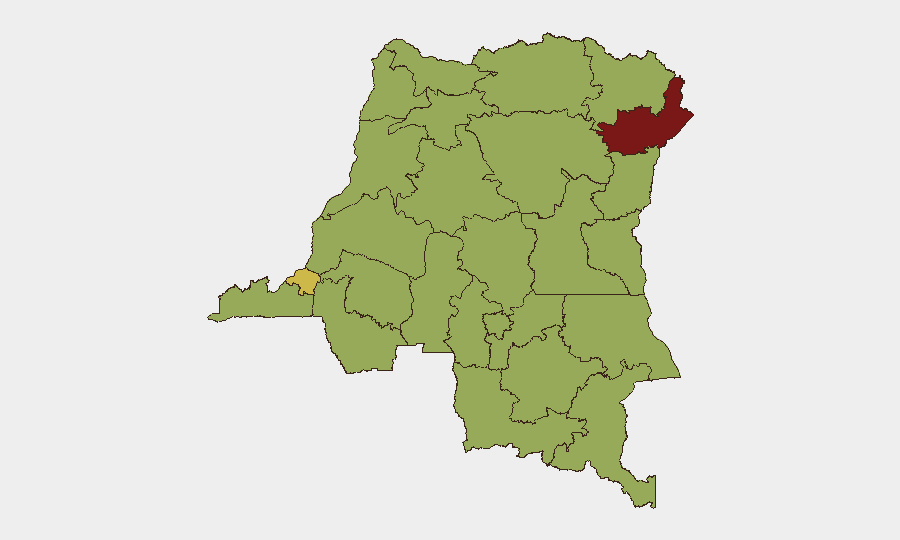
Ituri province dominates the sub-national risk ranking (88.9), reflecting concentrated armed-group activity, militia fragmentation, and weak state authority. Kinshasa (63.1) follows as the political and administrative hub, where elite competition and sporadic protest risk pose duty-of-care hazards. A secondary tier of nine provinces (Maniema, Sud-Ubangi, Équateur, Nord-Ubangi, Mongala, Lower Uele, Tshopo, Tshuapa, Upper Uele, North Kivu) all register 58.9, indicating sustained insurgency presence, militia activity, and limited security-force reach across much of the Congo Basin and northeastern regions. The concentration of elevated risk in the east and north reflects the geography of M23, ADF, and rival militia competition for territory and resources.
How GeoBit Would Assist
Security teams with personnel or assets in DR Congo should prioritize AOI Monitoring & Early Warning on Ituri, North Kivu, and Kinshasa to detect rapid escalation or displacement waves. Battle Mapping and Force Structure analysis enable real-time tracking of FARDC, M23, and ADF positions and capability shifts. Network & Actor Analysis combined with OSINT fusion & corroboration (Intel Sweep, Telegram/X OSINT, multi-language search) provides daily situational updates and early signals of policy shifts or new armed-group formations. Routing & Network Analysis supports contingency planning and non-standard transit in high-risk provinces.
7-Day Outlook
No major escalation is forecast over the next 7 days, but baseline risk will remain elevated. Diplomatic friction between Kinshasa and Kigali may produce rhetoric and limited posturing; eastern armed-group activity (M23, ADF, Wazalendo) is expected to persist at current operational tempo. Duty-of-care teams should maintain alert posture for displacement events, localized clashes, and potential disruptions to supply or personnel movement in Ituri and North Kivu.
Highest-Risk Areas — Ranked
| # | State / Region | Risk |
|---|---|---|
| 1 | Ituri | 88.9 |
| 2 | Kinshasa | 63.1 |
| 3 | Maniema | 58.9 |
| 4 | Sud-Ubangi | 58.9 |
| 5 | Équateur | 58.9 |
| 6 | Nord-Ubangi | 58.9 |
| 7 | Mongala | 58.9 |
| 8 | Lower Uele | 58.9 |
| 9 | Tshopo | 58.9 |
| 10 | Tshuapa | 58.9 |
| 11 | Upper Uele | 58.9 |
| 12 | North Kivu | 58.9 |
Sources
Previous Daily Briefs
A new DR Congo brief is written every day — each with its own risk map and downloadable CSV. Here's the last week; use the calendar to go further back.
📅 Browse every day by calendar →
Highlighted days have a brief. Tap a day for that day's map & analysis, or “csv” for that day's dataset ($5).
Atlas — our AI intelligence desk — emails them this snapshot personally. Nothing else, no list.