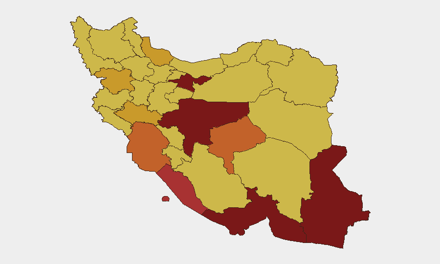
Situation Summary
Iran faces an acute military and infrastructure crisis following six days of sustained US airstrikes (16–19 July 2026) that have expanded from maritime targets in the Strait of Hormuz to widespread strikes on central and southern Iranian military, power, water, and telecommunications infrastructure. At least 50 civilian deaths have been reported over the past week, with critical damage to bridges, tunnels, desalination plants, and port facilities in Khuzestan, Hormozgan, and adjacent provinces. The conflict has spilled regionally, with Iranian retaliatory strikes killing two US soldiers in Jordan and Iranian forces actively targeting commercial shipping in the Gulf of Oman and Strait of Hormuz, creating compounding risks to supply chains, personnel mobility, and asset security.
Key Developments
- Southern Iranian infrastructure strikes (18 Jul): US airstrikes damaged bridges, tunnels, electricity distribution, and a desalination plant in southern Iran, cutting water supply to villages; civilian casualty toll reported at 50+ over the past week. [Khuzestan, Hormozgan provinces]
- Mahshahr water-pumping station hit (18 Jul): Agricultural water infrastructure in Khuzestan struck, killing station guard and injuring four; US Central Command confirmed concurrent strikes on air-defense systems, radar, and coastal capabilities. [Khuzestan Province]
- Hormozgan telecom and maritime targets (18 Jul overnight): Telecommunications facility employee killed and two wounded in Hormozgan; Iranian Navy lieutenant killed at Jask port in same overnight strike wave. [Hormozgan Province]
- Qeshm Island military strike (18 Jul): Over 10 projectiles hit Qeshm Island targeting military positions; no casualties reported but reflects sustained Strait of Hormuz campaign. [Hormozgan Province]
- Strait of Hormuz and coastal air-defense strikes (18 Jul): US strikes targeted Iranian air-defense systems and IRGC small boats to degrade anti-shipping capability; concurrent Iranian attacks on commercial vessels disabled at least one tanker. [Strait of Hormuz, Hormozgan Province]
- Cross-border Iranian missile and drone attack (17 Jul, reported 18 Jul): Iranian ballistic missiles and drones struck US military facilities in Jordan, killing two US soldiers and leaving one missing; US responded with additional airstrikes same day. [Jordan / spillover risk to Syria, broader Gulf]
- Commercial shipping strike off Oman (18 Jul): Cypriot-flagged vessel GFS Galaxy struck off Oman's coast; 23 crew rescued, one Indian national missing; Oman lodged formal protest against Iran. [Gulf of Oman]
Highest-Risk Areas
Tehran Province (risk 100) leads the ranking but current tactical danger concentrates in southern and southwestern provinces: Isfahan, Hormozgan, and Khuzestan (risks 91.4, 90.2, 74.5 respectively) are bearing the direct impact of strikes on military, infrastructure, and port facilities. Hormozgan's position controlling the Strait of Hormuz and hosting major naval/air-defense assets makes it the epicenter of US–Iran military confrontation. Khuzestan's critical role in water, electricity, and agricultural supply for the broader region amplifies spillover humanitarian and civil-unrest risks. Sistan and Baluchestan (80.4) and Bushehr (76.6) remain elevated due to coastal military concentrations and proximity to ongoing maritime conflict.
How GeoBit Would Assist
Security teams should deploy AOI Monitoring & Early Warning on Tehran Province, Khuzestan, Hormozgan, and key infrastructure nodes (ports, power plants, desalination facilities) to detect strike patterns and damage in near-real time. Satellite & Imagery Analysis and GIS & Spatial Analysis enable rapid damage assessment and alternative-route planning around newly damaged bridges and infrastructure. Maritime & Aviation Tracking combined with Routing & Network Analysis allow real-time rerouting of personnel and supply chains away from active Strait of Hormuz and Iranian coastal conflict zones.
7-Day Outlook
The escalation trajectory suggests continued US strikes on Iranian military and dual-use infrastructure through late July, with Iranian retaliatory attacks on regional US allies and commercial shipping. Personnel and asset movement in Khuzestan, Hormozgan, Isfahan, and the Strait of Hormuz corridor should be treated as high-risk; supply-chain disruption and potential further civilian infrastructure damage are probable. A ceasefire or negotiated pause is not currently signaled, making persistent monitoring and agile contingency routing essential for duty-of-care compliance.
Highest-Risk Areas — Ranked
| # | State / Region | Risk |
|---|---|---|
| 1 | Tehran Province | 100 |
| 2 | Isfahan Province | 91.4 |
| 3 | Hormozgan Province | 90.2 |
| 4 | Sistan and Baluchestan Province | 80.4 |
| 5 | Bushehr Province | 76.6 |
| 6 | Khuzestan Province | 74.5 |
| 7 | Yazd Province | 73.4 |
| 8 | Gilan Province | 71.4 |
| 9 | Lorestan Province | 71.3 |
| 10 | Kurdistan Province | 71 |
| 11 | Fars Province | 70.8 |
| 12 | Razavi Khorasan | 70.7 |
Sources
Previous Daily Briefs
A new Iran brief is written every day — each with its own risk map and downloadable CSV. Here's the last week; use the calendar to go further back.
📅 Browse every day by calendar →
Highlighted days have a brief. Tap a day for that day's map & analysis, or “csv” for that day's dataset ($5).
Atlas — our AI intelligence desk — emails them this snapshot personally. Nothing else, no list.