Situation Summary
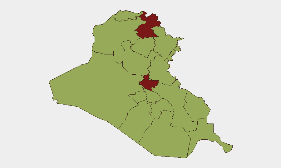
Iraq faces acute escalation driven by coordinated US–Saudi precision strikes against Iran-aligned militia positions on 28 July 2026, triggering immediate Iranian drone retaliation in northern Iraq and prompting an emergency security meeting by Prime Minister al-Zaydi. The strike sequence—targeting Hashd al-Shaabi infrastructure in Basra and dispersed Iranian-linked sites—represents direct third-party military intervention on Iraqi territory in response to regional drone attacks on Saudi energy facilities and US personnel. Risk environment has shifted from chronic insurgency (primary historical driver) to acute state-on-state and proxy escalation, with northern and central governorates now experiencing active air operations.
Key Developments
- Basra Governorate, Basra city – 28 July: Saudi armed forces conducted precision airstrikes on Hashd al-Shaabi headquarters, confirmed via visual media, in response to recent drone attacks on Saudi oil infrastructure.
- Multiple locations, Iraq-wide – 28 July: US Central Command announced coordinated US–Saudi precision strikes against Iran-aligned group positions accused of launching drone attacks on US forces and Saudi energy targets; scope and exact targets remain partially undisclosed.
- Baghdad (government level) – 29 July: Prime Minister Ali Faleh al-Zaydi convened urgent security meeting in direct response to foreign military strikes on Iraqi territory, signaling high-level concern over sovereignty and internal stability.
- Erbil Governorate, Kalifan and Soran districts – 28–29 July: At least four suspected Iranian drones struck areas northeast of Erbil, causing large fires at impact sites; two drones reportedly crashed near intended targets. US air defense and surveillance response included deployment of 10+ warplanes and drones over Erbil airspace.
- Erbil Governorate, near US Consulate – 28–29 July: Enhanced US military presence (10+ aircraft) reported airborne to monitor drone activity and protect US diplomatic installations following Iranian strike wave.
- Sulaymaniyah Governorate, Khor Mor gas field – 28–29 July: Attack reported on major natural-gas infrastructure in Iraqi Kurdistan, attributed to Iranian-linked drone operations as part of wider escalation cycle.
- Northern Iraq (Erbil region) – 28–29 July: Multiple explosions and suspected Iranian drone activity reported across northern Iraq, with US assets and coalition partners under direct threat from ongoing Iranian operations.
Highest-Risk Areas
Erbil and Baghdad governorates (both rated 80.6) are now the dominant risk drivers due to active air operations, foreign military strike activity, and presence of US diplomatic/military installations. Sulaymaniyah (58.2) elevated risk due to direct attacks on critical energy infrastructure and geographic proximity to Iranian border. Central and southern governorates (Babil, Wasit, Al-Anbar) remain elevated but secondary to the current kinetic focus in the north and capital. The sharp rise in conventional military force events—replacing typical insurgency/IED patterns—indicates structural shift in threat typology.
How GeoBit Would Assist
Security teams should employ AOI (area-of-interest) monitoring & early warning for Erbil, Baghdad, and Sulaymaniyah to detect incoming drone/missile activity and strike patterns with persistent alerting. Conflict & military tracking (force structure, weapons-capability, battle mapping) enables real-time assessment of US, Saudi, Iranian, and Iraqi military posture and movement. Intel Sweep and multi-language OSINT (X/Telegram, YouTube, regional media) provide rapid corroboration of strike claims, damage assessment, and militia statements ahead of official announcements.
7-Day Outlook
Risk of further tit-for-tat strikes remains high; Iranian retaliation for US–Saudi strikes may follow in 48–72 hours. Iraqi government response and de-escalation messaging will likely intensify, but sovereignty constraints limit Baghdad's ability to prevent foreign operations on its soil. Personnel in Erbil and Baghdad face elevated exposure through at least early August; critical infrastructure in the north (oil, gas) remains a secondary target set.
Highest-Risk Areas — Ranked
| # | State / Region | Risk |
|---|---|---|
| 1 | Erbil Governorate | 80.6 |
| 2 | Baghdad Governorate | 80.6 |
| 3 | Sulaymaniyah Governorate | 58.2 |
| 4 | Halabja Governorate | 51.2 |
| 5 | Babil Governorate | 50.6 |
| 6 | Wasit Governorate | 50.6 |
| 7 | Al-Qadisiyah Governorate | 50.6 |
| 8 | Dhi Qar Governorate | 50.6 |
| 9 | Al-Muthanna Governorate | 50.6 |
| 10 | Maysan Governorate | 50.6 |
| 11 | Al-Basra Governorate | 50.6 |
| 12 | Al-Anbar Governorate | 50.6 |
Sources
Previous Daily Briefs
A new Iraq brief is written every day — each with its own risk map and downloadable CSV. Here's the last week; use the calendar to go further back.
📅 Browse every day by calendar →
Highlighted days have a brief. Tap a day for that day's map & analysis, or “csv” for that day's dataset ($5).
Atlas — our AI intelligence desk — emails them this snapshot personally. Nothing else, no list.