Situation Summary
Mali remains classified as a high-threat environment (global rank #22, composite score 69) with insurgency as the primary driver. The security landscape is characterized by sustained armed-group activity in the north and center, compounded by recent government-military tensions and international diplomatic friction. Over the past 48 hours, escalating signals—including aerial weapons employment, territorial occupation claims involving Russian actors, and internal governance disapproval—suggest heightened volatility, though ground-truth confirmation of the newest incidents remains incomplete.
Key Developments
- Gao Region, 18–19 July: Malian army convoy ambushed near Anéfis/Tabankort corridor; FLA and JNIM claimed responsibility; estimated 50+ Malian military casualties reported by Reuters and international media; army conducted retaliatory airstrikes in response.
- Mali-wide, 22 July: Strike/boycott action and conventional military force event recorded; full operational details not independently confirmed by secondary sources as of 23 July 0800 UTC.
- Mali Internal, 23 July: Disapproval event logged (Mali vs. Mali), indicating intra-government or civil-military friction; context under clarification.
- Mali Airspace/Territory, 23 July: Aerial weapons employment and territory occupation events involving Russian Federation actors recorded; operational scope and civilian/military target distinction not yet verified.
- International Statement, 23 July: Public statements from Reuters and Washington on Mali situation; details indicate ongoing diplomatic concern but specific policy changes not yet detailed in available reports.
Highest-Risk Areas
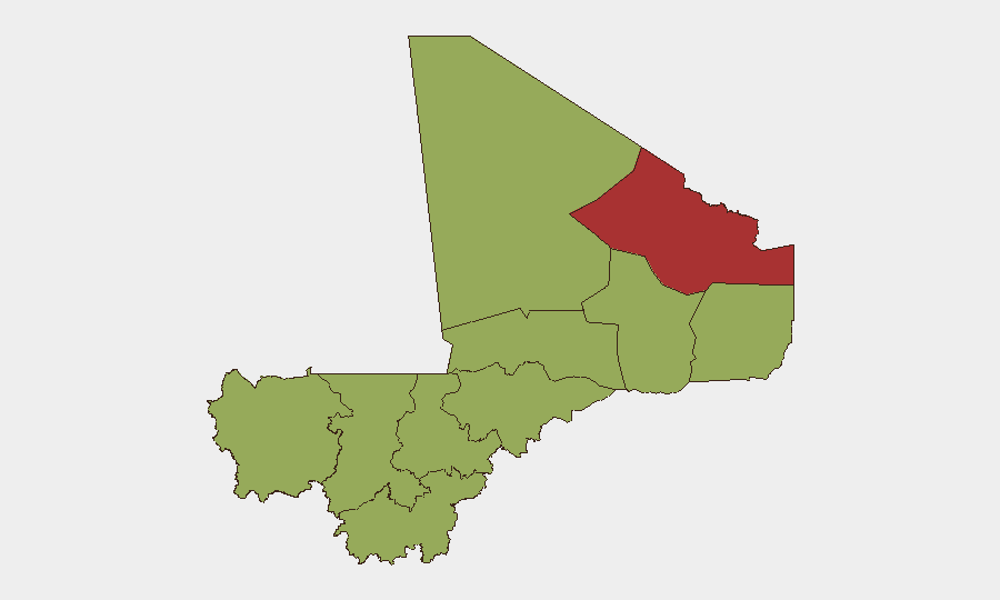
Kidal region dominates the threat landscape (risk 78.1), reflecting its status as a historical stronghold for Tuareg and Islamist armed groups and a zone of weak state control. Bamako (60.3), despite its capital status, ranks second due to insider-threat risk, governance instability, and international-actor presence. The Gao, Timbuktu, and Ségou regions form a contiguous high-risk belt across central-northern Mali, where JNIM, FLA, and splinter groups maintain operational freedom and frequently target military and civilian infrastructure. The recent 18–19 July ambush in Gao exemplifies this persistent vulnerability.
How GeoBit Would Assist
Corporate teams with Mali presence should deploy AOI (Area-of-Interest) Monitoring & Early Warning on Kidal, Gao, and Bamako to detect armed-group movement, military repositioning, and checkpoint activity in real time. Network & Actor Analysis and X/Twitter & Telegram OSINT capabilities enable rapid identification and verification of claimed attacks (e.g., FLA/JNIM statements) and differentiation of propaganda from confirmed incidents. Conflict & Military force-structure and battle-mapping tools help track the location and operational tempo of Malian forces and armed groups, informing travel-route risk and facility-security posture.
7-Day Outlook
The combination of recent military losses (Gao ambush), internal governance friction, and foreign-actor involvement signals a period of elevated unpredictability. Armed groups are likely to sustain pressure in the north and central regions, while government capacity constraints and international tensions may slow coordinated counteroffensive operations. Organizations should assume restricted movement corridors, potential roadblock proliferation, and elevated risk in Bamako (diplomatic/political) and the Gao–Timbuktu axis (insurgent activity) over the next 7 days.
Highest-Risk Areas — Ranked
| # | State / Region | Risk |
|---|---|---|
| 1 | Kidal | 78.1 |
| 2 | Bamako | 60.3 |
| 3 | Timbuktu | 50.5 |
| 4 | Ségou Region | 49.3 |
| 5 | Ménaka | 48.1 |
| 6 | Kayes | 48.1 |
| 7 | Taoudénit Region | 48.1 |
| 8 | Gao | 48.1 |
| 9 | Koulikoro | 48.1 |
| 10 | Sikasso Region | 48.1 |
| 11 | Mopti | 48.1 |
Sources
Previous Daily Briefs
A new Mali brief is written every day — each with its own risk map and downloadable CSV. Here's the last week; use the calendar to go further back.
📅 Browse every day by calendar →
Highlighted days have a brief. Tap a day for that day's map & analysis, or “csv” for that day's dataset ($5).
Atlas — our AI intelligence desk — emails them this snapshot personally. Nothing else, no list.