Situation Summary
Niger remains the 23rd highest-threat country globally (composite score 68) with 17 tracked events, reflecting persistent terrorism, intercommunal violence, and state fragility across its northern and eastern regions. Open-source monitoring over the last 24–48 hours reports no newly confirmed discrete incidents (attacks, protests, kidnappings, or infrastructure disruptions), though structural threat from armed groups and security-force instability remains elevated. The broader context—including a 16-soldier lethal ambush near Téra in Tillabéri Region on July 17—underscores sustained pressure on Defence and Security Forces (FDS) in the Sahel tri-border zone. Near-term risk trajectory is stable but contingent on militant activity in ungoverned spaces and state-force cohesion.
Key Developments
Last 24–48 hours (July 25–26, 2026):
- Countrywide – No new confirmed attacks or major security incidents reported in open-source monitoring (regional media, consular advisories, security-intelligence feeds) during the July 25–26 window, despite persistently high structural terrorism and violent-crime risk.
- Border/Regional diplomacy signals (Cotonou–Niger, Niger–Libya, Niger–Nigeria interactions logged in event stream) suggest ongoing inter-state coordination or tension, though specific tactical details remain under-reported in accessible sources.
- FDS detention/investigative activity noted across multiple signals (arrests, investigations, inter-agency checks) on July 26, consistent with ongoing security-force operations and internal-security protocols in response to prior threat events.
Context (outside 24–48h, for trajectory):
- July 17 Téra ambush (Tillabéri Region) resulted in 16 FDS killed, 23 wounded, with search-and-sweep operations continuing in the tri-border military zone.
Highest-Risk Areas
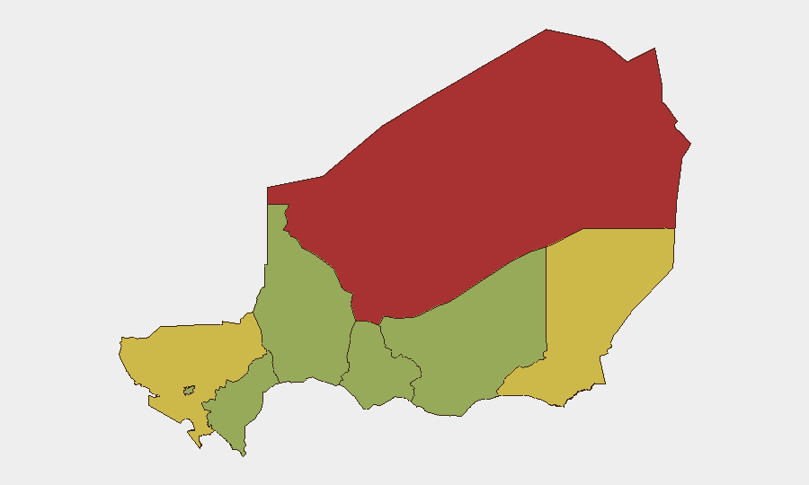
Agadez Region (77.2) and Diffa Region (66) drive Niger's sub-national risk, both hosting transnational militant networks, trafficking corridors, and weak state presence. Tillabéri Region (63.5)—site of the July 17 lethal FDS ambush—remains a kinetic hotspot along the Mali–Burkina Faso border, with IED and complex-attack risk. Niamey (51), while significantly lower-risk than the northern tier, faces urban crime, political tension, and potential for protest or security-force actions. Mid-range regions (Zinder, Tahoua, Dosso, Maradi: 47.2 each) show baseline terrorism and communal-conflict risk but have not recently driven major incidents.
How GeoBit Would Assist
AOI Monitoring & Early Warning with persistent watch on Agadez, Diffa, and Tillabéri would detect FDS movements, militant activity resurgence, or cross-border incursions in near-real time. Conflict & Military tools (battle mapping, force-structure tracking, weapons-capability intelligence) enable security teams to model FDS operational capacity and threat-actor disposition in the tri-border zone. Intel Sweep (global event feeds, multi-language OSINT fusion, Telegram/X monitoring, sentiment analysis) would surface emerging protest, detention, or inter-agency signals days ahead of public reporting, sharpening duty-of-care decisions for personnel in Niamey or field locations.
7-Day Outlook
No major escalation is indicated in the immediate 7-day window based on current open-source absence of new discrete incidents. Underlying risk remains high in Agadez, Diffa, and Tillabéri—FDS operations in response to the July 17 Téra attack will likely continue, with potential for secondary contacts or detention cycles. Vigilance on border-zone activity and any state-force reorganization is warranted; changes in FDS disposition or militant tactical shifts should be monitored via OSINT and imagery to anticipate shifts in risk landscape.
Highest-Risk Areas — Ranked
| # | State / Region | Risk |
|---|---|---|
| 1 | Agadez Region | 77.2 |
| 2 | Diffa Region | 66 |
| 3 | Tillabéri Region | 63.5 |
| 4 | Niamey | 51 |
| 5 | Zinder Region | 47.2 |
| 6 | Tahoua Region | 47.2 |
| 7 | Dosso Region | 47.2 |
| 8 | Maradi Region | 47.2 |
Sources
Previous Daily Briefs
A new Niger brief is written every day — each with its own risk map and downloadable CSV. Here's the last week; use the calendar to go further back.
📅 Browse every day by calendar →
Highlighted days have a brief. Tap a day for that day's map & analysis, or “csv” for that day's dataset ($5).
Atlas — our AI intelligence desk — emails them this snapshot personally. Nothing else, no list.