Situation Summary
South Sudan remains in active armed conflict, with composite threat ranking of 65 globally. The security environment in the past 48 hours has been marked by two major incidents: a large-scale cross-border cattle raid killing 49 civilians in Warrap State and an ambush on a UN peacekeeping patrol in Jonglei State that killed two Ethiopian peacekeepers. These events underscore persistent armed group mobility, inter-communal violence, and deteriorating security along key transport corridors, particularly in the north and northeast.
Key Developments
- Tonj North County, Warrap State – 27 August 2026 (0500 hrs local time). Armed cattle raiders from Unity State attacked Machar-Pakuek cattle camp and Mading Juer Boma in Majak Payam, killing at least 49 people and wounding 33 in a large-scale raid. Warrap State officials characterized the attack as "brutal" and highlighted the cross-border nature of the assault.
- Warrap–Unity border corridor – 27–28 August 2026 (assessment updated). Intelligence and local reporting confirm that multiple armed groups maintain sufficient mobility and firepower to conduct coordinated, large-scale raids across state boundaries. Risk of retaliatory or follow-on attacks in this corridor assessed as acute.
- Bor–Pajut corridor, Jonglei State – 24 August 2026 (ambush); 27–28 August (diplomatic response and security advisories updated). A UNMISS patrol was ambushed approximately 10 km from Jalle, resulting in two UN peacekeepers killed and seven injured (three peacekeepers, two South Sudan National Police Service officers, two UN staff). The UN Security Council issued a condemnation statement on 27–28 August calling for investigation and accountability.
- Jonglei State – 26–28 August 2026 (UNMISS response operations). A UN Quick Reaction Force was deployed to the ambush site; wounded personnel evacuated by air. UNMISS patrol procedures have been reviewed. Heightened military presence and operational caution now evident along key routes in Jonglei.
- Bor–Pajut corridor, Jonglei State – Status as of 28 August 2026. This corridor remains under explicit, multi-source security advisory as high-risk for convoy and humanitarian movement. The ambush and subsequent international response have reinforced travel warnings for this route.
Highest-Risk Areas
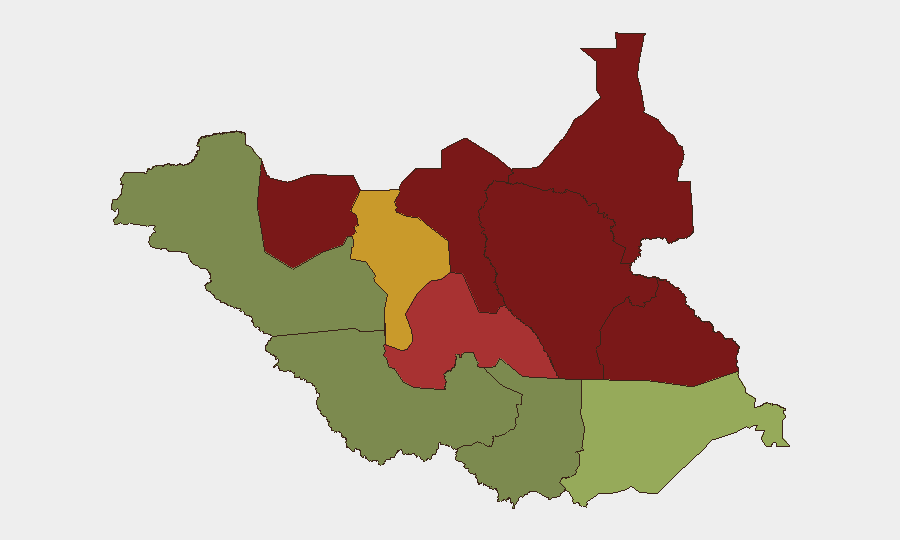
Unity State (risk 95) and Jonglei State (risk 93) are the primary drivers of national risk. The Tonj North attack underscores Unity's role as a source of armed raiding capacity; Jonglei's risk is compounded by its position as a transit zone and the recent ambush on international peacekeeping forces. Upper Nile (risk 88) and Greater Pibor Administrative Area (risk 87) remain endemic conflict zones. In contrast, Central Equatoria (risk 35) and Western Equatoria (risk 38) show substantially lower threat profiles, reflecting greater stability in the south and west.
How GeoBit Would Assist
Conflict & Military analysis (battle mapping, force-structure tracking) and AOI Monitoring & Early Warning would enable security teams to track armed group positions and movements across the Warrap–Unity border and detect indicators of follow-on raiding activity. Routing & Network Analysis capabilities would support convoy planning and identification of safer alternative routes in Jonglei and other high-risk corridors. Intel Sweep (multi-language OSINT, Telegram/X intelligence) would provide real-time sentiment tracking and crowd-sourced incident confirmation to supplement official briefings.
7-Day Outlook
Armed group activity and inter-communal raiding are likely to persist in northern states (Warrap, Unity, Jonglei) without marked de-escalation. Retaliatory attacks from Warrap-based communities against Unity State actors are a credible near-term risk. Security along the Bor–Pajut corridor will remain constrained pending investigation results and any changes to UNMISS patrol posture.
Highest-Risk Areas — Ranked
| # | State / Region | Risk |
|---|---|---|
| 1 | Unity | 95 |
| 2 | Jonglei | 93 |
| 3 | Upper Nile | 88 |
| 4 | Greater Pibor Administrative Area | 87 |
| 5 | Northern Bahr el Ghazal | 82 |
| 6 | Lakes | 78 |
| 7 | Warrap | 72 |
| 8 | Ruweng Administrative Area | 68 |
| 9 | Eastern Equatoria | 52 |
| 10 | Western Equatoria | 38 |
| 11 | Central Equatoria | 35 |
| 12 | Western Bahr el Ghazal State | 28 |
Sources
Previous Daily Briefs
A new South Sudan brief is written every day — each with its own risk map and downloadable CSV. Here's the last week; use the calendar to go further back.
- August 26, 2026
- August 24, 2026
- August 22, 2026
- August 20, 2026
- August 18, 2026
- August 16, 2026
- August 14, 2026
📅 Browse every day by calendar →
Highlighted days have a brief. Tap a day for that day's map & analysis, or “csv” for that day's dataset ($5).
Atlas — our AI intelligence desk — emails them this snapshot personally. Nothing else, no list.