Situation Summary
Sudan remains in active civil war with composite threat score 98 (rank #2 globally), driven by sustained conventional military operations, drone strikes, and the collapse of state security in urban centers. The last 24–48 hours show concurrent escalation across three distinct operational zones: renewed SAF mopping-up and air operations in North Kordofan; a documented spike in armed gang violence and urban crime in Khartoum and secondary cities; and RSF advances with drone strikes across Blue Nile, White Nile, and Darfur border areas. Infrastructure failure (power, water) in Port Sudan and critical travel corridors underscores both direct combat risk and systemic fragility affecting business continuity and personnel safety.
Key Developments
- El Obeid–Khartoum corridor, North Kordofan (29–30 July): SAF drone strikes and mopping-up operations ongoing along Al Sadarat highway west of El Obeid; multiple vehicle fires and explosions geolocated by monitors around Bara and Um Sayala, confirming active combat and degraded travel safety on major export route.
- Southern Omdurman, Al-Salha district (night 29–30 July): Armed robbery and home-invasion spike reported by local community accounts; at least one fatality documented in armed robberies, with armed gangs operating in security vacuum and law enforcement absent from peripheral districts.
- Rabak, White Nile State (late 29 July): Lethal gang attacks and armed robberies in town center and residential quarters; one confirmed death (Bahaa el‑Din Mohamed, age 30) during home robbery, indicating persistent night-time crime risk in secondary urban centers.
- Port Sudan, Red Sea State (29–30 July): Near-total electrical outages and water shortages across neighborhoods for 24+ hours; port operations partially halted due to extreme heatwave and infrastructure collapse, affecting logistics and personnel duty-of-care (heat exposure, water access).
- Tina and Sudan–Chad border, North/West Darfur (29–30 July): Continued drone strikes around twin towns of Tina with 21+ reported fatalities in North Darfur; strikes documented on civilian sites in Chad; both RSF and joint forces massing for anticipated larger engagement.
- Blue Nile and White Nile corridors (29–30 July): RSF advances on state positions with concurrent drone strikes on civilian vehicles and settlements; reported casualties among displaced persons and traders, indicating heightened movement risk across river corridors and civilian routes.
Highest-Risk Areas
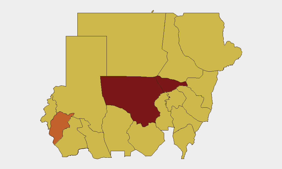
North Kordofan State (98.4) and Al Khartum (80.9) dominate the sub-national ranking, driven by concurrent SAF conventional operations and urban collapse respectively. North Kordofan's extreme score reflects active drone, artillery, and ground operations along critical supply lines; Khartoum's reflects the documented security vacuum in peripheral districts, gang activity, and infrastructure failure. Central Darfur (74.2) and the river-state corridor (White Nile, Blue Nile, River Nile, each 68.4) remain elevated due to RSF mobility, drone capability, and displacement; Red Sea, Kassala, Sennar, and South Darfur maintain similar baseline threat levels (68.4), indicating persistent operational tempo across the periphery.
How GeoBit Would Assist
Security teams managing personnel or assets in Sudan should deploy AOI Monitoring & Early Warning on North Kordofan travel corridors and Khartoum peripheral districts to capture drone-strike and crime incidents in near-real time. Battle mapping and force-structure tracking paired with routing and alternative-journey planning enable duty-of-care teams to identify safe corridors and timing for movement; satellite imagery and OSINT fusion (X, Telegram, local media) provide independent corroboration of infrastructure status and conflict spread without reliance on military or government statements.
7-Day Outlook
Drone operations and ground advances are likely to persist along the Kordofan corridor and Darfur border through early August, with SAF consolidation competing against RSF maneuver. Urban crime and infrastructure collapse in Khartoum and secondary cities will remain elevated absent police redeployment, increasing robbery and assault risk for non-essential movement. Port Sudan and the Blue Nile–White Nile corridor should be monitored for RSF operational momentum and further displacement.
Highest-Risk Areas — Ranked
| # | State / Region | Risk |
|---|---|---|
| 1 | North Kordofan State | 98.4 |
| 2 | Al Khartum | 80.9 |
| 3 | Central Darfur State | 74.2 |
| 4 | White Nile | 68.8 |
| 5 | Blue Nile | 68.4 |
| 6 | River Nile State | 68.4 |
| 7 | Aj Jazira | 68.4 |
| 8 | Red Sea State | 68.4 |
| 9 | Al Qadarif State | 68.4 |
| 10 | Kassala State | 68.4 |
| 11 | Sennar State | 68.4 |
| 12 | South Darfur State | 68.4 |
Sources
Previous Daily Briefs
A new Sudan brief is written every day — each with its own risk map and downloadable CSV. Here's the last week; use the calendar to go further back.
📅 Browse every day by calendar →
Highlighted days have a brief. Tap a day for that day's map & analysis, or “csv” for that day's dataset ($5).
Atlas — our AI intelligence desk — emails them this snapshot personally. Nothing else, no list.