Situation Summary
Syria remains the 7th highest-threat country globally (composite score 96), driven by ongoing civil war and fragmented state control. The security environment is characterized by inter-communal violence, targeted killings, infrastructure disruptions, and detainee-related civil unrest across multiple governorates. Recent fatality counts (17 confirmed deaths in the week ending 22 July) suggest sustained but non-catastrophic violence driven partly by vigilantism and transitional-justice tensions. The trajectory remains volatile with localized escalation risk, particularly in Damascus and Hama.
Key Developments
- Raqqa Countryside (23 July): One killed and two injured in a landmine explosion, highlighting persistent explosive hazards across former conflict zones.
- Hasakah Governorate—Tel Tamer (23 July): Main roads blocked in protest over obstruction of a convoy to the Alouk water station, indicating civil unrest linked to infrastructure access and control.
- Hasakah Governorate—Alouk Water Station (23 July): Water flow resumption reported, following earlier disruption; infrastructure vulnerability remains a flash point for inter-communal tensions.
- Hasakah Governorate—Qamishlo (23 July): Families of detainees protested demanding prisoner releases, reflecting ongoing civil-unrest pressure around accountability and transitional justice.
- Quneitra Governorate (23 July): Protest demanding information on detainee fates; consistent with broader pattern of civil unrest over missing-persons accountability.
- Deir ez-Zor and Aleppo Provinces (21 July): Two killed and seven injured across four tribal clashes, indicating inter-communal conflict in eastern and northern zones.
Highest-Risk Areas
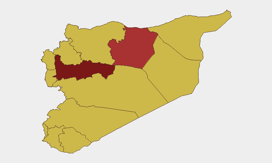
Damascus Governorate (97.2) and Hama Governorate (93.4) dominate the risk ranking and remain the primary focal points for monitoring. Both face compounded threats: state fragmentation, presence of multiple armed actors, and civilian unrest around detentions and accountability. The eastern corridor—Ar-Raqqa (76.5), Deir ez-Zor (70.6), and Hasakah (tracked separately within provincial figures)—exhibits sustained inter-communal and tribal violence, landmine hazards, and control-of-infrastructure disputes. Coastal and border zones (Lattakia, Tartus, UNDOF, Al-Quneitra, Dar'a) remain elevated due to cross-border dynamics and territorial ambiguity; Idleb and Aleppo (both 67.4) face civilian volatility and economic stress. Water infrastructure (Alouk) and detainee accountability are emerging tactical flash points across multiple regions.
How GeoBit Would Assist
Security teams managing personnel or assets in Syria should deploy AOI Monitoring & Early Warning on high-risk governorates (Damascus, Hama, Hasakah) to trigger alerts on violence escalation, infrastructure disruptions, and protest activity in real time. Conflict & Military mapping combined with Network & Actor Analysis will identify shifting control zones, tribal/factional boundaries, and safe-passage corridors. OSINT fusion (X/Telegram, local news feeds, multi-language analysis) provides 24–48-hour lead time on civil unrest and detention events, reducing surprise. Routing & Network Analysis supports dynamic journey planning away from landmine zones and protest areas. Satellite & Imagery assists in assessing infrastructure integrity (water stations, roads) and force positioning near corporate or humanitarian operations.
7-Day Outlook
No imminent major military escalation is indicated, but localized violence—tribal clashes, vigilante killings, and civil unrest—will likely persist and spike around detainee/transitional-justice triggers. Water and infrastructure disruptions will remain vectors for inter-communal tension and road blockades. Risk of secondary incidents (landmines, protest violence) remains elevated in eastern and northern governorates through end-July.
Highest-Risk Areas — Ranked
| # | State / Region | Risk |
|---|---|---|
| 1 | Damascus Governorate | 97.2 |
| 2 | Hama Governorate | 93.4 |
| 3 | Ar-Raqqa Governorate | 76.5 |
| 4 | Deir ez-Zor Governorate | 70.6 |
| 5 | Idleb Governorate | 67.4 |
| 6 | Aleppo Governorate | 67.4 |
| 7 | As-Suweida Governorate | 67.4 |
| 8 | Lattakia Governorate | 67.2 |
| 9 | Tartus Governorate | 67.2 |
| 10 | UNDOF | 67.2 |
| 11 | Al-Quneitra Governorate | 67.2 |
| 12 | Dar'a Governorate | 67.2 |
Sources
Previous Daily Briefs
A new Syria brief is written every day — each with its own risk map and downloadable CSV. Here's the last week; use the calendar to go further back.
📅 Browse every day by calendar →
Highlighted days have a brief. Tap a day for that day's map & analysis, or “csv” for that day's dataset ($5).
Atlas — our AI intelligence desk — emails them this snapshot personally. Nothing else, no list.