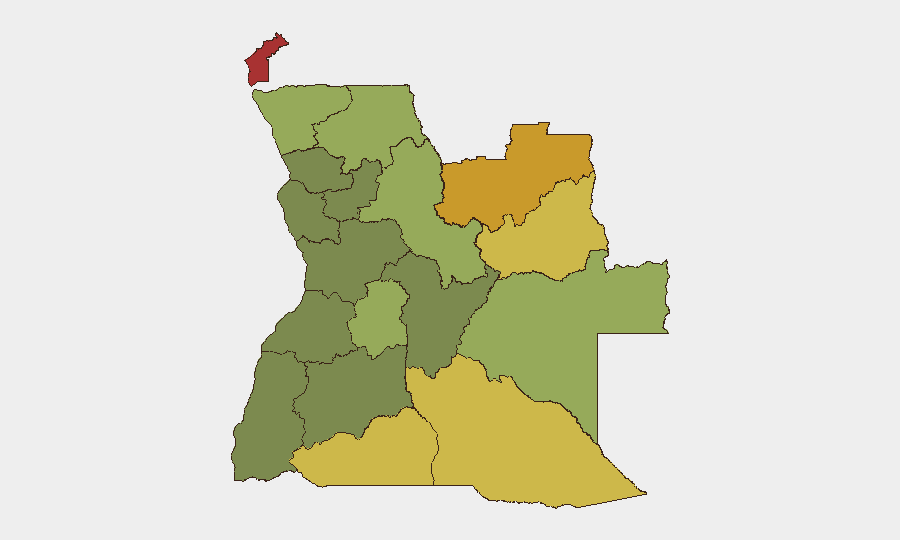
Situation Summary
Angola maintains a moderate composite threat profile (global rank #45, score 40) with civil unrest as the primary driver, but no acute escalation has been detected in the past 24–48 hours. The security environment remains shaped by political friction between the ruling MPLA and opposition UNITA, localized resource-conflict dynamics in eastern provinces, and routine urban criminality. Active forest fires across multiple provinces present a secondary infrastructure and travel-disruption risk as of 23 August 2026. Overall trajectory is stable at baseline conditions with no confirmed spike in violence, arrests, or protests in the immediate period.
Key Developments
- Forest fire hotspots – Angola (multi-province) – 23 August 2026: Live satellite fire tracking detected 10 active forest fire hotspots on 23 August 2026, with additional fire notifications on 21–22 August, indicating ongoing wildfire activity. Exact provinces and damage assessment unavailable; primary concern is smoke, visibility degradation on rural routes, and potential utility/infrastructure disruption.
- Telecom service stability – nationwide – as of 21 August 2026: UNITEL (major mobile operator) confirmed restoration of core services nationwide following a July cyberattack. Voice, messaging, data, and internet were operational as of 21 August; no new outages reported in the 22–23 August window.
- No verified new security or civil-unrest incidents – nationwide – 22–23 August 2026: Available corroborated reporting does not document new violence, arrests, mass protests, or police actions in the past 24–48 hours. The most recent substantive incident remains the 8 August UNITA gathering dispersal in Uíge Province (tear gas, rubber bullets, injuries), with follow-on legal complaints filed 20 August but no new escalation detected.
- Baseline political and police-authority context – nationwide – as of 18 August 2026: Policy clarification indicates provincial National Police commanders may now deploy the Rapid Intervention Police (PIR) in high-risk situations to restore order, with post-action notification to national command. This reflects operational adjustment rather than an imminent crisis.
Highest-Risk Areas
Cabinda Province (risk 78) and the two Lunda provinces (72, 68) remain Angola's highest-risk sub-national zones, driven by resource competition, armed-group presence, and weak state capacity. Cuando Cubango, Cunene, and Moxico provinces (risk 64, 62, 58) compound eastern/southeastern instability. These regions' elevated scores reflect underlying separatism, illegal mining, trafficking, and periodic intercommunal violence rather than imminent organized attacks. Central and northern zones (Huambo, Uíge, Malanje) show moderate risk (42–50), primarily linked to political friction and police response to opposition activity.
How GeoBit Would Assist
Teams with personnel or assets in Angola should deploy AOI Monitoring & Early Warning on high-risk provinces (Cabinda, Lunda Norte/Sul, Cuando Cubango) to detect emerging protest, armed activity, or trafficking networks in real time. OSINT fusion (multi-language social media, radio SIGINT, opposition party statements) would track political friction and police posture shifts, particularly around Luanda and Uíge. Satellite & imagery analysis combined with Environmental & Health monitoring can quantify forest fire extent and smoke impact on road networks and communities, informing duty-of-care decisions on travel and supply-chain routing.
7-Day Outlook
No significant escalation is expected in the next 7 days absent new triggers (e.g., opposition rally announcements, resource-driven violence in the east, or police crackdowns). Forest fires may persist or spread depending on weather; continued smoke could degrade visibility and disrupt rural logistics. Political tension remains a structural risk, particularly as opposition activities resume, but baseline security conditions are likely to hold through late August.
Highest-Risk Areas — Ranked
| # | State / Region | Risk |
|---|---|---|
| 1 | Cabinda Province | 78 |
| 2 | Lunda Norte Province | 72 |
| 3 | Lunda Sul Province | 68 |
| 4 | Cuando Cubango Province | 64 |
| 5 | Cunene Province | 62 |
| 6 | Moxico Province | 58 |
| 7 | Zaire Province | 54 |
| 8 | Huambo Province | 50 |
| 9 | Uíge Province | 48 |
| 10 | Malanje Province | 42 |
| 11 | Bié Province | 35 |
| 12 | Huíla Province | 32 |
Sources
Previous Daily Briefs
A new Angola brief is written every day — each with its own risk map and downloadable CSV. Here's the last week; use the calendar to go further back.
- August 21, 2026
- August 19, 2026
- August 17, 2026
- August 15, 2026
- August 13, 2026
- August 11, 2026
- August 9, 2026
📅 Browse every day by calendar →
Highlighted days have a brief. Tap a day for that day's map & analysis, or “csv” for that day's dataset ($5).
Atlas — our AI intelligence desk — emails them this snapshot personally. Nothing else, no list.