Situation Summary
DR Congo remains at elevated composite threat level (#9 globally, score 95) driven primarily by active insurgency and armed conflict in eastern provinces, compounded by a rapidly worsening national Ebola outbreak. Open-source reporting for the last 24–48 hours lacks discrete, time-stamped incident documentation at the specific-location level; however, underlying conflict dynamics in North Kivu, South Kivu, and political tensions in Kinshasa remain unresolved. The epidemiological emergency—confirmed cases and deaths rising sharply as of 25 July—materially increases operational risk across the country via movement restrictions and healthcare system strain.
Key Developments
- Kinshasa – Political tension signals (26–27 July). Government and Rwandan authorities exchanged disapprovals on 26 July; a Democratic Republic statement was issued 27 July. No specific civil unrest or security incident was documented in the last 24–48 hours, but diplomatic friction signals potential escalation risk in the capital and border regions.
- Eastern DRC (North & South Kivu) – Ongoing armed conflict without discrete incident dating (as of 24 July). Wazalendo pro-government forces and M23-aligned militias continue clashes near Masisi, Walikale, and Kalehe districts and around Minembwe (South Kivu), but available open-source feeds do not isolate specific attacks or clashes to the 25–26 July window; reporting aggregates multi-day operations.
- M23-controlled territories – Continued civilian abuse (ongoing into late July). UN human rights experts publicly condemned M23's "reign of terror," including systematic sexual violence, torture, and killings, but the statement reflects persistent patterns rather than a specific incident in the last 24–48 hours.
- National Ebola outbreak – Deaths and cases surging (data released 25 July). Confirmed Ebola deaths rose above 1,309 and total confirmed cases reached 2,973 as of 25 July—a sharp week-over-week increase. Kisangani (Tshopo Province) reported two confirmed cases with new biosecurity controls in place. This is the most clearly recent development affecting nationwide operational risk.
- No verified discrete security incidents in last 24–48 hours. Despite active conflict in the east and political tension in Kinshasa, open-source OSINT (news, X/Twitter, specialist security feeds) did not yield multi-source-confirmed incidents with specific location and time stamp within the 25–26 July window. Real-time incident reporting remains sparse.
Highest-Risk Areas
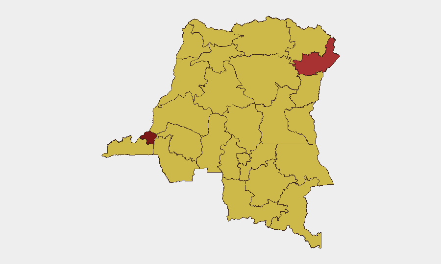
Kinshasa (96.7) ranks as the single highest-risk sub-national zone, reflecting both political volatility and the capital's role as a national chokepoint; recent diplomatic friction with Rwanda elevates concern there. Eastern provinces—Ituri (76.7), Maniema (66.7), North Kivu (66.7), and South Kivu (not separately ranked but operationally critical)—remain driven by active armed insurgency, M23 and Wazalendo militia clashes, and ongoing civilian harm. Northern and central regions (Équateur, Mongala, Tshopo, Tshuapa) score high due to Ebola spread, limited state authority, and insecurity-driven health emergency compounding. The concentration of risk in Kinshasa and the eastern corridor reflects both conflict intensity and governance capacity constraints.
How GeoBit Would Assist
Security teams monitoring DR Congo would deploy AOI Monitoring & Early Warning on Kinshasa (political tension), eastern conflict zones (North/South Kivu), and Ebola hotspots (Kisangani, Tshopo) for discrete incident alerting and trend detection. Intel Sweep and multi-language OSINT fusion across news, social media, and regional security feeds would close gaps in open-source incident-level reporting. Conflict & Military battle mapping and force-structure tracking would clarify M23 and Wazalendo positions and intentions; Routing & Network Analysis would enable alternative route planning around active combat zones and Ebola-control checkpoints.
7-Day Outlook
Political friction between Kinshasa and Kigali may intensify without de-escalation; monitor for border military posturing or rhetoric escalation. Eastern insurgency and militia clashes will likely continue at current tempo given M23's territorial hold and Wazalendo's sustained counter-offensive, with Minembwe and the Masisi–Walikale corridor remaining flashpoints. The Ebola outbreak trajectory remains the most predictable near-term risk driver; additional cases and movement restrictions are probable.
Highest-Risk Areas — Ranked
| # | State / Region | Risk |
|---|---|---|
| 1 | Kinshasa | 96.7 |
| 2 | Ituri | 76.7 |
| 3 | Maniema | 66.7 |
| 4 | Sud-Ubangi | 66.7 |
| 5 | Équateur | 66.7 |
| 6 | Nord-Ubangi | 66.7 |
| 7 | Mongala | 66.7 |
| 8 | Lower Uele | 66.7 |
| 9 | Tshopo | 66.7 |
| 10 | Tshuapa | 66.7 |
| 11 | Upper Uele | 66.7 |
| 12 | North Kivu | 66.7 |
Sources
Previous Daily Briefs
A new DR Congo brief is written every day — each with its own risk map and downloadable CSV. Here's the last week; use the calendar to go further back.
📅 Browse every day by calendar →
Highlighted days have a brief. Tap a day for that day's map & analysis, or “csv” for that day's dataset ($5).
Atlas — our AI intelligence desk — emails them this snapshot personally. Nothing else, no list.