Situation Summary
Iran is engaged in active, sustained military operations across multiple regional theaters—striking US-linked facilities in Kuwait, Bahrain, and Jordan while simultaneously absorbing significant US airstrikes on its own territory. Civilian casualties now exceed 50 dead over the past week, with infrastructure damage concentrated in southern coastal provinces. The conflict is characterized by tit-for-tat escalation with no ceasefire indicators, creating acute risk to personnel and assets across Iran's most developed and strategically important regions.
Key Developments
- Ahvaz, Khuzestan Province – 19 July 2026
Iranian IRGC shot down a US MQ-9 drone over the major industrial city using newly deployed air-defense systems, confirming active air operations over a civilian population center.
- Bandar Abbas–Sirjan road tunnel, Hormozgan Province – 19 July 2026
US airstrikes damaged critical transport infrastructure; tunnel was rapidly repaired and reopened, but indicates sustained targeting of southern supply routes.
- Qeshm Island, Bandar Abbas, and Khuzestan coastal belt – 18–19 July 2026
Multiple confirmed US strikes against Iranian missile, drone, and coastal defense sites; at least 30 killed and over 260 wounded in southern regions per Iranian government statement.
- Kuwait (Camp al-Adiri, Ali al-Salem Air Base) – 19 July 2026
Iran's IRGC claimed successful drone and missile strikes on US ammunition depots and air-defense systems in Kuwait, signaling operational reach beyond Iran's borders.
- Bahrain and Prince Hassan Air Base, Jordan – night of 18–19 July 2026
Iran's IRGC reported strikes on US military facilities in Bahrain and Jordanian ammunition/fuel depots; interception alerts and missile sirens activated across Gulf airspace.
- Bandar Abbas, Sirik, Bushehr ports – 18–19 July 2026
Confirmed US strikes on Iranian port infrastructure and maritime defense systems affecting Strait of Hormuz transit and coastal urban populations.
Highest-Risk Areas
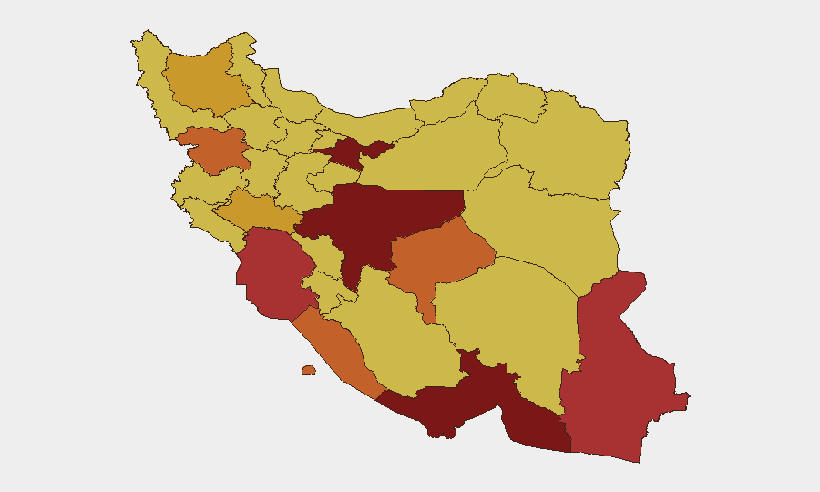
Tehran Province (risk 100) remains the administrative and intelligence nexus; however, operational risk is concentrated in southern and southwestern Iran: Isfahan (92), Hormozgan (91.4), Khuzestan (76.6), and Bushehr (74.7) face direct exposure to US air operations, maritime strikes, and civilian infrastructure damage. Hormozgan—home to Bandar Abbas, the Strait of Hormuz, and critical shipping infrastructure—is simultaneously under active bombardment and serving as a transit point for military retaliation. Khuzestan's major industrial cities (Ahvaz, Abadan) and energy infrastructure present dual risk: air-defense engagement zones and secondary-effects from strikes on nearby missile sites. These four provinces account for the majority of reported casualties and infrastructure damage in the past 48 hours.
How GeoBit Would Assist
Security teams should employ Battle Mapping and Force Structure tracking to monitor real-time US and Iranian air operations, AOI Monitoring with persistent alerts on high-risk provinces (Hormozgan, Khuzestan, Isfahan) to detect new strikes or IRGC activity, and Satellite & Imagery analysis to assess damage to ports, tunnels, and industrial assets affecting personnel safety and supply chains. Routing & Network Analysis capabilities enable identification of alternative transport corridors as primary infrastructure sustains damage. Intel Sweep and cross-platform OSINT fusion provide early warning of imminent strike patterns before tactical execution.
7-Day Outlook
Barring diplomatic intervention, US-Iran military exchanges will likely continue cycling at current intensity or escalate further. Civilian risk in Hormozgan, Khuzestan, and Isfahan provinces will remain acute. Regional allies (UAE, Oman, commercial shipping) face spillover risk from retaliatory strikes and air-defense engagements.
Highest-Risk Areas — Ranked
| # | State / Region | Risk |
|---|---|---|
| 1 | Tehran Province | 100 |
| 2 | Isfahan Province | 92 |
| 3 | Hormozgan Province | 91.4 |
| 4 | Sistan and Baluchestan Province | 79.5 |
| 5 | Khuzestan Province | 76.6 |
| 6 | Bushehr Province | 74.7 |
| 7 | Yazd Province | 73.3 |
| 8 | Kurdistan Province | 73 |
| 9 | East Azerbaijan Province | 71.8 |
| 10 | Lorestan Province | 71.4 |
| 11 | Alborz Province | 70.8 |
| 12 | Razavi Khorasan | 70.7 |
Sources
Previous Daily Briefs
A new Iran brief is written every day — each with its own risk map and downloadable CSV. Here's the last week; use the calendar to go further back.
📅 Browse every day by calendar →
Highlighted days have a brief. Tap a day for that day's map & analysis, or “csv” for that day's dataset ($5).
Atlas — our AI intelligence desk — emails them this snapshot personally. Nothing else, no list.