Situation Summary
Iraq faces acute escalation in US–Iran proxy conflict following coordinated US–Saudi airstrikes on July 28–29 against Popular Mobilization Forces (PMF) and Iran-aligned militant positions across seven provinces. The Iraqi government has responded by convening an emergency National Security Council meeting, condemning the strikes as sovereignty violations, and directing the Foreign Ministry to pursue international legal remedies. This marks a critical inflection point: while Baghdad maintains formal policy neutrality, the convergence of cross-border military action, domestic PMF mobilization, and weak state enforcement capacity creates heightened risk of secondary escalation, sectarian friction, and collateral exposure to civilian and international populations.
Key Developments
- Eastern Iraq (multiple provinces: Baghdad, Wasit, Nineveh, Basra, Kirkuk, Karbala, Diyala) – Night of July 28–29, 2026: US and Saudi fighter jets conducted precision airstrikes on IRGC-directed militant logistics and weapons facilities in response to over 30 drone attacks on US forces and Saudi energy infrastructure in the prior 72 hours. PMF and Iraqi media sources report at least 20 fighters killed and 30+ wounded across the seven-province footprint.
- Baghdad – July 29, 2026: Prime Minister Ali Falih al-Zaidi convened an emergency National Security Council meeting and publicly condemned the US–Saudi strikes as violations of Iraqi sovereignty, ordering a new integrated security plan to prevent further territorial breaches.
- Baghdad (Foreign Ministry) – July 29, 2026: Iraqi government directed formal documentation of the attacks and initiation of international legal proceedings to assert Iraq's rights, while reaffirming commitment to weapons centralization and regional non-alignment.
- Erbil area – Late July 28–Early July 29, 2026: Explosive-laden drones were launched toward a coalition-hosted base near Erbil; coalition air defenses intercepted multiple drones with no reported casualties or damage, occurring within the same escalation window.
- Regional posture – July 30, 2026: Simultaneous threat signals from Iran toward Iraq and Iraq toward Iran documented on social and official channels, indicating bilateral political messaging in wake of strikes.
- Administrative response – July 30, 2026: Iraqi government imposed administrative sanctions related to the incident, signaling domestic political response to foreign military action on Iraqi soil.
Highest-Risk Areas
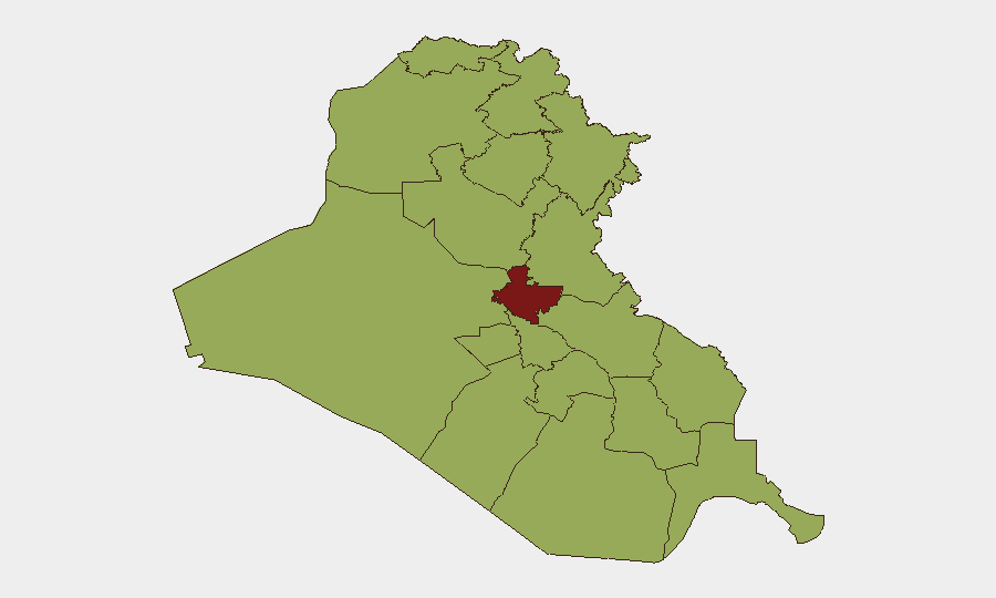
Baghdad Governorate (82.5) remains the dominant driver of national risk due to PMF concentration, government institutions, and proven capacity for organized militant activity; it was directly targeted in the July 28–29 strikes. Diyala (55.1), Kirkuk (52.7), and Wasit (52.5) follow as secondary focal points: these eastern and north-central zones host known PMF supply lines, weapons depots, and cross-border militia infrastructure, making them persistent targets for US action and potential flashpoints for retaliation or internecine sectarian violence. Erbil's elevation (56.4) reflects coalition base presence and concurrent drone activity, establishing it as a node in wider US–Iran proxy contest rather than a primary insurgent stronghold.
How GeoBit Would Assist
Security teams should deploy AOI Monitoring & Early Warning on Baghdad, Diyala, Kirkuk, and Wasit to detect secondary escalation (militia mobilization, weapons movement, retaliatory planning). Network & Actor Analysis and OSINT Fusion (X/Telegram, multi-language feeds, entity extraction) enable real-time tracking of PMF statements, Iranian signaling, and Iraqi government counter-messaging to assess escalation probability. Battle Mapping and GIS & Spatial Analysis support ongoing visualization of strike footprints and conflict geometry across provinces, informing duty-of-care routing and asset protection decisions.
7-Day Outlook
Immediate risk of tit-for-tat drone or missile exchanges between US/Saudi and Iran-aligned forces remains elevated through early August, with secondary risk of Iraqi government internal fracture over sovereignty and PMF control. Expect intensified political messaging, possible additional militia mobilization in eastern provinces, and continued foreign military operations unless diplomatic de-escalation emerges. Civilian and expatriate exposure in Baghdad and eastern governorates should be assessed daily.
Highest-Risk Areas — Ranked
| # | State / Region | Risk |
|---|---|---|
| 1 | Baghdad Governorate | 82.5 |
| 2 | Erbil Governorate | 56.4 |
| 3 | Diyala Governorate | 55.1 |
| 4 | Sulaymaniyah Governorate | 54.9 |
| 5 | Kirkuk Governorate | 52.7 |
| 6 | Karbala | 52.7 |
| 7 | Babil Governorate | 52.5 |
| 8 | Wasit Governorate | 52.5 |
| 9 | Al-Qadisiyah Governorate | 52.5 |
| 10 | Dhi Qar Governorate | 52.5 |
| 11 | Al-Muthanna Governorate | 52.5 |
| 12 | Maysan Governorate | 52.5 |
Sources
Previous Daily Briefs
A new Iraq brief is written every day — each with its own risk map and downloadable CSV. Here's the last week; use the calendar to go further back.
📅 Browse every day by calendar →
Highlighted days have a brief. Tap a day for that day's map & analysis, or “csv” for that day's dataset ($5).
Atlas — our AI intelligence desk — emails them this snapshot personally. Nothing else, no list.