Situation Summary
Mali remains ranked #21 globally for security risk (composite score 71), driven primarily by active insurgency across the north and center. No independently verified incident-level security events were recorded in the last 24–48 hours across any region, including traditionally high-risk areas (Timbuktu, Gao, Ménaka, Mopti, Bamako). Despite this near-term calm, the underlying threat environment—jihadist and separatist armed groups, political tensions, and structural vulnerabilities in transport and governance—remains elevated and volatile.
Key Developments
- No new incident-level events confirmed in Mali during 23–25 July 2026. Open-source monitoring, news wires, and real-time risk platforms report no verified attacks, armed clashes, major arrests, infrastructure damage, or mass civil unrest in the last 24–48 hours.
- Recent baseline incident (Gao region, 18 July): An armed-group ambush was recorded earlier in July but does not represent a new development within the reporting window. This reflects the persistence of threat activity in the north, not a current escalation.
- Political and administrative tension signals: Multiple same-day event signals (25 July) record public statements, prosecutor disapproval, and government detentions in Bamako, indicating ongoing institutional friction but no imminent security event.
- Northern frontier volatility remains structural: Despite no fresh confirmed attacks in the 24–48-hour window, Kidal, Ménaka, and Gao regions continue to host active insurgent and jihadist presence. These areas require continuous monitoring but show no signs of sudden tactical shift.
- Transport and supply-chain risk persists: Road, fuel, and airport vulnerabilities documented in earlier July incidents remain unresolved. No new sabotage or convoy strikes were reported in the last 24–48 hours, but the risk profile has not improved.
Highest-Risk Areas
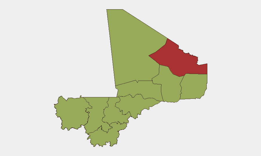
Kidal leads the sub-national risk ranking (79.9), reflecting its proximity to ungoverned territory, active separatist influence, and jihadist presence. Bamako (57.2), despite being the capital, carries significant risk due to political instability, detention patterns, and potential for rapid civil unrest. A second tier of regions—Ménaka, Taoudénit, Gao, Koulikoro, Ségou, Sikasso, Timbuktu, and Mopti—all score 49.9, driven by insurgent activity, limited state presence, and cross-border permeability. The concentration of high risk in the north and northeast reflects the geographic footprint of jihadist and JNIM-affiliated groups; Bamako's elevation reflects political-regime fragility and international scrutiny.
How GeoBit Would Assist
Security teams operating in Mali should deploy AOI (Area-of-Interest) Monitoring & Early Warning on Kidal, Gao, and Ménaka to catch emerging tactical signals before incidents reach public reporting. Conflict & Military mapping (force structure, weapons-capability tracking) combined with Network & Actor Analysis will identify shifts in armed-group posture or command-and-control changes. Real-time OSINT fusion (X/Twitter, Telegram, radio SIGINT) across multiple languages offers early friction signals—political statements, recruitment activity, internal disputes—that often precede major security events. For personnel and asset mobility, Routing & Network Analysis provides alternative journey planning and identifies secondary transit chokepoints.
7-Day Outlook
No imminent major incident is indicated by current signals. However, the structural volatility—ongoing jihadist pressure, political friction in Bamako, and the absence of any security-sector reform momentum—suggests that calm periods may be brief. Organizations should treat the current low-incident window as an opportunity to reinforce contingency plans, pre-position evacuation assets, and strengthen real-time monitoring rather than as a signal of de-escalation.
Highest-Risk Areas — Ranked
| # | State / Region | Risk |
|---|---|---|
| 1 | Kidal | 79.9 |
| 2 | Bamako | 57.2 |
| 3 | Ménaka | 49.9 |
| 4 | Kayes | 49.9 |
| 5 | Taoudénit Region | 49.9 |
| 6 | Gao | 49.9 |
| 7 | Koulikoro | 49.9 |
| 8 | Ségou Region | 49.9 |
| 9 | Sikasso Region | 49.9 |
| 10 | Timbuktu | 49.9 |
| 11 | Mopti | 49.9 |
Sources
Previous Daily Briefs
A new Mali brief is written every day — each with its own risk map and downloadable CSV. Here's the last week; use the calendar to go further back.
📅 Browse every day by calendar →
Highlighted days have a brief. Tap a day for that day's map & analysis, or “csv” for that day's dataset ($5).
Atlas — our AI intelligence desk — emails them this snapshot personally. Nothing else, no list.