Situation Summary
Myanmar remains in active civil war, with the military junta conducting sustained conventional operations against resistance forces across multiple regions. The composite threat score of 97 reflects high-intensity conflict coupled with fragmented governance, organized crime involvement, and humanitarian displacement. Rakhine State is experiencing the most intensive current air campaign, with multiple civilian-impact strikes on 19 July alone. The conflict trajectory shows no near-term de-escalation signals, and infrastructure cutoffs (including potential Starlink restrictions) are beginning to constrain civilian communications and humanitarian coordination.
Key Developments
- Rakhine State airstrikes (19 July): Myanmar military conducted four separate air operations across Rakhine, including strikes on Maei Town (three 300-lb bombs; 5 civilians killed, 22 injured, ~20 homes destroyed), Thandwe Town (five airstrikes with bombs and machine-gun fire; 4 civilians injured), Taungpauk Monastery in Ponnagyun Township (two 300-lb bombs; 3 injured, including 2 monks), and Gwa Township (unspecified casualty count). Civilian infrastructure damage included at least one church and multiple residential areas.
- Resistance counteroffensive in Mandalay Region (19 July): Resistance forces reported coordinated attacks on three junta military positions in Natogyi Township, Mandalay Region, with claims of five soldiers killed. Timing and coordination suggest organized resistance capability in central Myanmar.
- Starlink communications crisis (mid-July, reported 19 July): Over 250 civil society organizations issued urgent public appeal to SpaceX, warning that a blanket Starlink shutdown in Myanmar would sever civilian communications for millions; organizations requested targeted terminal restrictions on scam-operation networks instead. This reflects critical dependency on satellite comms as terrestrial infrastructure degrades.
- Ongoing pattern of civilian harm: All four 19 July airstrikes targeted populated areas, including religious sites and residential wards, with mixed military-civilian proximity; no military-only targets reported in the air operations.
Highest-Risk Areas
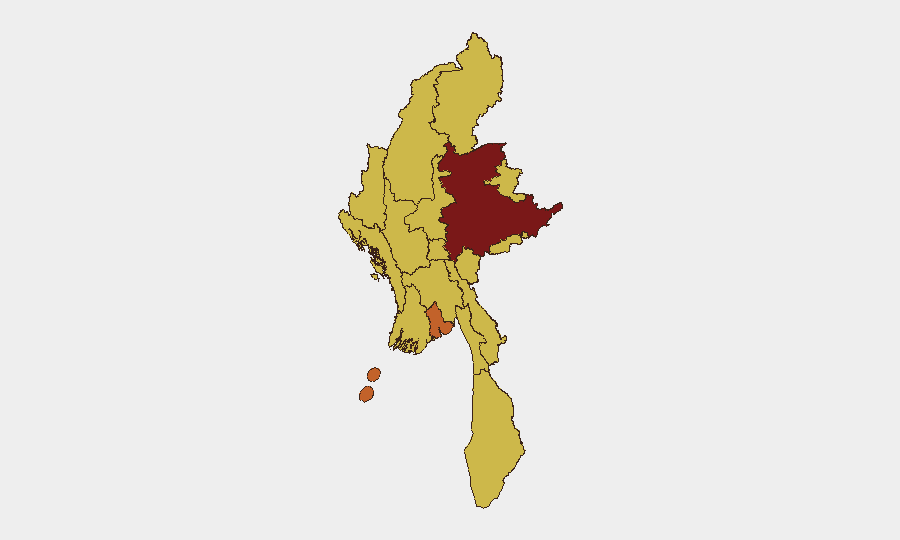
Shan State remains the single highest-risk sub-national area (97.6), likely reflecting persistent armed-group activity, drug-trafficking networks, and border-region instability; however, Rakhine State (ranked 10th at 67.6, but showing acute escalation) is now the immediate operational flashpoint, with four documented air operations in 36 hours and documented civilian casualties. Yangon (74.5) retains elevated risk due to urban protest activity and junta security-force presence. The clustering of 67.6-risk scores across nine other regions—Mandalay, Sagaing, Kachin, Magway, Chin, Tanintharyi, Wa, Ayeyarwady, and Naypyitaw—indicates geographically distributed conflict intensity rather than a single theater.
How GeoBit Would Assist
Security teams should deploy AOI Monitoring & Early Warning on Rakhine's three urban centers (Maei, Thandwe, Gwa) and key resistance strongholds in Shan and Mandalay to track airstrike patterns and military movement. Satellite & Imagery analysis and battle mapping enable real-time damage assessment and force-position updates to inform personnel evacuation and asset protection. OSINT fusion (X/Twitter, Telegram, resistance media) combined with multi-language search and temporal analysis can close the 24–48-hour reporting lag that currently obscures the full scope of incidents.
7-Day Outlook
Rakhine State airstrikes are likely to continue or intensify as junta seeks to suppress resistance activity in the region; civilian exposure remains acute. Resistance forces are demonstrating sustained coordination in central and eastern regions, suggesting the conflict will remain multi-front and unpredictable. Communications infrastructure degradation (via potential Starlink restrictions or junta action) will further complicate real-time situational awareness and duty-of-care coordination for organizations with personnel in-country.
Highest-Risk Areas — Ranked
| # | State / Region | Risk |
|---|---|---|
| 1 | Shan State | 97.6 |
| 2 | Yangon | 74.5 |
| 3 | Tanintharyi Region | 67.6 |
| 4 | Chin | 67.6 |
| 5 | Sagaing Region | 67.6 |
| 6 | Kachin State | 67.6 |
| 7 | Wa State (Northern Region) | 67.6 |
| 8 | Magway | 67.6 |
| 9 | Mandalay | 67.6 |
| 10 | Rakhine | 67.6 |
| 11 | Ayeyarwady | 67.6 |
| 12 | Naypyitaw Union Territory | 67.6 |
Sources
Previous Daily Briefs
A new Myanmar brief is written every day — each with its own risk map and downloadable CSV. Here's the last week; use the calendar to go further back.
📅 Browse every day by calendar →
Highlighted days have a brief. Tap a day for that day's map & analysis, or “csv” for that day's dataset ($5).
Atlas — our AI intelligence desk — emails them this snapshot personally. Nothing else, no list.